Talmage is a census-designated place (CDP) in Mendocino County, California, United States. Talmage is located 2.5 miles (4 km) east-southeast of Ukiah, at an elevation of 627 feet (191 m). The population was 986 at the 2020 census, down from 1,130 in 2010. It lies in the southeastern part of the Ukiah Valley and is home to the City of Ten Thousand Buddhas, one of the largest Chan Buddhist temples in the United States. The town's name honors early settler Junius Talmage.
Elk is an unincorporated community in Mendocino County, California.

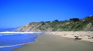
Cape Mendocino, which is located approximately 200 miles (320 km) north of San Francisco, is located on the Lost Coast entirely within Humboldt County, California, United States. At 124° 24' 34" W longitude, it is the westernmost point on the coast of California. The South Cape Mendocino State Marine Reserve and Sugarloaf Island are immediately offshore, although closed to public access due to their protected status. Sugarloaf Island is cited as California's westernmost island.
Hopland is a census-designated place in Mendocino County, California, United States. It is located on the west bank of the Russian River 13 miles (21 km) south-southeast of Ukiah, in the Sanel Valley, at an elevation of 502 feet (153 m). The population was 661 at the 2020 census, down from 756 at the 2010 census.
The Hopland Band of Pomo Indians of the Hopland Rancheria is a federally recognized tribe of Pomo people in Mendocino County, California, south of Ukiah. The Hopland Band Pomos traditionally lived in the Sanel Valley.

Whitethorn is an unincorporated community in Humboldt County, California, United States. It is located 9.5 miles southwest of Garberville, at an elevation of 1,024 feet, with a population of 817. Whitethorn shares a ZIP Code, 95589, with Shelter Cove, California. It is located along California's Lost Coast.

Fruto is an unincorporated community in Glenn County, California. It is located 14 miles (23 km) west-northwest of Willows, at an elevation of 610 feet. It is located along State Route 162. Fruto was established in 1888 as the terminus of the Westside and Mendocino Railroad company and was a shipping point for fruit and wool grown in the area.

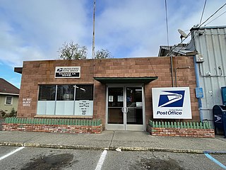
Comptche is an unincorporated community and census-designated place (CDP) in Mendocino County, California, United States. It is located 17 miles (27 km) southeast of Fort Bragg at an elevation of 187 feet (57 m). There is a K–3 primary school serving the town, as well as a small store with gas pump; a post office, and a church. The population was 167 at the 2020 census.
Hearst is an unincorporated community in Mendocino County, California. It is located 13 miles (21 km) north-northwest of Potter Valley, at an elevation of 1,378 feet (420 m).
Englewood is an unincorporated community in Humboldt County, California. It is located 0.5 miles (0.8 km) east-southeast of Redcrest, at an elevation of 364 feet. In 2009, the area was the site of a few homes and a derelict Eel River Sawmills mill.
Fruitland is an unincorporated community in Humboldt County, California. It is located 6 miles east-southeast of Weott, at an elevation of 1,004 feet (306 m).
Yorkville is an unincorporated community in Mendocino County, California. It is located 7.5 miles (12 km) southwest of Hopland, at an elevation of 922 feet.
Rancho Sanel was a 17,754-acre (71.85 km2) Mexican land grant in present-day Mendocino County, California, given in 1844 by Governor Manuel Micheltorena to Fernando Feliz. The grant extended along the Russian River and encompassed present-day Hopland. It is named after a village of the Pomo people near Hopland; the name means sweat-house in the Pomo language. Neither Spanish nor Mexican influence extended into Mendocino County beyond establishing two ranchos in southern Mendocino County: Rancho Sanel in the Sanel Valley in 1844 and Rancho Yokaya in the Ukiah Valley in 1845.
Island Mountain is a resistant formation of volcanic and metavolcanic rock in the Franciscan Assemblage of southwestern Trinity County, California. It was mined for sulfur metal deposits during the first half of the 20th century and was the final obstacle in the construction of a railroad line to Eureka, California in 1914. The name is applied to the range, the peak, a populated place and an abandoned railroad station, tunnel and bridge all but the first located within the S-bend of the Eel River which gave the peak its name.

Mendocino Indian Reservation, a former Indian reservation in Mendocino County, one of the early Indian reservations to be established in California by the federal government for the resettlement of California Indians. It was established in the spring of 1856, in the vicinity of modern Noyo. Its area was 25,000 acres and its boundary extended north from what is now Simpson Lane at 39°24′43″N123°48′30″W to Abalobadiah Creek and east from the Pacific Ocean to a north–south line passing through the summit of Bald Hill.
Black Bear was a gold mining town in Klamath County, now in unincorporated Siskiyou County, California.
Abalobadiah Creek is a stream with its mouth on the coast about a mile above the mouth of Ten Mile River on the Pacific Ocean coast of Mendocino County, California. Its source is at 39°35′21″N123°44′26″W at an elevation of 800 feet (240 m) in the coastal mountains.
Elk is an unincorporated community in Noble County, in the U.S. state of Ohio.
Woodman Peak is a summit in Mendocino County, California. It rises to an elevation of 2,835 feet two miles northeast of Laytonville, California.
Point Cabrillo is a sandstone headland on the Pacific Ocean coast of Mendocino County, California, between the towns of Mendocino, California and Fort Bragg, California. It is the location of the Point Cabrillo Light. Geography-wise, it lies between Point Arena headland/peninsula to the south, and Cape Mendocino, to the north.
