California is a U.S. state on the western coast of North America. Covering an area of 163,696 sq mi (423,970 km2), California is geographically diverse. The Sierra Nevada, the fertile farmlands of the Central Valley, and the arid Mojave Desert of the south are some of the major geographic features of this U.S. state. It is home to some of the world's most exceptional trees: the tallest, most massive, and oldest. It is also home to both the highest and lowest points in the 48 contiguous states. The state is generally divided into Northern and Southern California, although the boundary between the two is not well defined. San Francisco is decidedly a Northern California city and Los Angeles likewise a Southern California one, but areas in between do not often share their confidence in geographic identity. The US Geological Survey defines the geographic center of the state at a point near North Fork, California.

The Intermontane Plateaus of the Western United States is one of eight U.S. Physiographic regions (divisions) of the physical geography of the contiguous United States. The region is composed of intermontane plateaus and mountain ranges. It is subdivided into physiographic provinces, which are each subdivided into physiographic sections.

Owens Valley is the now-arid valley of the Owens River in eastern California in the United States, to the east of the Sierra Nevada and west of the White Mountains and Inyo Mountains on the west edge of the Great Basin. The mountain peaks on either side reach above 14,000 feet (4,300 m) in elevation, while the floor of the Owens Valley is about 4,000 feet (1,200 m), making the valley one of the deepest in the United States. The Sierra Nevada casts the valley in a rain shadow, which makes Owens Valley "the Land of Little Rain." The bed of Owens Lake, now a predominantly dry endorheic alkali flat, sits on the southern end of the valley.

The exposed geology of the Yosemite area includes primarily granitic rocks with some older metamorphic rock. The first rocks were laid down in Precambrian times, when the area around Yosemite National Park was on the edge of a very young North American continent. The sediment that formed the area first settled in the waters of a shallow sea, and compressive forces from a subduction zone in the mid-Paleozoic fused the seabed rocks and sediments, appending them to the continent. Heat generated from the subduction created island arcs of volcanoes that were also thrust into the area of the park. In time, the igneous and sedimentary rocks of the area were later heavily metamorphosed.

The Walker River is a river in west-central Nevada in the United States, approximately 62 miles (100 km) long. Fed principally by snowmelt from the Sierra Nevada mountains of California, it drains an arid portion of the Great Basin southeast of Reno and flows into the endorheic basin of Walker Lake. The river is an important source of water for irrigation in its course through Nevada; water diversions have reduced its flow such that the level of Walker Lake has fallen 160 feet (49 m) between 1882 and 2010. The river was named for explorer Joseph Reddeford Walker.
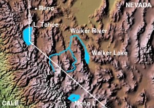
The East Walker River is an approximately 90 miles (140 km) long, tributary of the Walker River, in eastern California and western Nevada in the United States. It drains part of the eastern side of the Sierra Nevada in the watershed of Walker Lake in the Great Basin.

The San Bernardino Mountains are a high and rugged mountain range in Southern California in the United States. Situated north and northeast of San Bernardino and spanning two California counties, the range tops out at 11,489 feet (3,502 m) at San Gorgonio Mountain – the tallest peak in all of Southern California. The San Bernardinos form a significant region of wilderness and are popular for hiking and skiing.

Vasquez Rocks Natural Area Park is a 932-acre (377-hectare) park located in the Sierra Pelona Mountains in northern Los Angeles County, California. It is located in the town of Agua Dulce, between the suburbs of Santa Clarita and Palmdale. The area is also visible from the Antelope Valley Freeway.

The exposed geology of the Death Valley area presents a diverse and complex set of at least 23 formations of sedimentary units, two major gaps in the geologic record called unconformities, and at least one distinct set of related formations geologists call a group. The oldest rocks in the area that now includes Death Valley National Park are extensively metamorphosed by intense heat and pressure and are at least 1700 million years old. These rocks were intruded by a mass of granite 1400 Ma and later uplifted and exposed to nearly 500 million years of erosion.

Ward Creek is a 6.1-mile (9.8 km) eastward-flowing stream in Placer County, California, USA. The creek flows into Lake Tahoe 2.7 miles (4.3 km) south of Tahoe City, California, and has undergone extensive restoration to reduce sediment and surface run-off to maintain the purity of Lake Tahoe.

Sonoma Creek is a 33.4-mile-long (53.8 km) stream in northern California. It is one of two principal drainages of southern Sonoma County, California, with headwaters rising in the rugged hills of Sugarloaf Ridge State Park and discharging to San Pablo Bay, the northern arm of San Francisco Bay. The watershed drained by Sonoma Creek is roughly equivalent to the wine region of Sonoma Valley, an area of about 170 square miles (440 km2). The State of California has designated the Sonoma Creek watershed as a “Critical Coastal Water Resource”. To the east of this generally rectangular watershed is the Napa River watershed, and to the west are the Petaluma River and Tolay Creek watersheds.

The South Warner Wilderness is a federally designated wilderness area 12 miles (19 km) east of Alturas, California, USA. It encompasses more than 70,000 acres (283 km2) of the Warner Mountains. It is within the Modoc National Forest and managed by the US Forest Service. Elevations range from 5,000 feet (1,500 m) to 9,895 feet at Eagle Peak.

The Fish Lake Valley is a 25 miles (40 km) long endorheic valley in southwest Nevada, one of many contiguous inward-draining basins collectively called the Great Basin. The alluvial valley lies just northwest of Death Valley and borders the southeast, and central-northeast flank of the massif of the White Mountains of California. The valley's southern end lies in eastern Inyo County, California. The valley is sparsely populated with ranchers and indigenous Paiute. Business services are located in the valley's only town Dyer.

Simi Valley is a synclinal valley in Southern California in the United States. It is an enclosed or hidden valley surrounded by mountains and hills. It is connected to the San Fernando Valley to the east by the Santa Susana Pass and the 118 freeway, and in the west the narrows of the Arroyo Simi and the Reagan Freeway connect to Moorpark and Ventura, California. The relatively flat bottom of the valley contains soils formed from shales, sandstones, and conglomerates eroded from the surrounding hills of the Santa Susana Mountains to the north, which separate Simi Valley from the Santa Clara River Valley, and the Simi Hills.
Red Clover Creek is a northwestward-flowing stream originating on Horton Ridge east of the Sierra Nevada crest in Plumas County, California, United States. It courses 27 miles (43 km) through Dotta Canyon and the Red Clover Valley, culminating in Last Chance Creek, which flows in turn, into Indian Creek in the Genesee Valley, and from there to the East Branch North Fork Feather River. The Red Clover Valley sits at an elevation of about 5,400 feet (1,600 m) and is located on the east side of the Sierra Nevada crest, approximately 60 miles (97 km) north of Truckee and 30 miles (48 km) southeast of Quincy. This region of the northern Sierra Nevada is known as the Diamond Mountains.
Trout Creek is a northward-flowing stream originating on the west side of Armstrong Pass on the Carson Range in El Dorado County, California, United States.
Chino Creek is a major stream of the Pomona Valley, in the western Inland Empire region of Southern California. It is a tributary of the Santa Ana River.
The Perris Block is the central block of three major fault-bounded blocks of the northern part of the Peninsular Ranges. The Perris Block lies between the Santa Ana Block to the west and the San Jacinto Block to the east. The Perris Block, was named by Walter A. English in 1925 for the city of Perris, located near the center of the block.
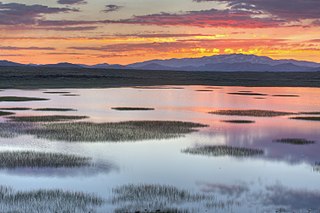
The Alkali Lakes are a series of three large playas located in the Surprise Valley of northeastern California, United States. From north to south they are known as Upper, Middle and Lower Alkali Lake. Upper Alkali Lake is often known simply as Upper Lake, and Lower Alkali Lake as Lower Lake. Although mostly located in Modoc County, California, the eastern edges of Middle and Lower Lakes touch Washoe County, Nevada. The Warner Mountains are located to the west of the three lakes. The lake beds are typically flooded with shallow water in the winter but dry up during most summers.