Camberwell is a district of South London, England, in the London Borough of Southwark, 2+3⁄4 miles southeast of Charing Cross.

The London Borough of Southwark in south London forms part of Inner London and is connected by bridges across the River Thames to the City of London and London Borough of Tower Hamlets. It was created in 1965 when three smaller council areas amalgamated under the London Government Act 1963. All districts of the area are within the London postal district. It is governed by Southwark London Borough Council.

Dulwich is an area in South London, England. The settlement is mostly in the London Borough of Southwark, with parts in the London Borough of Lambeth, and consists of Dulwich Village, East Dulwich, West Dulwich, and the Southwark half of Herne Hill. Dulwich lies in a valley between the neighbouring districts of Camberwell, Crystal Palace, Denmark Hill, Forest Hill, Peckham, Sydenham Hill, and Tulse Hill.

Peckham is a district of South London, England, within the London Borough of Southwark. It is 3.5 miles (5.6 km) south-east of Charing Cross. At the 2001 Census the Peckham ward had a population of 14,720.

New Kent Road is a 1 kilometre (0.6 mi) road in the London Borough of Southwark. The road was created in 1751 when the Turnpike Trust upgraded a local footpath. This was done as part of the general road improvements associated with the creation of Westminster Bridge; in effect it was possible to travel from the West End/ Westminster to the south-east without having to go via the Borough of Southwark but could now cross St George's Fields to the junction of Newington Causeway and Newington Butts which is where New Kent Road starts at Elephant and Castle. The route runs eastward for a few hundred yards to the junction of Great Dover Street and Tower Bridge Road, known as Bricklayers Arms, where it joins the original route to the south-east Old Kent Road.

Camberwell was a civil parish and metropolitan borough in south London, England. Camberwell was an ancient parish in the county of Surrey, governed by an administrative vestry from 1674. The parish was included in the area of responsibility of the Metropolitan Board of Works in 1855 and became part of the County of London in 1889. The parish of Camberwell became a metropolitan borough in 1900, following the London Government Act 1899, with the parish vestry replaced by a borough council. In 1965 the borough was abolished and its former area became part of the London Borough of Southwark in Greater London.

Old Kent Road is a major thoroughfare in South East London, England, passing through the London Borough of Southwark. It was originally part of an ancient trackway that was paved by the Romans and used by the Anglo-Saxons who named it Wæcelinga Stræt. It is now part of the A2, a major road from London to Dover. The road was important in Roman times linking London to the coast at Richborough and Dover via Canterbury. It was a route for pilgrims in the Middle Ages as portrayed in Chaucer's Canterbury Tales, when Old Kent Road was known as Kent Street. The route was used by soldiers returning from the Battle of Agincourt.

Herne Hill is a district in South London, approximately four miles from Charing Cross and bordered by Brixton, Camberwell, Dulwich, and Tulse Hill. It sits to the north and east of Brockwell Park and straddles the boundary between the boroughs of Lambeth and Southwark. There is a road of the same name in the area, as well as a railway station.

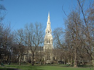
Burgess Park is a public park situated in Camberwell the London Borough of Southwark, and is close to Walworth to the north and Bermondsey to the east. At 56 hectares, it is one of the largest parks in South London.

Fitzroy North is an inner-city suburb of Melbourne, Victoria, Australia, 4 km north-east of Melbourne's Central Business District. Its local government area are the cities of Yarra and Moreland. At the 2011 Census, Fitzroy North had a population of 11,473.

Nunhead is a suburb in the London Borough of Southwark in London, England. It is an inner-city suburb located 4 miles (6.4 km) southeast of Charing Cross. It is the location of the 52-acre (0.21 km2) Nunhead Cemetery. Nunhead has traditionally been a working-class area and, with the adjacent neighbourhoods, is currently going through a lengthy process of gentrification. Nunhead is the location of several underground reservoirs, built by the Southwark and Vauxhall Waterworks Company.

Camberwell and Peckham is a constituency represented in the House of Commons of the UK Parliament since its 1997 creation by Harriet Harman of the Labour Party. Harman had served for the previous constituency of Peckham since 1982. She is a former cabinet minister and the "Mother of the House of Commons", having the longest record of continuous service of any female MP.

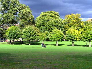
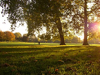
The London Borough of Southwark, occupying a roughly triangular area south of Tower Bridge over the River Thames, considers itself to be one of the greenest boroughs in London, with its 245 hectares of public parkland. There are more than 130 such green areas, ranging from the large areas around Dulwich and Southwark Park in Rotherhithe to the many sports grounds and squares. The main ones are:
Peckham Rye is an open space and road in the London Borough of Southwark in London, England. The roughly triangular open space lies to the south of Peckham town centre. It is managed by Southwark Council and consists of two contiguous areas, with Peckham Rye Common to the north and Peckham Rye Park to the south. The road Peckham Rye forms the western and eastern perimeter of the open space.

Champion Hill is a football stadium in East Dulwich in the London Borough of Southwark. It is the home ground of Dulwich Hamlet.
Southwark Park is located in Rotherhithe, in central South East London, England, and is managed by the London Borough of Southwark. It first opened in 1869 by the Metropolitan Board of Works as one of its first parks. It was designed by Alexander McKenzie and covers 63 acres (250,000 m2). It takes its name from being in what was the old Parliamentary constituency of Southwark at the time of its opening.
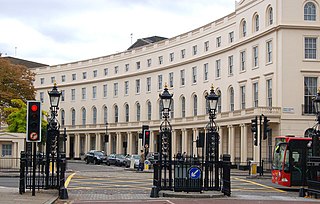
Park Crescent is at the north end of Portland Place and south of Marylebone Road in London. The crescent consists of elegant stuccoed terraced houses by the architect John Nash, which form a semicircle. The crescent is part of Nash's and wider town-planning visions of Roman-inspired imperial West End approaches to Regent's Park. It was originally conceived as a circus (circle) to be named Regent's Circus but instead Park Square was built to the north. The only buildings on the Regent's Park side of the square are small garden buildings, enabling higher floors of the Park Crescent buildings to have a longer, green northern view.

Camberwell Grove is a residential street in Camberwell, London, England, in the Borough of Southwark. It follows the line of a grove of trees, hence the name. The street once led from a Tudor manor house south to the top of a hill, which afforded a view of the City of London, approximately three miles to the north. Today, the grove is part of Camberwell Grove Conservation area.

Tabard Gardens is a small park in Southwark, London. It is located on Tabard Street and gives its name to the surrounding Tabard Gardens Estate. The park was created as part of a slum clearance programme by the London County Council and opened in 1929. It is owned and managed by Southwark Council.

Northbrook Park is a public park located on Baring Road south of Lee Green and north of Grove Park in the London Borough of Lewisham, southeast London, England. It is roughly 9 acres (3.6 ha) in size, and contains a large central field bounded by trees, a children's playground, with a sandpit and splash pool, a multipurpose game court, two football pitches, outdoor gym equipent and a legal graffiti wall. The park was previously a field named Ten-Acre Field, despite actually being 7 acres (2.8 ha), and part of the Baring Estate of Lee. In 1898, Thomas Baring, 1st Earl of Northbrook gifted part of his family's estate to public use in commemoration of the Diamond Jubilee of Queen Victoria. The Park was designed by Lt Col J J Sexby, Chief Officer of the London County Council's Parks Department, then was officially opened on 14 March 1903. In the past the park contained a larger playground, a paddling pool, a pond, a bowling green and a tennis court.
