
The Skagit Valley lies in the northwestern corner of the state of Washington, United States. Its defining feature is the Skagit River, which snakes through local communities which include the seat of Skagit County, Mount Vernon, as well as Sedro-Woolley, Concrete, Lyman-Hamilton, and Burlington.
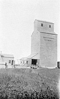
Benito is an unincorporated rural community in the Municipality of Swan Valley West within the Canadian province of Manitoba that held village status prior to January 1, 2015. The community is situated in the Swan River Valley, 37 kilometres southwest of Swan River, 475 kilometres northwest of Winnipeg, and 2 kilometres east of the Saskatchewan border. To the south is Duck Mountain Provincial Park and Forest, to the north is Thunder Hill and further north of Swan River is Porcupine Mountain Provincial Park. Benito is served by PTH 83.

Swedeborg is an unincorporated community in northwestern Pulaski County, Missouri, United States. It is located approximately five miles northeast of Richland on Route 133.
Mound Valley Township is a township in Labette County, Kansas, United States.
Los Trancos Woods is an unincorporated community in San Mateo County, California near the border of Santa Clara County. The US Geological Survey, National Geographic Names Database, show it as a feature type populated place. The area does not have its own unique ZIP code; it is in ZIP code 94028 and area code 650. The community adjoins the City of Palo Alto's Foothills Park. It is on the US Geological Survey's 7.5-minute "Mindego Hill" quadrangle. Coordinates in the National Geographic Names Database are shown as 37°20′58″N122°11′58″W. County documents suggest the community may eventually be annexed by Portola Valley.
There are over 30 lakes named Mud Lake within the U.S. state of Washington.
Copper Mine Gulch is a valley in Marin County, California, United States, which is associated with a small stream.
Ross Valley is a valley in Marin County, California. The city of Ross in addition to all or portions of San Anselmo, Fairfax, Kentfield, and San Rafael are located in the valley. Mount Tamalpais is to the west, the Red Hills to the east and San Rafael Bay to the south.

Tennessee Cove is an embankment off the Pacific Ocean in Marin County, California. It is named after the "S.S. Tennessee", a steamship that ran aground near here on March 6, 1853. All 550 passengers climbed safely onto the beach, and fourteen chests of gold were salvaged before the ship broke up. Remnants of the ship can still be seen during low tide during some winter days on the south end of the beach.
Eastmont is a neighborhood in Oakland, the county seat of Alameda County, California. It lies at an elevation of 95 feet. It was formerly an unincorporated community.

South Camanche Shore is an unincorporated community in Calaveras County, California. It lies at an elevation of 443 feet.

Schilling, formerly Shilling, is an unincorporated community in Fresno County, California. It is located on the Atchison, Topeka and Santa Fe Railroad 2 miles (3.2 km) south-southeast of Lanare at an elevation of 213 feet.
Yorkville is an unincorporated community in Mendocino County, California. It is located 7.5 miles (12 km) southwest of Hopland, at an elevation of 922 feet.
Rancho Boca de la Cañada del Pinole was a 13,316-acre (53.89 km2) Mexican land grant in present-day Contra Costa County, California given in 1842 by Governor Juan Alvarado to María Manuela Valencia. The name means "Mouth of the Pinole Valley" in Spanish. The rancho located between present-day Martinez, Pleasant Hill, Orinda, and Lafayette.

Arlington is a census-designated place (CDP) in southeastern Carbon County, Wyoming, United States. The population was 25 at the 2010 census.
Rancho La Purísima Concepción was a 4,439-acre (17.96 km2) Mexican land grant in present day Santa Clara County, California given in 1840 by Governor Juan Alvarado to José Gorgonio and his son José Ramon, Ohlone Indians. The granted extended from Matadero Creek to Adobe Creek and encompassed present day Los Altos Hills.
Rancho Las Baulines was a 8,911-acre (36.06 km2) Mexican land grant in present-day Marin County, California, given in 1846 by Governor Pío Pico to Gregorio Briones. The grant extended around Bolinas Lagoon and encompassed present-day Stinson Beach and Bolinas.

Sandy Bend is an unincorporated community in Cowlitz County, Washington, south of the city of Castle Rock, west of Washington State Route 411, and to the west of the Cowlitz River. Sandy Bend is located along or near Sandy Bend Road between Castle Rock and West Side Highway. The Sandy Bend community is part of the Castle Rock School District, a K-12 school district of about 1,300 students.
Greenwood is an unincorporated community in Whatcom County, in the U.S. state of Washington.
New Survey is an unincorporated community in Pemiscot County, in the U.S. state of Missouri.


