
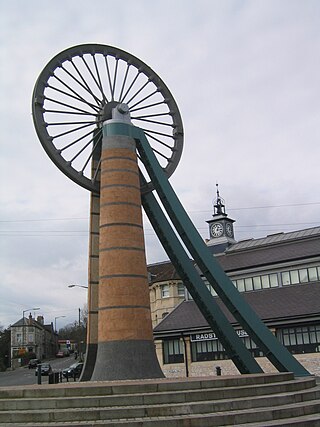
Bedminster is a district of Bristol, England, on the south side of the city. It is also the name of a council ward which includes the central part of the district.
The geology of Shropshire is very diverse with a large number of periods being represented at outcrop. The bedrock consists principally of sedimentary rocks of Palaeozoic and Mesozoic age, surrounding restricted areas of Precambrian metasedimentary and metavolcanic rocks. The county hosts in its Quaternary deposits and landforms, a significant record of recent glaciation. The exploitation of the Coal Measures and other Carboniferous age strata in the Ironbridge area made it one of the birthplaces of the Industrial Revolution. There is also a large amount of mineral wealth in the county, including lead and baryte. Quarrying is still active, with limestone for cement manufacture and concrete aggregate, sandstone, greywacke and dolerite for road aggregate, and sand and gravel for aggregate and drainage filters. Groundwater is an equally important economic resource.
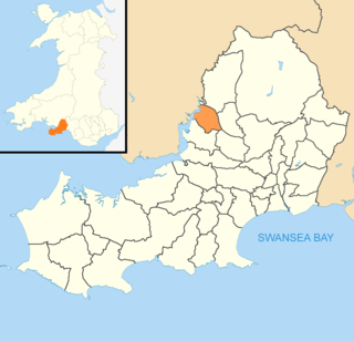
Grovesend is a village in the community of Grovesend and Waungron, City and County of Swansea in Wales. The community has a population of 1,131.
The city of Bristol, England, is divided into many areas, which often overlap or have non-fixed borders. These include Parliamentary constituencies, council wards and unofficial neighbourhoods. There are no civil parishes in Bristol.
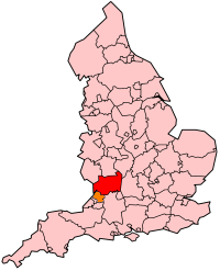
The Somerset Coalfield in northern Somerset, England is an area where coal was mined from the 15th century until 1973. It is part of a larger coalfield which stretched into southern Gloucestershire. The Somerset coalfield stretched from Cromhall in the north to the Mendip Hills in the south, and from Bath in the east to Nailsea in the west, a total area of about 240 square miles (622 km2). Most of the pits on the coalfield were concentrated in the Cam Brook, Wellow Brook and Nettlebridge Valleys and around Radstock and Farrington Gurney. The pits were grouped geographically, with clusters of pits close together working the same coal seams often under the same ownership. Many pits shared the trackways and tramways which connected them to the Somerset Coal Canal or railways for distribution.

The geology of Wales is complex and varied; its study has been of considerable historical significance in the development of geology as a science. All geological periods from the Cryogenian to the Jurassic are represented at outcrop, whilst younger sedimentary rocks occur beneath the seas immediately off the Welsh coast. The effects of two mountain-building episodes have left their mark in the faulting and folding of much of the Palaeozoic rock sequence. Superficial deposits and landforms created during the present Quaternary period by water and ice are also plentiful and contribute to a remarkably diverse landscape of mountains, hills and coastal plains.
The Bristol and North Somerset Railway was a railway line in the West of England that connected Bristol with Radstock, through Pensford and further into northern Somerset, to allow access to the Somerset Coalfield. The line ran almost due south from Bristol and was 16 miles (26 km) long.
Gloucestershire is one of the most geologically and scenically diverse counties in England, with rocks from the Precambrian through to the Jurassic represented. These varying rock-types are responsible for the three major areas of the county, each with its own distinctive scenery and land-use - the Forest of Dean in the west, bordering Wales, the Cotswolds in the east, and in between, the Severn Vale.

The Cumberland Coalfield is a coalfield in Cumbria, north-west England. It extends from Whitehaven in the south to Maryport and Aspatria in the north.
The Leicestershire and South Derbyshire Coalfield in the English Midlands is one of the smaller British coalfields. The two areas are sometimes separately referred to as the South Derbyshire Coalfield and the Leicestershire Coalfield. All of the worked coal seams are contained within the Lower and Middle Coal Measures which are of Upper Carboniferous age.
The Coalbrookdale Coalfield is a coalfield in Shropshire in the English Midlands. It extends from Broseley in the south, northwards to the Boundary Fault which runs northeastwards from the vicinity of The Wrekin past Lilleshall. The former coalfield has been built on by the new town of Telford.

The Canonbie Coalfield is a small and largely concealed coalfield at Canonbie in the south of Scotland. A comprehensive survey by Peach and Horne was published in 1903. Canonbie colliery was worked until 1920, and another mine at Archerbeck continued until 1942.
The Midgeholme Coalfield is a coalfield in Midgeholme, on the border of Cumbria with Northumberland in northern England. It is the largest of a series of small coalfields along the south side of the Tyne Valley and which are intermediate between the Northumberland and Durham Coalfields to the east and the Cumberland Coalfield to the west. Like the other small coalfields to its east, this small outlier of the Coal Measures at Midgeholme occurs on the Stublick-Ninety Fathom Fault System, a zone of faults defining the northern edge of the Alston Block otherwise known as the North Pennines. It is recorded that coal was being mined at Midgeholme in the early seventeenth century. In the 1830s coal trains were being hauled from Midgeholme Colliery along the Brampton Railway by Stephenson's Rocket. The early workings have left a legacy of spoil heaps, bell pits, shafts and adits. There is no current coal production. However in January 2014, Northumberland County Council gave planning permission for the open-cast extraction of 37,000 tonnes of coal at Halton Lea Gate. This may open the way for other applications to mine the coalfield. In 1990 a proposal to mine reserves of 60,000 tonnes of good-quality coal at Lambley, Northumberland was rejected, but the prospect for a successful application has now changed, since the Planning Inspector allowed the development to proceed at Halton Lea Gate on appeal.

The Manchester Coalfield is part of the South Lancashire Coalfield, the coal seams of which were laid down in the Carboniferous Period. Some easily accessible seams were worked on a small scale from the Middle Ages, and extensively from the beginning of the Industrial Revolution in the early 19th century until the last quarter of the 20th century. The Coal Measures lie above a bed of Millstone Grit and are interspersed with sandstones, mudstones, shales, and fireclays. The Lower Coal Measures occupy the high ground of the West Pennine Moors above Bolton and are not worked in the Manchester Coalfield. The most productive of the coal measures are the lower two thirds of the Middle Coal Measures where coal is mined from seams between the Worsley Four Foot and Arley mines. The deepest and most productive collieries were to the south of the coalfield. The coalfield is affected by the northwest to southeast aligned Pendleton Fault along the Irwell Valley and the Rossendale Valley anticline. The Coal Measures generally dip towards the south and west. Numerous other smaller faults affect the coalfield. The Upper Coal Measures are not worked in the Manchester Coalfield.
The Coal Measures Group is a lithostratigraphical term coined to refer to the coal-bearing succession of rock strata which occur in the United Kingdom within the Westphalian Stage of the Carboniferous Period. The succession was previously referred to as the 'Productive Coal Measures'. Other than in Northern Ireland the term is now obsolete in formal use and is replaced by the Pennine Coal Measures Group, Scottish Coal Measures Group and the South Wales Coal Measures Group for the three distinct depositional provinces of the British mainland.
In lithostratigraphy, coal measures are coal-bearing strata, with the term typically applied to European units of the Upper Carboniferous System.
The Pennine Coal Measures Group is a lithostratigraphical term referring to the coal-bearing succession of rock strata which occur in the United Kingdom within the Westphalian Stage of the Carboniferous Period. In formal use, the term replaces the Coal Measures Group as applied to the succession of coal-bearing strata within the Pennine Basin which includes all of the coalfields of northern England and the English Midlands. It includes the largely concealed Canonbie Coalfield of southern Scotland and the coalfields of northeast Wales and the minor Anglesey coalfield.
The geology of the Gower Peninsula in South Wales is central to the area's character and to its appeal to visitors. The peninsula is formed almost entirely from a faulted and folded sequence of Carboniferous rocks though both the earlier Old Red Sandstone and later New Red Sandstone are also present. Gower lay on the southern margin of the last ice sheet and has been a focus of interest for researchers and students in that respect too. Cave development and the use of some for early human occupation is a further significant aspect of the peninsula's scientific and cultural interest.
