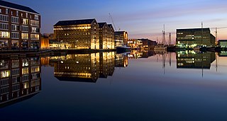
Gloucester is a cathedral city and the county town of Gloucestershire in the South West of England. Gloucester lies on the River Severn, between the Cotswolds to the east and the Forest of Dean to the west; it is sited 19 miles (31 km) east of Monmouth and 17 miles (27 km) east of the border with Wales. Gloucester has a population of around 132,000, including suburban areas. It is a port, linked via the Gloucester and Sharpness Canal to the Severn Estuary.

Bramhope is a village and civil parish in the City of Leeds metropolitan borough, West Yorkshire, England, north of Holt Park and north east of Cookridge.
Rudgeway is a village in South Gloucestershire in south west England, located between Alveston and Almondsbury on the A38 trunk road. It lies west of Earthcott, Latteridge, Iron Acton and Yate on the B4059 road.

Hardwicke is a large village on the A38 road 7 km south of the city of Gloucester, Gloucestershire, England. Despite its proximity to Gloucester, the village comes under Stroud Council. The population of the village taken at the United Kingdom Census 2011 was 3,901.

Quedgeley is a town and civil parish in the city of Gloucester district in Gloucestershire, England. A thin strip of land between the Severn and the Gloucester Ship Canal occupies the west, and the south-eastern part of the town is Kingsway Village, directly to the north of which is Tuffley.

Edwardstone is a village and civil parish in the Babergh district, in the county of Suffolk, England. The parish contains the hamlets of Mill Green, Priory Green, Round Maple and Sherbourne Street, and Edwardstone Woods, a Site of Special Scientific Interest. In 2021 the parish had a population of 375. The parish boarders Boxford, Great Waldingfield, Groton, Little Waldingfield, Milden and Newton.

Forthampton is a village in Gloucestershire, England. The village is located three miles from the market town of Tewkesbury and features "a great number of interesting buildings", fine views, several duck ponds, a church, a collection of thatched cottages and farmsteads, a village hall and a village club. Forthampton was designated a Conservation Area in 2003 due to its special architectural and historic interest, character and appearance which it was desirable to preserve and enhance. Notable features of the village include extensive historic buildings clustered around farm houses situated at the centre of the village, the many roadside ponds and grass verges around and between buildings and significant panoramic views.
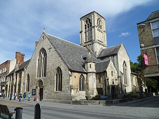
St Mary de Crypt Church, Southgate Street, Gloucester, is an Anglican Church, which was first recorded in 1140 as The Church of the Blessed Mary within Southgate. It is in the Diocese of Gloucester and is located adjacent to the ruins of Greyfriars. It has also been known as Christ Church and St. Mary in the South. St Mary de Crypt is a Grade I listed building.

Longney is a village on the River Severn 5 miles south-west of Gloucester, Gloucestershire, England, within the parish of Longney and Epney. The parish is long and narrow and the main trades are agricultural, with several farms throughout. Longney is the Saxon name meaning a long island. The population of the Longney and Epney parish is 285 (2011).
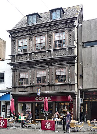
9 and 9A Southgate Street is a 17th-century Jacobean timber-framed merchant's house on Southgate Street, Gloucester. It has been a Grade I listed building since 23 January 1952. 9 Southgate Street is now occupied by Costa Coffee and 9A Southgate Street is occupied by The Tiger's Eye restaurant.

Knowl Green is a hamlet in the civil parish of Belchamp St Paul and the Braintree district of Essex, England.

Colesbourne is a village and civil parish in the Cotswold district of Gloucestershire, England. The village and parish lies within the Cotswolds, a designated Area of Outstanding Natural Beauty.

High Orchard was an industrial area of the city of Gloucester in England that was developed in the 19th century on the former orchard of the Priory of Llanthony Secunda (1136). The area was closely associated with Gloucester Docks immediately to the north, and served by the Gloucester and Sharpness Canal and railway transport. It was the site of Fielding & Platt's Atlas Works and a number of other significant local employers.

Southgate Street is one of the ancient streets in the City of Gloucester, so named because its southern end was originally the location of the south gate in the city's walls. The part beyond the gate as far as Severn Street was sometimes known as Lower Southgate Street. It runs from the crossroads of Northgate, Eastgate, Southgate, and Westgate Streets in the north to Bristol Road in the south.
Hanbury is a civil parish in the district of East Staffordshire, Staffordshire, England. It contains 20 buildings that are recorded in the National Heritage List for England. Of these, one is listed at Grade II*, the middle grade, and the others are at Grade II, the lowest grade. The listed buildings in the parish are houses, including a former manor house and a small country house, cottages, farmhouses and farm buildings, a church and its lych gate, a school, and four mileposts.

The Little Thatch is a 14th-century timber-framed building at 141 Bristol Road, Quedgeley, Gloucester. It is now used as a public house and hotel.
Alrewas is a civil parish in the district of Lichfield, Staffordshire, England. It contains 51 listed buildings that are recorded in the National Heritage List for England. Of these, one is at Grade I, the highest of the three grades, and the others are at Grade II, the lowest grade. The parish contains the village of Alrewas, the smaller settlement of Orgreave, and the surrounding area. Most of the listed buildings are in the village of Alrewas, most of these are houses and cottages, and a high proportion of them are timber framed or have timber-framed cores. The Trent and Mersey Canal and the River Trent pass through the parish, and a bridge crossing the canal is listed. The other listed buildings include a church, memorials in the churchyard, a small country house and its stable block, farmhouses and farm buildings, a public house, two mileposts, and a war memorial.
Kings Bromley is a civil parish in the district of Lichfield, Staffordshire, England. It contains 24 listed buildings that are recorded in the National Heritage List for England. Of these, one is at Grade I, the highest of the three grades, and the others are at Grade II, the lowest grade. The parish contains the village of Kings Bromley and the surrounding countryside. Most of the listed buildings are houses, cottages, farmhouses and farm buildings, many of which are timber framed or have timber framed cores, and some of the houses and cottages have thatched roofs. The Trent and Mersey Canal passes through the parish, and the listed buildings associated with it are two bridges, a lock, a lock keeper's cottage, and a milepost. The other listed buildings are a church, a churchyard cross, structures associated with a former manor house, and a war memorial.
Elland is a town and an unparished area in the metropolitan borough of Calderdale, West Yorkshire, England. Elland ward contains 47 listed buildings that are recorded in the National Heritage List for England. Of these, two are listed at Grade I, the highest of the three grades, two are at Grade II*, the middle grade, and the others are at Grade II, the lowest grade. The ward contains the town of Elland, the hamlet of Blackley, and the surrounding area. The Calder and Hebble Navigation passes through the area, and the listed buildings associated with this are locks, a bridge, a milepost, a lock keeper's house, a warehouse, and an office. The other listed buildings include houses and cottages, churches and associated structures, public houses, a barn, a set of stocks, a mill warehouse, four milestones, a former town hall, a former bank, a war memorial, and two telephone kiosks.


