
Greenland is located between the Arctic Ocean and the North Atlantic Ocean, northeast of Canada and northwest of Iceland. The territory comprises the island of Greenland—the largest island in the world—and more than a hundred other smaller islands. Greenland has a 1.2-kilometer-long (0.75 mi) border with Canada on Hans Island. A sparse population is confined to small settlements along certain sectors of the coast. Greenland possesses the world's second-largest ice sheet.

Eismitte, in English also called Mid-Ice, was a meteorological station established by the 1930-31 German Greenland Expedition in the middle of the Greenland Ice Sheet. The venture took place from July 1930 through August 1931, and established three Arctic stations on the same parallel. A trip back from Eismitte in early November 1930 claimed the life of expedition leader, noted German scientist Alfred Wegener. The station was abandoned on 1 August 1931.
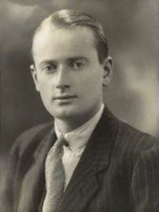
Frederick Spencer Chapman, was a British Army officer and World War II veteran, most famous for his exploits behind enemy lines in Japanese occupied Malaya. His medals include the Distinguished Service Order and Bar, and the Polar Medal. He also received several unofficial awards: the Gill Memorial Medal, Mungo Park Medal, and the Lawrence of Arabia Memorial Medal.

Sir James Mann WordieCBE FRS FRSGS LLD was a Scottish polar explorer and geologist. Friends knew him as Jock Wordie.

John Riddoch Rymill was an Australian polar explorer, who had the rare second clasp added to his Polar Medal.
Henry George "Gino" Watkins FRGS was a British Arctic explorer and nephew of Bolton Eyres-Monsell, 1st Viscount Monsell.

Mont Forel is a mountain in King Christian IX Land, Sermersooq Municipality, Greenland. It is part of the Schweizerland range, also known as 'Schweizerland Alps'.
David Haig-Thomas was a British ornithologist, wildlife photographer, explorer and rower who competed for Great Britain in the 1932 Summer Olympics. He was an army commando during the Second World War, and was killed in action during the Normandy Landings. Haig-Thomas Island in the Canadian Arctic is named after him.
Augustine Courtauld, often called August Courtauld, was a yachtsman and British Arctic explorer, best known for serving as the solo meteorologist of a winter observation post, Icecap Station, located in the interior of Greenland in 1930–1931.
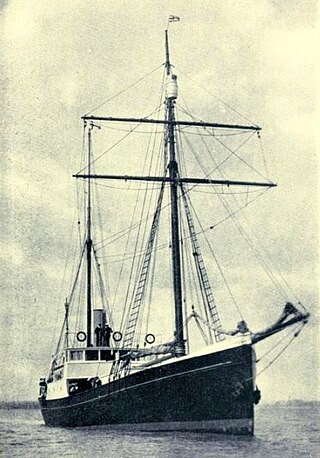
Quest was a low-powered, schooner-rigged steamship that sailed from 1917 until sinking in 1962, best known as the polar exploration vessel of the Shackleton–Rowett Expedition of 1921–1922. It was aboard this vessel that Sir Ernest Shackleton died on 5 January 1922 while in harbour in South Georgia. Prior to and after the Shackleton–Rowett Expedition, Quest operated in commercial service as a seal-hunting vessel or "sealer". Quest was also the primary expedition vessel of the British Arctic Air Route Expedition to the east coast of the island of Greenland in 1930–1931.

The Watkins Range is Greenland's highest mountain range. It is located in King Christian IX Land, Sermersooq municipality.

Kangerlussuaq Fjord is a fjord in eastern Greenland. It is part of the Sermersooq municipality.

King Frederick VI Coast is a major geographic division of Greenland. It comprises the coastal area of Southeastern Greenland in Sermersooq and Kujalleq municipalities fronting the Irminger Sea of the North Atlantic Ocean. It is bordered by King Christian IX Land on the north and the Greenland Ice Sheet to the west.

Schweizerland, also known as Schweizerland Alps, is a mountain range in King Christian IX Land, eastern Greenland. Administratively this range is part of the Sermersooq Municipality. Its highest point is one of the highest peaks in Greenland.

The 1932–33 East Greenland Expedition, sub-titled the Pan Am expedition by some sources, was a small expedition to Greenland led by Henry "Gino" Watkins until his death and then by John Rymill. The expedition was intended to continue the work of the previous British Arctic Air Route Expedition (BAARE) that had mapped unexplored sections of Greenland in 1930–1931.
Quintin Theodore Petroc Molesworth Riley was a British Arctic explorer who was awarded the Polar Medal.

Surgeon Captain Edward W. Bingham, was a British Royal Navy officer and polar explorer who had the rare third clasp added to his Polar Medal.
Captain Percy M. Lemon was a signal officer and British polar explorer who was awarded the Polar Medal.

The Lemon Range or Lemon Mountains is a mountain range in King Christian IX Land, eastern Greenland. Administratively this range is part of the Sermersooq Municipality.
