Norfolk is a county in East Anglia in England. It borders Lincolnshire to the northwest, Cambridgeshire to the west and southwest, and Suffolk to the south. Its northern and eastern boundaries are the North Sea and to the northwest, The Wash. The county town is the city of Norwich. With an area of 2,074 square miles (5,370 km2) and a population of 859,400, Norfolk is a largely rural county with a population density of 401 per square mile. Of the county's population, 40% live in four major built up areas: Norwich (213,000), Great Yarmouth (63,000), King's Lynn (46,000), and Thetford (25,000).

East Anglia is a geographical area in the East of England. The area included has varied but the legally defined NUTS 2 statistical unit comprises the counties of Norfolk, Suffolk and Cambridgeshire, including the City of Peterborough unitary authority area. The name derives from the Anglo-Saxon kingdom of the East Angles, a tribe whose name originated in Anglia, in what is now northern Germany.

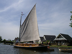
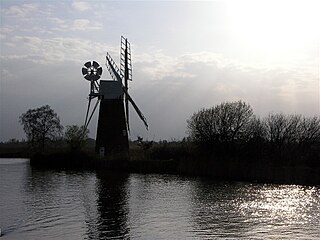
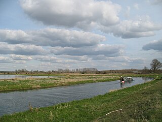
The Broads is a network of mostly navigable rivers and lakes in the English counties of Norfolk and Suffolk. The lakes, known as broads, were formed by the flooding of peat workings. The Broads, and some surrounding land, were constituted as a special area with a level of protection similar to a national park by the Norfolk and Suffolk Broads Act 1988. The Broads Authority, a special statutory authority responsible for managing the area, became operational in 1989.

The River Waveney is a river which forms the boundary between Suffolk and Norfolk, England, for much of its length within The Broads. The "ey" part of the name means "river" thus the name is tautological.

Trinity Broads is a 316.8-hectare (783-acre) biological Site of Special Scientific Interest north of Great Yarmouth in Norfolk. They are in The Broads Special Area of Conservation. They are also part of the Broads National Park in Norfolk, England, comprising 5 broads in total. The three largest are Rollesby Broad, Ormesby Broad and Filby Broad, and there are two much smaller broads named Lily Broad and Ormesby Little Broad. They are managed by the Broads Authority.
The Broads Authority is the agency which has statutory responsibility for the Broads in England. Originally, the Nature Conservancy Council, pressed for a special authority to manage the Broads which had been neglected for a long time. In 1978, the forerunner to the present-day Broads Authority was established by the Countryside Commission. Ten years later, it had become clear that a statutory body was needed, and a special Act of Parliament, the Norfolk and Suffolk Broads Act 1988 made the Broads Authority into a special statutory authority which gave it parity yet establishing key differences with national park authorities.
This page gives an overview of the complex structure of environmental and cultural conservation in the United Kingdom.
The River Ant is a tributary river of the River Bure in the county of Norfolk, England. It is 27 kilometres (17 mi) long, and has an overall drop of 27 metres from source to mouth. It is said that the Ant was formerly known as the River Smale and that this is the origin of the name of the village of Smallburgh.
The River Little Ouse is a river in the east of England, a tributary of the River Great Ouse. For much of its length it defines the boundary between Norfolk and Suffolk.

The River Gipping is the source river for the River Orwell in the county of Suffolk in East Anglia, England, which is named from the village of Gipping, and which gave its name to the former Gipping Rural District. The name is unrelated to the name of Ipswich. although the County Town takes its name from Gippeswic. It rises near Mendlesham Green and flows in a south-westerly direction to reach Stowmarket. From there it flows towards the south or south east, passing through Needham Market and a number of villages to reach Ipswich, where it becomes the Orwell. The river has supplied power to a number of watermills, several of which are still standing. None is operational, although the mill at Baylham retains most of its machinery, and is the only complete mill on the river.

The national parks of the United Kingdom,, are areas of relatively undeveloped and scenic landscape. Despite their similar name, they are quite different from national parks in many other countries, which are usually owned and managed by the government as a protected community resource, and which do not usually include permanent human communities. In the UK, designation as a national park may include substantial settlements and human land uses which are often integral parts of the landscape, and land within a national park remains largely in private ownership. These parks are not truly national parks according to the internationally accepted standard of the IUCN but they are areas of outstanding landscape where habitation and commercial activities are restricted.

The National Parks and Access to the Countryside Act 1949 is an Act of the Parliament of the United Kingdom which created the National Parks Commission which later became the Countryside Commission and then the Countryside Agency, which became Natural England when it merged with English Nature in 2006. The Act provided the framework for the creation of National Parks and Areas of Outstanding Natural Beauty in England and Wales, and also addressed public rights of way and access to open land. The Act was passed in 1949 with all-party support, as part of the reconstruction of the UK by the Labour government after World War II.

Filby Broad is one of five broads (lakes) in the Trinity Broads in Norfolk, England. It lies within the Broads National Park, adjacent to the village of Filby. The broad has an abundant selection of birds and wildlife.

Breckland in Norfolk and Suffolk is a 39,433 hectare Special Protection Area (SPA) under the European Union Directive on the Conservation of Wild Birds. The SPA partly overlaps the 7,544 hectare Breckland Special Area of Conservation. As a landscape region it is an unusual natural habitat of England. It comprises the gorse-covered sandy heath that lies mostly in the south of the county of Norfolk but also in the north of Suffolk. An area of considerable interest for its unusual flora and fauna, it lies to the east of another unusual habitat, the Fens, and to the south west of the Broads. The typical tree of this area is the Scots pine. Breckland is one of the driest areas in England.

The Norfolk Wherry Trust is a waterway society and UK registered charity number 1084156, based at Womack Water near Ludham in the Norfolk Broads, Norfolk, England.

The East Anglian Waterways Association is a waterway society and an umbrella organisation in East Anglia, England, UK.
Andrew John Lees was a scientist, and environmentalist. He was born at Sandown Nursing Home, Great Yarmouth, the eldest of the four sons of Edward Andrew Lees, who was a Great Yarmouth Borough Councillor and Hotelier and his wife Beryl Lees . He studied zoology, botany and philosophy at the University of Wales in Cardiff receiving an honours degree in 1971. He then spent a period working for the Nature Conservancy Council (NCC).

Barnby Broad and Marshes is a Site of Special Scientific Interest (SSSI) in the Waveney district of the English county of Suffolk. The site is 189.6 hectares in size. It is in the parishes of North Cove and Barnby, located between Beccles and Lowestoft in the north of the county. The site is bordered on its southern edge by the East Suffolk railway line and to the north by the River Waveney. It is a Special Area of Conservation, a Special Protection Area under the EC Birds Directive, and a Ramsar internationally important wetland site. There are two Suffolk Wildlife Trust nature reserves in the site, Castle Marshes and North Cove.

The Norfolk and Suffolk Broads Act 1988 is an Act of the Parliament of the United Kingdom which created the Broads Authority. It is the framework for the creation of Broads, an area qualifying for special conservation on account of its ecological value and giving the Broads equivalent status and funding to the national parks of England and Wales.