
Hoover Dam is a concrete arch-gravity dam in the Black Canyon of the Colorado River, on the border between the U.S. states of Nevada and Arizona. Constructed between 1931 and 1936, during the Great Depression, it was dedicated on September 30, 1935, by President Franklin D. Roosevelt. Its construction was the result of a massive effort involving thousands of workers, and cost over 100 lives. In bills passed by Congress during its construction, it was referred to as the Hoover Dam, after President Herbert Hoover, but was named the Boulder Dam by the Roosevelt administration. In 1947, the name Hoover Dam was restored by Congress.

The Colorado River is one of the principal rivers in the Southwestern United States and in northern Mexico. The 1,450-mile-long (2,330 km) river, the 5th longest in the United States, drains an expansive, arid watershed that encompasses parts of seven U.S. states and two Mexican states. The name Colorado derives from the Spanish language for "colored reddish" due to its heavy silt load. Starting in the central Rocky Mountains of Colorado, it flows generally southwest across the Colorado Plateau and through the Grand Canyon before reaching Lake Mead on the Arizona–Nevada border, where it turns south toward the international border. After entering Mexico, the Colorado approaches the mostly dry Colorado River Delta at the tip of the Gulf of California between Baja California and Sonora.

Glen Canyon Dam is a concrete arch-gravity dam in the southwestern United States, located on the Colorado River in northern Arizona, near the city of Page. The 710-foot-high (220 m) dam was built by the Bureau of Reclamation (USBR) from 1956 to 1966 and forms Lake Powell, one of the largest man-made reservoirs in the U.S. with a capacity of more than 25 million acre-feet (31 km3). The dam is named for Glen Canyon, a series of deep sandstone gorges now flooded by the reservoir; Lake Powell is named for John Wesley Powell, who in 1869 led the first expedition to traverse the Colorado River's Grand Canyon by boat.

Lake Mead is a reservoir formed by the Hoover Dam on the Colorado River in the Southwestern United States. It is located in the states of Nevada and Arizona, 24 mi (39 km) east of Las Vegas. It is the largest reservoir in the US in terms of water capacity. Lake Mead provides water to the states of Arizona, California, and Nevada as well as some of Mexico, providing sustenance to nearly 20 million people and large areas of farmland.
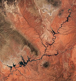
Lake Powell is a reservoir on the Colorado River in Utah and Arizona, United States. It is a major vacation destination visited by approximately two million people every year. It holds 24,322,000 acre-feet (3.0001×10¹⁰ m3) of water when full, second in the United States to only Lake Mead - though Lake Mead has fallen below Lake Powell in size several times during the 21st century in terms of volume of water, depth and surface area.

The Imperial Diversion Dam is a concrete slab and buttress, ogee weir structure across the California/Arizona border, 18 miles (29 km) northeast of Yuma. Completed in 1938, the dam retains the waters of the Colorado River into the Imperial Reservoir before desilting and diversion into the All-American Canal and the Gila Project aqueduct. Between 1932 and 1940, the Imperial Irrigation District (IID) relied on the Inter-California Canal and the Imperial Canal and Alamo River.

The All-American Canal is an 82-mile-long (132 km) aqueduct, located in southeastern California. It conveys water from the Colorado River into the Yuma Project, the Imperial Valley, and to nine cities. It is the Imperial Valley's only water source, and replaced the Alamo Canal, which was located mostly in Mexico. The Imperial Dam, about 30 miles (48 km) northeast of Yuma, Arizona on the Colorado River, diverts water into the All-American Canal, which runs to just west of Calexico, California before its last branch heads mostly north into the Imperial Valley. Smaller canals branching off the All-American Canal move water into the Yuma Valley and the Imperial Valley. These canal systems irrigate up to 630,000 acres (250,000 ha) of crop land and have made possible a greatly increased crop yield in this area, originally one of the driest on earth. It is the largest irrigation canal in the world, carrying a maximum of 26,155 cubic feet per second (740.6 m3/s). Agricultural runoff from the All-American Canal drains into the Salton Sea.

Diamond Valley Lake is a man-made off-stream reservoir located near Hemet, California, United States. It is one of the largest reservoirs in Southern California and one of the newest. It has a capacity of 800,000 acre-feet (990,000,000 m3). The lake nearly doubled the area's surface water storage capacity and provides additional water supplies for drought, peak summer, and emergency needs.

The Colorado River Compact is a 1922 agreement that regulates water distribution among seven states in the southwestern United States. The contract is about the area within the drainage basin of the Colorado River.

The Metropolitan Water District of Southern California is a regional wholesaler and the largest supplier of treated water in the United States. The name is usually shortened to "Met," "Metropolitan," or "MWD." It is a cooperative of fourteen cities, eleven municipal water districts, and one county water authority, that provides water to 19 million people in a 5,200-square-mile (13,000 km2) service area. It was created by an act of the California State Legislature in 1928, primarily to build and operate the Colorado River Aqueduct. Metropolitan became the first contractor to the State Water Project in 1960.

Friant Dam is a concrete gravity dam on the San Joaquin River in central California in the United States, on the boundary of Fresno and Madera Counties. It was built between 1937 and 1942 as part of a U.S. Bureau of Reclamation (USBR) water project to provide irrigation water to the southern San Joaquin Valley. The dam impounds Millerton Lake, a 4,900-acre (2,000 ha) reservoir about 15 miles (24 km) north of Fresno.

San Luis Dam, also known as B.F. Sisk Dam, is a major earth-filled dam in Merced County, California, which forms San Luis Reservoir, the largest off-stream reservoir in the United States. The dam and reservoir are located in the Diablo Range to the east of Pacheco Pass and about 10 miles (16 km) west of Los Banos. San Luis Dam, a jointly-owned state and federal facility, stores more than 2 million acre feet (2.5 km3) of water for the California State Water Project and the federal Central Valley Project. Although the dam is located in the valley of San Luis Creek, the majority of its water comes from man-made aqueducts which are supplied from other rivers in Northern California.

The Colorado–Big Thompson Project is a federal water diversion project in Colorado designed to collect West Slope mountain water from the headwaters of the Colorado River and divert it to Colorado's Front Range and plains. In Colorado, approximately 80% of the state's precipitation falls on the West Slope, in the Rocky Mountains, while around 80% of the state's growing population lives along the eastern slope, between the cities of Fort Collins and Pueblo.

The California State Water Project, commonly known as the SWP, is a state water management project in the U.S. state of California under the supervision of the California Department of Water Resources. The SWP is one of the largest public water and power utilities in the world, providing drinking water for more than 27 million people and generating an average of 6,500 GWh of hydroelectricity annually. However, as it is the largest single consumer of power in the state itself, it has a net usage of 5,100 GWh.

The New Waddell Dam is an embankment dam on the Agua Fria River in Maricopa County, Arizona, 35 miles (56 km) northwest of Phoenix. It serves as part of the Central Arizona Project (CAP) while also providing water for the Maricopa Water District. The dam creates Lake Pleasant with water from the Agua Fria and also the CAP aqueduct. In addition, it affords flood protection, hydroelectric power production and recreational opportunities. Construction on the dam began in 1985 and ended in 1994. Its reservoir submerged the Old Waddell Dam which was completed in 1927 after decades of planning.
The Imperial Irrigation District (IID) is an irrigation district that serves the Imperial Valley and a large portion of the Coachella Valley in the Colorado Desert region of Southern California. Established under the State Water Code, the IID supplies roughly 500,000 acres (200,000 ha) of Imperial Valley farmland with raw Colorado River water to support irrigation. IID also supplies electrical energy to the Imperial and Coachella valleys.

The Bear River is a tributary of the Feather River in the Sierra Nevada, winding through four California counties: Yuba, Sutter, Placer, and Nevada. About 73 miles (117 km) long, the river flows generally southwest through the Sierra then west through the Central Valley, draining a narrow, rugged watershed of 295 square miles (760 km2).
The Central Utah Project is a United States federal water project that was authorized for construction under the Colorado River Storage Project Act of April 11, 1956, as a participating project. In general, the Central Utah Project develops a portion of Utah's share of the yield of the Colorado River, as set out in the Colorado River Compact of 1922.
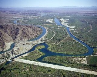
The Yuma Project is a U.S. Bureau of Reclamation project built to irrigate over 68,000 acres (280 km2) of land in Yuma County, Arizona and parts of Imperial County, California. The project is designed to exploit year-round farming conditions and water from the Colorado River. It consists of the Laguna Diversion Dam, pumping plants, a power plant, a 53-mile (85 km) system of canals, 218 miles (351 km) of lateral canals, levees and drains. The project began in 1903 and the majority of the work was completed by 1915. It was the first dam and reclamation project on the Colorado River and workers had to overcome many natural and logistical obstacles to build and maintain it. The Laguna Diversion Dam was replaced by the Imperial Dam as the Project's water source between 1941 and 1948. Today, it serves 275 farms and over 94,000 people.

The Colorado River is a major river of the western United States and northwest Mexico in North America. Its headwaters are in the Rocky Mountains where La Poudre Pass Lake is its source. Located in north central Colorado it flows southwest through the Colorado Plateau country of western Colorado, southeastern Utah and northwestern Arizona where it flows through the Grand Canyon. It turns south near Las Vegas, Nevada, forming the Arizona–Nevada border in Lake Mead and the Arizona–California border a few miles below Davis Dam between Laughlin, Nevada and Needles, California before entering Mexico in the Colorado Desert. Most of its waters are diverted into the Imperial Valley of Southern California. In Mexico its course forms the boundary between Sonora and Baja California before entering the Gulf of California. This article describes most of the major features along the river.

