Related Research Articles
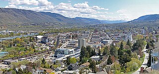
Kamloops is a city in south-central British Columbia, Canada, at the confluence of the North and South Thompson Rivers, which join to become the Thompson River in Kamloops, and east of Kamloops Lake. It is located in the Thompson-Nicola Regional District, whose district offices are based here. The surrounding region is sometimes referred to as the Thompson Country.

The Village of Pouce Coupe is a small town in northeastern British Columbia, Canada, and a member municipality of the Peace River Regional District. It was originally named 'Pouskapie's Prairie', after the name of the local native band chief. The 2.06-square-kilometre (0.80 sq mi) municipality is home to 792 residents.
Tkʼemlúps te Secwépemc, abbreviated TteS and previously known as the Kamloops Indian Band, is a First Nations government within the Shuswap Nation Tribal Council, which represents ten of the seventeen Secwepemc band governments, all in the southern Central Interior region, spanning the Thompson and Shuswap districts. It is one of the largest of the 17 groups into which the Secwepemc (Shuswap) nation was divided when the Colony of British Columbia established an Indian reserve system in the 1860s.
Juniper Ridge is a community located in the city of Kamloops, British Columbia. It is situated at the south-east end of the city on a hillside south of the South Thompson River. There is a convenience store at the entrance to the community, and the area is serviced by an elementary school. It is accessible only by one road, Highland Rd.: however, a formerly washed out dirt road has been refilled allowing emergency access to the Rose Hill area. Most of the streets in this neighbourhood are named after rivers in the province, such as: Skeena, Nechako, Omineca, Babine, Coldwater, etc. Tennis courts, an ice rink with bright lighting, and a dog park are located at the local community centre, Juniper Park.

Barnhartvale, originally Barnhart Vale, is located at the southeast end of Kamloops, south of Dallas in British Columbia, Canada. The area includes riding stables, farms, and ranches. There is a local Esso gas station, and a local elementary school, Robert L. Clemitson. The main road which runs through Barnhartvale is Barnhartvale Road. Todd Road and Pratt Road are the main accesses through the subdivided western portion of Barnhartvale.
Aberdeen is a neighbourhood in the southern area of Kamloops, British Columbia. It is bordered by Highway 5A to the east and the Trans Canada Highway to the north. Located on the slope of the southern hills overlooking Kamloops, Aberdeen overlooks the city and surrounding Thompson River valley from the south. The neighbourhood gets its name John Hamilton-Gordon, seventh Earl of Aberdeen, Governor General of Canada from 1893 to 1898. He visited Kamloops in November 1894.

Chase is a village located in the Interior of British Columbia, Canada. It has a population of 2,399, and its main industries are forestry and tourism. It is located at the outlet of Little Shuswap Lake, which is the source of the South Thompson River. Chase Creek, which drops over three small waterfalls before flowing through the town, enters the South Thompson just below the lake's outlet.

Barriere is a district municipality in central British Columbia, Canada, located 66 km (41 mi) north of the larger city of Kamloops on Highway 5. It is situated at the confluence of the Barrière River and North Thompson Rivers in the Central North Thompson Valley.

Heffley Creek is a neighbourhood of Kamloops, British Columbia, Canada along Highway 5. The city's northernmost community, it is bordered by the North Thompson River to the west, Sun Peaks to the east, Rayleigh to the south, and Vinsulla to the north. It contains a general store, community hall and elementary school. Along with the Rayleigh neighborhood, it is physically separated from the rest of Kamloops by the Thompson River and by the Kamloops Indian Reserve; Heffley Creek is located within the limits of the City of Kamloops.
Sahali is a neighbourhood in South Kamloops, British Columbia, Canada, bordered by the Aberdeen and Downtown districts. It is home to most of Kamloops' major grocery and big box stores. It is also site of one of British Columbia's newest universities: Thompson Rivers University. The neighbourhood is the largest in Kamloops and consists of an Upper and Lower Sahali, with an estimated total population of about 12,000 in 2003.

Sea Island is an island in the Fraser River estuary in the city of Richmond, British Columbia, Canada. It is located south of the city of Vancouver and northwest of Lulu Island.

Newton is a town centre of the city in Surrey, British Columbia. It is the location for the previous Surrey City Hall and Courthouse, a local Surrey Public Library branch, and a Kwantlen Polytechnic University campus. The studios of radio station Red FM are also located here.
The West End is a South Shore neighbourhood of Kamloops, British Columbia in Canada. It is the city's oldest residential neighbourhood and has the largest proportion of heritage-designated homes.
Bradner is a community within the City of Abbotsford, British Columbia, Canada, located in a rural northwest region of that city which also includes Mount Lehman. Bradner occupies a height of land above the Fraser River, immediately across which is the community of Silverdale, a part of the District of Mission, and Ruskin, on the border between Mission and Maple Ridge. On the floodplain below to the west is the Langley rural neighbourhood of Glen Valley, while on the floodplain to the east, which is called Matsqui Prairie, the nearest Abbotsford neighbourhood is Matsqui Village. Bradner was formerly part of the District of Matsqui, which in 1995 was amalgamated into the City of Abbotsford.
Batchelor Heights is a neighbourhood of the city of Kamloops, British Columbia, Canada. Its name derives from that of Batchelor Hill, a local landmark named for Owen Salisbury Batchelor, an early settler, prospector and rancher who lived in the area.
Batchelor Hill 733 m (2405 ft) prominence: 128 m, is a hill overlooking the city of Kamloops, British Columbia, Canada, immediately northwest of the city and north of the neighbourhood of Brocklehurst. It is the namesake of the Batchelor Hills aka Batchelor Heights neighbourhood and also of the small Batchelor Range, which runs north from it on the side of the Kamloops Plateau but does not include it.
Dallas is a neighbourhood of the City of Kamloops, British Columbia, Canada. It has an urban area separated from the Kamloops population centre, with a population of 4,445 as of the Canada 2011 Census.

North Kamloops is a neighbourhood and former town located in the City of Kamloops, British Columbia, Canada. It is located immediately to the northwest of Downtown Kamloops across the confluence of the North and South Thompson Rivers. In 2016, North Kamloops had a population of 10,995, or 12.2% of Kamloops' total population of 90,280, and had the highest population density of any neighbourhood in the city at 2,750 people per km2. North Kamloops is one of four neighbourhoods the City of Kamloops considers part of its Core, the others being Downtown, Sagebrush, and the West End - all on the south shore of the city.
Tranquille is a neighbourhood of the City of Kamloops, British Columbia, Canada, located on the northeast side of Kamloops Lake. It is the site of the Tranquille Sanatorium, a home for the mentally disabled, a tuberculosis sanatorium, and originally the Kamloops Home for Men. It gets its name from that of the Tranquille River, which enters Kamloops Lake in this area, and so indirectly is named for Chief Tranquille, or Pacamoose, who was the leader of the Secwepemc people in this region in the early 19th Century.
Tranquille Sanatorium was built in 1907 to treat tuberculosis, which was known as the "white plague" back then. It was a ranch beforehand. The BC government bought the land for the sanatorium. As the tuberculosis epidemic was spreading in the 1900s, a small community known as Tranquille was built around it. Originally, the facility was called the King Edward VII Sanatorium and served only to treat tuberculosis. The community built around the facility had gardens, houses, a gymnasium, a farm, a fire department, a auditorium, a cafeteria, a laundry mat, tennis courts, a steam plant, a school for handicapped children named “Stsmemelt Village”, and many more facilities, In 1958, the hospital closed and was reopened in 1959 to treat the mentally ill. It closed permanently in 1983 but briefly functioned as a detention center for young offenders until the 1990s. In September 1991, an Italian developer, Giovanni Camporese, the president of A&A Foods, bought the land for turning it into a resort and renamed it "Padova City" as a reminder of the place he was born. There were plans for the demolition of the site but governmental interference's and Camporese's unrelated 1997 case prevented it. The Tranquille Sanatorium has a medical lab in the middle of it.
References
- ↑ Akrigg, G. P. V., Akrigg, H. B. (1970). 1001 British Columbia Place Names. Canada: Discovery Press.
50°42′00″N120°25′00″W / 50.70000°N 120.41667°W
| | This article about a location in the Thompson-Nicola Regional District, Canada is a stub. You can help Wikipedia by expanding it. |