
Olive is a town in Ulster County, New York, United States. The town is west of Kingston, New York, and is inside the Catskill Park. The population was 4,226 at the 2020 census.

The Catskill Mountains, also known as the Catskills, are a physiographic province and subrange of the larger Appalachian Mountains, located in southeastern New York. As a cultural and geographic region, the Catskills are generally defined as those areas close to or within the borders of the Catskill Park, a 700,000-acre (2,800 km2) forest preserve protected from many forms of development under New York state law.

The Morristown Line is an NJ Transit commuter rail line connecting Morris and Essex counties to New York City, via either New York Penn Station or Hoboken Terminal. Out of 60 inbound and 58 outbound daily weekday trains, 28 inbound and 26 outbound Midtown Direct trains use the Kearny Connection to Penn Station; the rest go to Hoboken. Passengers can transfer at Newark Broad Street or Summit to reach the other destination. On rail system maps the line is colored dark green, and its symbol is a drum, a reference to Morristown's history during the American Revolution.
The Ulster and Delaware Railroad (U&D) was a railroad located in the state of New York. It was often advertised as "The Only All-Rail Route to the Catskill Mountains." At its greatest extent, the U&D extended 107 miles (172 km) from Kingston Point on the Hudson River through the Catskill Mountains to its western terminus at Oneonta, passing through the counties of Ulster, Delaware, Schoharie and Otsego.

West Hurley, MP 9.8, later MP 10.2, was a railroad station on the Ulster and Delaware Railroad in West Hurley, New York that was constructed in the late nineteenth century and rebuilt during the construction of the Ashokan Reservoir. The original station was made of wood. It was later torn down and temporarily replaced with a board-and-batten shed close to Woodstock, which created much local indignation. A new brick station to replace it was constructed at the West Hurley Dike of the Ashokan Reservoir. The depot was torn down in 1967.

Boiceville Railroad Station was built by the Ulster and Delaware Railroad to serve the community of Boiceville, New York. Located at MP 21.3, Boiceville was the westernmost depot to be removed as a result of the construction of the Ashokan Reservoir. Although the community of Boiceville was submerged, the station site remains above the reservoir level, at a point just west of where the old railroad right of way slips under the waters of the reservoir, and just east of where it diverges from the new line.

The Ashokan Reservoir is a reservoir in Ulster County, New York. It is at the eastern end of the Catskill Park, and is one of several in the region created to provide the City of New York with water. It is the city's deepest reservoir at 190 feet (58 m) near the dam at the former site of Bishop Falls.

Ashokan was a former railroad station located in the Shokan section of the town of Olive, Ulster County, New York, United States. Located 16.2 miles (26.1 km) from the terminus at Kingston Point in Kingston, it was located along the Ulster and Delaware Railroad, later the Catskill Mountain Branch of the New York Central Railroad. The station opened on June 8, 1913, when the railroad abandoned their former alignment due to the construction of the Ashokan Reservoir. The railroad moved the station depot at Brown's Station to Ashokan for service.

Esopus Creek is a 65.4-mile-long (105.3 km) tributary of the Hudson River that drains the east-central Catskill Mountains in the U.S. state of New York. From its source at Winnisook Lake on the slopes of Slide Mountain, the Catskills' highest peak, it flows across Ulster County to the Hudson at Saugerties. Many tributaries extend its watershed into neighboring Greene County and a small portion of Delaware County. Midway along its length, it is impounded at Olive Bridge to create Ashokan Reservoir, the first of several built in the Catskills as part of New York City's water supply system. Its own flow is supplemented 13 miles (21 km) above the reservoir by the Shandaken Tunnel, which carries water from the city's Schoharie Reservoir into the creek.
The Catskill Mountain Railroad is a heritage tourist railroad based in Kingston, New York, that began operations in 1982. The railroad leases a 4.7-mile portion of the former New York Central Railroad Catskill Mountain branch from Kingston to Stony Hollow, New York. The tracks are owned by Ulster County, New York, which bought them in 1979 from the bankruptcy estate of the Penn Central Railroad. The railroad's current permit with Ulster County expires on December 31, 2028.

New York State Route 28A (NY 28A) is an east–west state highway in Ulster County, New York, in the United States. It extends for nearly 20 miles (32 km) along the south side of Ashokan Reservoir in Catskill Park, serving as a southerly alternate route of NY 28 through the area. Many of the communities along its length, such as West Shokan and Olivebridge, are relocated versions of those condemned for the reservoir's construction. Near Olivebridge, NY 28A intersects NY 213, the only other state route that NY 28A intersects aside from its parent, NY 28.

Cold Brook is a former railroad station in the Boiceville section of the town of Olive, Ulster County, New York, United States. Located on Cold Brook Road, just north of New York State Route 28A next to Esopus Creek, Cold Brook station served the New York Central Railroad's Catskill Mountain Branch, formerly the Ulster and Delaware Railroad. The station was located 22.1 miles (35.6 km) northwest of Kingston Point station in the city of Kingston.
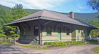
Phoenicia station is a repurposed train station located on High Street just south of Phoenicia, New York, United States. It is a frame building that opened in 1899.

Brown's Station, MP 15.8, was one of the pre-fabricated stations that was built for the Ulster and Delaware Railroad in the early 1900s, this one being constructed in 1900: the same year the railroad reached Oneonta. This was one of the stations that was located in the Ashokan Valley, and served the small town of Brown's Station, New York, which is now underwater.
The Delaware and Northern Railroad was a small railroad in Delaware County, New York, that was founded in 1905, and was planned to go from East Branch, where it would make a connection with the New York, Ontario and Western Railway, to Arkville, where it would connect with the Ulster and Delaware. This line ran close to the banks of the East Branch of the Delaware River, and had plans of expansion, but never made it far, only getting to Arkville. The line was scrapped in 1942, when the Pepacton Reservoir took over its right-of-way and forced the D&N to go out of business.
This Ulster and Delaware train station, MP 19.2, was a busy station, serving an even busier town. This station was actually located in the village of West Shokan, with the actual town of Shokan being a mile east of the station itself. This station was the stop for summer residents staying at boarding houses, and a stop for local people going to church or school. The station was abandoned on June 8, 1913, and the site is now underwater, as the Ashokan Reservoir was built where 12.45 miles (20.04 km) of U&D trackage used to be.

The Wallkill Valley Railroad is a defunct railroad which once operated in Ulster and Orange counties in upstate New York. Its corridor was from Kingston in the north to Montgomery in the south, with a leased extension to Campbell Hall. It crossed both the Wallkill River and Rondout Creek.
Brown's Station was a hamlet in the Esopus Valley of southeastern Ulster County, New York, United States. It was submerged by the waters of the Ashokan Reservoir, an artificial lake built between 1906 and 1915 to supply fresh water to New York City.

Haines Falls is an abandoned train station in Haines Falls, New York. It was owned by the Ulster and Delaware Railroad. The abandoned station was restored in 1999 and is one of two surviving U&D branch stations. It is now the headquarters of the Mountain Top Historical Society. It is also the start of the Kaaterskill Rail Trail, a scenic hiking trail along the former railway.
Michael P. Hein is an American politician who served as the 1st County Executive of Ulster County, serving until February 10, 2019 after having first been elected on November 4, 2008. Prior to the creation of this position, the 2008 ratification by referendum of the Ulster County Charter, he was the Ulster County Administrator.
