Dybła is a village in the administrative district of Gmina Grajewo, within Grajewo County, Podlaskie Voivodeship, in north-eastern Poland. It lies approximately 8 kilometres (5 mi) south of Grajewo and 72 km (45 mi) north-west of the regional capital Białystok.
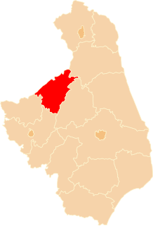
Barwiki is a village in the administrative district of Gmina Radziłów, within Grajewo County, Podlaskie Voivodeship, in north-eastern Poland. It lies approximately 4 kilometres (2 mi) south-east of Radziłów, 30 km (19 mi) south of Grajewo, and 58 km (36 mi) north-west of the regional capital Białystok.
Borawskie-Awissa is a village in the administrative district of Gmina Radziłów, within Grajewo County, Podlaskie Voivodeship, in north-eastern Poland. It lies approximately 5 kilometres (3 mi) north of Radziłów, 23 km (14 mi) south of Grajewo, and 62 km (39 mi) north-west of the regional capital Białystok.
Brychy is a village in the administrative district of Gmina Radziłów, within Grajewo County, Podlaskie Voivodeship, in north-eastern Poland. It lies approximately 7 kilometres (4 mi) south-east of Radziłów, 32 km (20 mi) south of Grajewo, and 55 km (34 mi) north-west of the regional capital Białystok.
Czachy is a village in the administrative district of Gmina Radziłów, within Grajewo County, Podlaskie Voivodeship, in north-eastern Poland. It lies approximately 5 kilometres (3 mi) south-east of Radziłów, 30 km (19 mi) south of Grajewo, and 57 km (35 mi) north-west of the regional capital Białystok.
Czerwonki is a village in the administrative district of Gmina Radziłów, within Grajewo County, Podlaskie Voivodeship, in north-eastern Poland. It lies approximately 7 kilometres (4 mi) north of Radziłów, 21 km (13 mi) south of Grajewo, and 65 km (40 mi) north-west of the regional capital Białystok.
Kieljany is a village in the administrative district of Gmina Radziłów, within Grajewo County, Podlaskie Voivodeship, in north-eastern Poland. It lies approximately 7 kilometres (4 mi) north-east of Radziłów, 21 km (13 mi) south of Grajewo, and 62 km (39 mi) north-west of the regional capital Białystok.
Klimaszewnica is a village in the administrative district of Gmina Radziłów, within Grajewo County, Podlaskie Voivodeship, in north-eastern Poland. It lies approximately 10 kilometres (6 mi) north-east of Radziłów, 21 km (13 mi) south of Grajewo, and 60 km (37 mi) north-west of the regional capital Białystok.
Kownatki is a village in the administrative district of Gmina Radziłów, within Grajewo County, Podlaskie Voivodeship, in north-eastern Poland. It lies approximately 7 kilometres (4 mi) north-east of Radziłów, 21 km (13 mi) south of Grajewo, and 62 km (39 mi) north-west of the regional capital Białystok.
Kramarzewo is a village in the administrative district of Gmina Radziłów, within Grajewo County, Podlaskie Voivodeship, in north-eastern Poland. It lies approximately 7 kilometres (4 mi) north of Radziłów, 21 km (13 mi) south of Grajewo, and 63 km (39 mi) north-west of the regional capital Białystok.
Mikuty is a village in the administrative district of Gmina Radziłów, within Grajewo County, Podlaskie Voivodeship, in north-eastern Poland. It lies approximately 6 kilometres (4 mi) west of Radziłów, 29 km (18 mi) south of Grajewo, and 64 km (40 mi) north-west of the regional capital Białystok.
Mścichy is a village in the administrative district of Gmina Radziłów, within Grajewo County, Podlaskie Voivodeship, in north-eastern Poland. It lies approximately 6 kilometres (4 mi) north-east of Radziłów, 25 km (16 mi) south of Grajewo, and 58 km (36 mi) north-west of the regional capital Białystok.
Okrasin is a village in the administrative district of Gmina Radziłów, within Grajewo County, Podlaskie Voivodeship, in north-eastern Poland. It lies approximately 5 kilometres (3 mi) east of Radziłów, 26 km (16 mi) south of Grajewo, and 57 km (35 mi) north-west of the regional capital Białystok.
Ostrowik is a village in the administrative district of Gmina Radziłów, within Grajewo County, Podlaskie Voivodeship, in north-eastern Poland. It lies approximately 5 kilometres (3 mi) east of Radziłów, 26 km (16 mi) south of Grajewo, and 57 km (35 mi) north-west of the regional capital Białystok.
Racibory is a village in the administrative district of Gmina Radziłów, within Grajewo County, Podlaskie Voivodeship, in north-eastern Poland. It lies approximately 2 kilometres (1 mi) south-east of Radziłów, 28 km (17 mi) south of Grajewo, and 59 km (37 mi) north-west of the regional capital Białystok.
Rydzewo Szlacheckie is a village in the administrative district of Gmina Radziłów, within Grajewo County, Podlaskie Voivodeship, in north-eastern Poland. It lies approximately 9 kilometres (6 mi) north of Radziłów, 20 km (12 mi) south of Grajewo, and 67 km (42 mi) north-west of the regional capital Białystok.
Wypychy is a village in the administrative district of Gmina Radziłów, within Grajewo County, Podlaskie Voivodeship, in north-eastern Poland. It lies approximately 5 kilometres (3 mi) south-west of Radziłów, 31 km (19 mi) south of Grajewo, and 61 km (38 mi) north-west of the regional capital Białystok.
Zakrzewo is a village in the administrative district of Gmina Radziłów, within Grajewo County, Podlaskie Voivodeship, in north-eastern Poland. It lies approximately 6 kilometres (4 mi) north-west of Radziłów, 24 km (15 mi) south of Grajewo, and 66 km (41 mi) north-west of the regional capital Białystok.
Kudłaczewo is a village in the administrative district of Gmina Wąsosz, within Grajewo County, Podlaskie Voivodeship, in north-eastern Poland. It lies approximately 8 kilometres (5 mi) north-east of Wąsosz, 12 km (7 mi) south of Grajewo, and 70 km (43 mi) north-west of the regional capital Białystok.
Zalesie is a village in the administrative district of Gmina Wąsosz, within Grajewo County, Podlaskie Voivodeship, in north-eastern Poland. It lies approximately 7 kilometres (4 mi) east of Wąsosz, 14 km (9 mi) south of Grajewo, and 68 km (42 mi) north-west of the regional capital Białystok.