Gmina Radziłów

Last updated
Gmina Radziłów
Radziłów Commune
Gmina
POL gmina Radzilow COA.svg
Coat of arms
POL powiat grajewski gmina Radzilow.svg
Gmina Radziłów within the Grajewo County
Coordinates(Radziłów): 53°24′39″N22°24′36″E / 53.41083°N 22.41000°E / 53.41083; 22.41000 Coordinates: 53°24′39″N22°24′36″E / 53.41083°N 22.41000°E / 53.41083; 22.41000
CountryFlag of Poland.svg  Poland
Voivodeship Podlaskie
County Grajewo
Seat Radziłów
Area
  Total 199.38 km2 (76.98 sq mi)
Population (2011 [1] )
  Total 5,024
  Density 25/km2 (65/sq mi)

Gmina Radziłów is a rural gmina (administrative district) in Grajewo County, Podlaskie Voivodeship, in north-eastern Poland. Its seat is the village of Radziłów, which lies approximately 27 kilometres (17 mi) south of Grajewo and 61 km (38 mi) north-west of the regional capital Białystok.

Gmina administrative division of Poland

The gmina is the principal unit of the administrative division of Poland, similar to a municipality. As of 2010 there were 2,478 gminy throughout the country. The word gmina derives from the German word Gemeinde, meaning "community".

Grajewo County County in Podlaskie, Poland

Grajewo County is a unit of territorial administration and local government (powiat) in Podlaskie Voivodeship, north-eastern Poland. It came into being on January 1, 1999, as a result of the Polish local government reforms passed in 1998. Its administrative seat and largest town is Grajewo, which lies 76 kilometres (47 mi) north-west of the regional capital Białystok. The county also contains the towns of Szczuczyn, lying 15 km (9 mi) south-west of Grajewo, and Rajgród, 19 km (12 mi) north-east of Grajewo.

Podlaskie Voivodeship Voivodeship in Poland

Podlaskie Voivodeship or Podlasie Province is a voivodeship (province) in northeastern Poland. It borders on Masovian Voivodeship to the west, Warmian-Masurian Voivodeship to the northwest, Lublin Voivodeship to the south, the Belarusian Voblasts of Grodno and Brest to the east, the Lithuanian Counties of Alytus and Marijampolė to the northeast, and the Kaliningrad Oblast of Russia to the north.

Contents

The administrative district (Polish: gmina) covers an area of 199.38 square kilometres (77.0 sq mi), and as of 2006 its total population is 5,114 (5,024 in 2011).

Villages

Gmina Radziłów contains the villages and settlements of Barwiki, Borawskie-Awissa, Borawskie-Awissa-Kolonia, Brodowo, Brychy, Czachy, Czaple, Czerwonki, Dębówka, Dusze, Glinki, Grąd, Janowo, Karwowo, Kieljany, Klimaszewnica, Konopki, Konopki-Awissa, Kownatki, Kramarzewo, Łoje-Awissa, Łoje-Gręzko, Mikuty, Mścichy, Okrasin, Ostrowik, Racibory, Radziłów, Radziłów-Kolonia, Rydzewo Szlacheckie, Rydzewo-Pieniążek, Słucz, Słucz-Kolonie, Sośnia, Święcienin, Święcienin-Kolonia, Szlasy, Szyjki, Wiązownica, Wypychy, Zakrzewo and Zawisie.

Barwiki Village in Podlaskie, Poland

Barwiki is a village in the administrative district of Gmina Radziłów, within Grajewo County, Podlaskie Voivodeship, in north-eastern Poland. It lies approximately 4 kilometres (2 mi) south-east of Radziłów, 30 km (19 mi) south of Grajewo, and 58 km (36 mi) north-west of the regional capital Białystok.

Borawskie-Awissa Village in Podlaskie, Poland

Borawskie-Awissa is a village in the administrative district of Gmina Radziłów, within Grajewo County, Podlaskie Voivodeship, in north-eastern Poland. It lies approximately 5 kilometres (3 mi) north of Radziłów, 23 km (14 mi) south of Grajewo, and 62 km (39 mi) north-west of the regional capital Białystok.

Borawskie-Awissa-Kolonia Village in Podlaskie, Poland

Borawskie-Awissa-Kolonia is a village in the administrative district of Gmina Radziłów, within Grajewo County, Podlaskie Voivodeship, in north-eastern Poland.

Neighbouring gminas

Gmina Radziłów is bordered by the districts of Goniądz, Grajewo, Jedwabne, Przytuły, Trzcianne and Wąsosz.

Gmina Goniądz Gmina in Podlaskie, Poland

Gmina Goniądz is an urban-rural gmina in Mońki County, Podlaskie Voivodeship, in north-eastern Poland. Its seat is the town of Goniądz, which lies approximately 11 kilometres (7 mi) north-west of Mońki and 51 km (32 mi) north-west of the regional capital Białystok.

Gmina Grajewo Gmina in Podlaskie, Poland

Gmina Grajewo is a rural gmina in Grajewo County, Podlaskie Voivodeship, in north-eastern Poland. Its seat is the town of Grajewo, although the town is not part of the territory of the gmina.

Gmina Jedwabne Gmina in Podlaskie, Poland

Gmina Jedwabne is an urban-rural gmina in Łomża County, Podlaskie Voivodeship, in north-eastern Poland. Its seat is the town of Jedwabne, which lies approximately 20 kilometres (12 mi) north-east of Łomża and 61 km (38 mi) west of the regional capital Białystok.

Related Research Articles

Gmina Zawady Gmina in Podlaskie, Poland

Gmina Zawady is a rural gmina in Białystok County, Podlaskie Voivodeship, in north-eastern Poland. Its seat is the village of Zawady, which lies approximately 34 kilometres (21 mi) west of the regional capital Białystok.

Gmina Stupsk is a rural gmina in Mława County, Masovian Voivodeship, in east-central Poland. Its seat is the village of Stupsk, which lies approximately 11 kilometres (7 mi) south-east of Mława and 98 km (61 mi) north of Warsaw.

Gmina Rajgród Gmina in Podlaskie, Poland

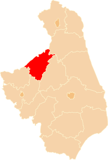
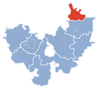
Gmina Rajgród is an urban-rural gmina in Grajewo County, Podlaskie Voivodeship, in north-eastern Poland. Its seat is the town of Rajgród, which lies approximately 19 kilometres (12 mi) north-east of Grajewo and 75 km (47 mi) north-west of the regional capital Białystok.

Gmina Wąsosz, Podlaskie Voivodeship Gmina in Podlaskie, Poland

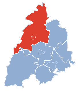
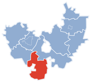
Gmina Wąsosz is a rural gmina in Grajewo County, Podlaskie Voivodeship, in north-eastern Poland. Its seat is the village of Wąsosz, which lies approximately 17 kilometres (11 mi) south-west of Grajewo and 73 km (45 mi) north-west of the regional capital Białystok.

Gmina Miastkowo Gmina in Podlaskie, Poland

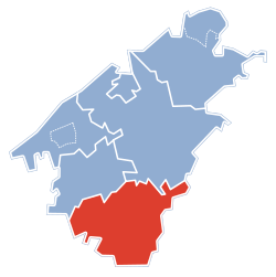
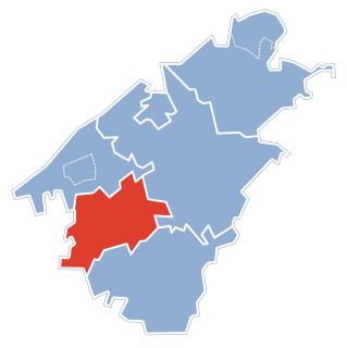
Gmina Miastkowo is a rural gmina in Łomża County, Podlaskie Voivodeship, in north-eastern Poland. Its seat is the village of Miastkowo, which lies approximately 18 kilometres (11 mi) west of Łomża and 91 km (57 mi) west of the regional capital Białystok.

Gmina Przytuły Gmina in Podlaskie, Poland

Gmina Przytuły is a rural gmina in Łomża County, Podlaskie Voivodeship, in north-eastern Poland. Its seat is the village of Przytuły, which lies approximately 27 kilometres (17 mi) north-east of Łomża and 64 km (40 mi) north-west of the regional capital Białystok.

Gmina Śniadowo Gmina in Podlaskie, Poland

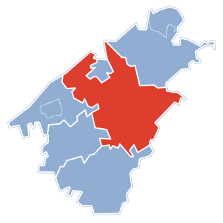
Gmina Śniadowo is a rural gmina in Łomża County, Podlaskie Voivodeship, in north-eastern Poland. Its seat is the village of Śniadowo, which lies approximately 17 kilometres (11 mi) south-west of Łomża and 80 km (50 mi) west of the regional capital Białystok.

Gmina Miłki is a rural gmina in Giżycko County, Warmian-Masurian Voivodeship, in northern Poland. Its seat is the village of Miłki, which lies approximately 14 kilometres (9 mi) south-east of Giżycko and 92 km (57 mi) east of the regional capital Olsztyn.

Konopki is a village in the administrative district of Gmina Radziłów, within Grajewo County, Podlaskie Voivodeship, in north-eastern Poland.

Konopki-Awissa Village in Podlaskie, Poland

Konopki-Awissa is a village in the administrative district of Gmina Radziłów, within Grajewo County, Podlaskie Voivodeship, in north-eastern Poland.

Łoje-Awissa Village in Podlaskie, Poland

Łoje-Awissa is a village in the administrative district of Gmina Radziłów, within Grajewo County, Podlaskie Voivodeship, in north-eastern Poland. It lies approximately 5 kilometres (3 mi) south-east of Radziłów, 31 kilometres (19 mi) south of Grajewo, and 56 kilometres (35 mi) north-west of the regional capital Białystok.

Rydzewo Szlacheckie Village in Podlaskie, Poland

Rydzewo Szlacheckie is a village in the administrative district of Gmina Radziłów, within Grajewo County, Podlaskie Voivodeship, in north-eastern Poland. It lies approximately 9 kilometres (6 mi) north of Radziłów, 20 km (12 mi) south of Grajewo, and 67 km (42 mi) north-west of the regional capital Białystok.

Rydzewo-Pieniążek Village in Podlaskie, Poland

Rydzewo-Pieniążek is a village in the administrative district of Gmina Radziłów, within Grajewo County, Podlaskie Voivodeship, in north-eastern Poland. It lies approximately 6 kilometres (4 mi) north-west of Radziłów, 23 km (14 mi) south of Grajewo, and 65 km (40 mi) north-west of the regional capital Białystok.

Słucz, Podlaskie Voivodeship Village in Podlaskie, Poland

Słucz is a village in the administrative district of Gmina Radziłów, within Grajewo County, Podlaskie Voivodeship, in north-eastern Poland. It lies approximately 6 kilometres (4 mi) north-west of Radziłów, 26 km (16 mi) south of Grajewo, and 66 km (41 mi) north-west of the regional capital Białystok.

Słucz-Kolonie Village in Podlaskie, Poland

Słucz-Kolonie is a village in the administrative district of Gmina Radziłów, within Grajewo County, Podlaskie Voivodeship, in north-eastern Poland. It lies approximately 4 kilometres (2 mi) west of Radziłów, 27 km (17 mi) south of Grajewo, and 64 km (40 mi) north-west of the regional capital Białystok.

Wypychy, Grajewo County Village in Podlaskie, Poland

Wypychy is a village in the administrative district of Gmina Radziłów, within Grajewo County, Podlaskie Voivodeship, in north-eastern Poland. It lies approximately 5 kilometres (3 mi) south-west of Radziłów, 31 km (19 mi) south of Grajewo, and 61 km (38 mi) north-west of the regional capital Białystok.

References

  1. Demographic Yearbook of Poland 2012