Świętoszów is a village in the administrative district of Gmina Osiecznica, within Bolesławiec County, Lower Silesian Voivodeship, in south-western Poland in the Lower Silesian Wilderness, on the river Kwisa. Prior to 1945 it was in Germany.

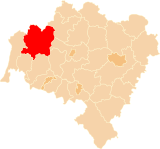
Osiecznica is a village in Bolesławiec County, Lower Silesian Voivodeship, in south-western Poland. It is the seat of the administrative district (gmina) called Gmina Osiecznica. It lies approximately 13 km (8 mi) north-west of Bolesławiec, and 116 km (72 mi) west of the regional capital Wrocław.
Nowa Wieś is a village in the administrative district of Gmina Bolesławiec, within Bolesławiec County, Lower Silesian Voivodeship, in south-western Poland. Prior to 1945 it was in Germany. It lies approximately 8 kilometres (5 mi) north-east of Bolesławiec and 103 km (64 mi) west of the regional capital Wrocław.
Trzebień Mały is a village in the administrative district of Gmina Bolesławiec, within Bolesławiec County, Lower Silesian Voivodeship, in south-western Poland. Prior to 1945 it was in Germany. It lies approximately 15 kilometres (9 mi) north of Bolesławiec and 107 km (66 mi) west of the regional capital Wrocław.
Nowa Kuźnia is a village in the administrative district of Gmina Gromadka, within Bolesławiec County, Lower Silesian Voivodeship, in south-western Poland.
Czerna is a village in the administrative district of Gmina Nowogrodziec, within Bolesławiec County, Lower Silesian Voivodeship, in south-western Poland. It lies approximately 4 km (2 mi) north-west of Nowogrodziec, 16 km (10 mi) west of Bolesławiec, and 119 km (74 mi) west of the regional capital Wrocław.
Nowa Wieś is a village in the administrative district of Gmina Nowogrodziec, within Bolesławiec County, Lower Silesian Voivodeship, in south-western Poland.
Zagajnik is a village in the administrative district of Gmina Nowogrodziec, within Bolesławiec County, Lower Silesian Voivodeship, in south-western Poland.
Ławszowa is a village in the administrative district of Gmina Osiecznica, within Bolesławiec County, Lower Silesian Voivodeship, in south-western Poland.
Ołobok is a village in the administrative district of Gmina Osiecznica, within Bolesławiec County, Lower Silesian Voivodeship, in south-western Poland. It lies approximately 16 kilometres (10 mi) north-west of Osiecznica, 28 km (17 mi) north-west of Bolesławiec, and 127 km (79 mi) west of the regional capital Wrocław.
Osieczów is a village in the administrative district of Gmina Osiecznica, within Bolesławiec County, Lower Silesian Voivodeship, in south-western Poland. It lies approximately 5 km (3 mi) south of Osiecznica, 10 km (6 mi) west of Bolesławiec, and 114 km (71 mi) west of the regional capital Wrocław.
Kliczków is a village in the administrative district of Gmina Osiecznica, within Bolesławiec County, Lower Silesian Voivodeship, in south-western Poland. Kliczków is the location of a notable castle dating from 1297.
Przejęsław is a village in the administrative district of Gmina Osiecznica, within Bolesławiec County, Lower Silesian Voivodeship, in south-western Poland. It lies approximately 5 km (3 mi) north of Osiecznica, 16 km (10 mi) north-west of Bolesławiec, and 117 km (73 mi) west of the regional capital Wrocław.
Tomisław is a village in the administrative district of Gmina Osiecznica, within Bolesławiec County, Lower Silesian Voivodeship, in south-western Poland. It lies approximately 13 km (8 mi) north-west of Bolesławiec and 115 km (71 mi) west of the regional capital Wrocław.
Długokąty is a village in the administrative district of Gmina Osiecznica, within Bolesławiec County, Lower Silesian Voivodeship, in south-western Poland. Prior to 1945 it was in Germany.
Jelenie Rogi is a village in the administrative district of Gmina Osiecznica, within Bolesławiec County, Lower Silesian Voivodeship, in south-western Poland. Prior to 1945 it was in Germany.
Jeziory is a village in the administrative district of Gmina Osiecznica, within Bolesławiec County, Lower Silesian Voivodeship, in south-western Poland. Prior to 1945 it was in Germany.
Luboszów is an unincorporated village in the administrative district of Gmina Osiecznica, within Bolesławiec County, Lower Silesian Voivodeship, in south-western Poland.
Poświętne is a village in the administrative district of Gmina Osiecznica, within Bolesławiec County, Lower Silesian Voivodeship, in south-western Poland. It lies approximately 12 kilometres (7 mi) north-west of Osiecznica, 24 km (15 mi) north-west of Bolesławiec, and 125 km (78 mi) west of the regional capital Wrocław.