
The Stone Arch Bridge is a former railroad bridge crossing the Mississippi River at Saint Anthony Falls in downtown Minneapolis, Minnesota. It is the only arched bridge made of stone on the entire Mississippi River. It is the second oldest bridge on the river next to Eads Bridge. The bridge was built to connect the railway system to the new Union Depot, which at that time was planned to be built between Hennepin Avenue and Nicollet Avenue. The bridge was completed in 1883, costing $650,000 at the time. 117 Portland Avenue is the general address of the historic complex.

Path is a network of underground pedestrian tunnels, elevated walkways, and at-grade walkways connecting the office towers of Downtown Toronto, Ontario, Canada. It connects more than 70 buildings via 30 kilometres (19 mi) of tunnels, walkways, and shopping areas. According to Guinness World Records, Path is the largest underground shopping complex in the world, with 371,600 square metres (4,000,000 sq ft) of retail space which includes over 1,200 retail fronts (2016). As of 2016, over 200,000 residents and workers use the Path system daily with the number of private dwellings within walking distance at 30,115.
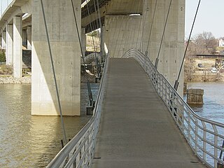
The Robert E. Lee Memorial Bridge in Richmond, Virginia carries U.S. Route 1 and U.S. Route 301 across the James River at the Fall Line.

The James River and Kanawha Canal was a partially built canal in Virginia intended to facilitate shipments of passengers and freight by water between the western counties of Virginia and the coast. Ultimately its towpath became the roadbed for a rail line following the same course.

The San Antonio River Walk is a city park and special-case pedestrian street in San Antonio, Texas, one level down from the automobile street. The River Walk winds and loops under bridges as two parallel sidewalks lined with restaurants and shops, connecting the major tourist draws such as the Shops at Rivercenter, the Arneson River Theatre, Marriage Island, La Villita, HemisFair Park, the Tower Life Building, the San Antonio Museum of Art, the Pearl, and the city's five Spanish colonial missions, which have been named a World Heritage Site, which includes the Alamo. During the annual springtime Fiesta San Antonio, the River Parade features flowery floats that float down the river.

Louisville Waterfront Park is both a non-profit organization and an 85-acre (340,000 m2) public park adjacent to the downtown area of Louisville, Kentucky and the Ohio River. Specifically, it is adjacent to Louisville's wharf and Riverfront Plaza/Belvedere, which are situated to the west of the park. Once a wasteland of scrap yards and abandoned industrial buildings, Waterfront Park is now a vibrant green space that welcomes over 2.2 million visitors each year. Located in the park is the Big Four Bridge which connects the city of Louisville with the City of Jeffersonville, Indiana. Waterfront Park is home to some of Louisville's most exciting celebrations, such as the Fourth of July at Waterfront Park, Forecastle Festival, WFPK Waterfront Wednesdays and Thunder Over Louisville. In 2013 the park won the Rudy Bruner Award for Urban Excellence a national design award that seeks to identify and honor places that address economic and social concerns in urban design.

City of Parks is a municipal project to create a continuous paved pedestrian and biking trail around the city of Louisville, Kentucky while also adding a large amount of park land. The project was announced on February 22, 2005. Current plans call for making approximately 4,000 acres (1,600 ha) of the Floyds Fork floodplain in eastern Jefferson County into park space, expanding area in the Jefferson Memorial Forest, and adding riverfront land and wharfs along the Riverwalk Trail and Levee Trail. There are also plans to connect the 100-mile (160 km) Louisville trail to a planned seven mile (11 km) trail connecting the Southern Indiana cities of New Albany, Clarksville and Jeffersonville.

Sabarmati Riverfront is a waterfront being developed along the banks of Sabarmati river in Ahmedabad, India. Proposed in the 1960s, the construction began in 2005. Since 2012, the waterfront is gradually opened to public as and when facilities are constructed and various facilities are actively under construction. The major objectives of project are environment improvement, social infrastructure and sustainable development.


The Detroit International Riverfront is a tourist attraction and landmark of Detroit, Michigan, extending from the Ambassador Bridge in the west to Belle Isle in the east, for a total of 5.5 miles. The International Riverfront encompasses a cruise ship passenger terminal and dock, a marina, a multitude of parks, restaurants, retail shops, skyscrapers, and high rise residential areas along with Huntington Place. The Marriott at the Renaissance Center and the Robert's Riverwalk Hotel are also situated along the International Riverfront. Private companies and foundations together with the city, state, and federal government have contributed several hundred million dollars toward the riverfront development. Key public spaces in the International Riverfront, such as the RiverWalk, Dequindre Cut Greenway and Trail, William G. Milliken State Park and Harbor, and a cruise ship passenger terminal and dock at Hart Plaza complement the architecture of the area. The area provides a venue for a variety of annual events and festivals including the Detroit Electronic Music Festival, Detroit Free Press International Marathon, the Detroit International Jazz Festival, Motor City Pride, the North American International Auto Show, River Days and Detroit China Festival. In February 2021, the Detroit International Riverfront was voted best riverwalk in the United States by USA Today readers. It was selected a second time as the best riverwalk in the U.S. in 2022.

Louisville, Kentucky is home to numerous structures that are noteworthy due to their architectural characteristics or historic associations, the most noteworthy being the Old Louisville neighborhood, the third largest historic preservation district in the United States. The city also boasts the postmodern Humana Building and an expanding Waterfront Park which has served to remove the former industrial appearance of the riverfront.

The Great Rivers Greenway District is a public agency created in 2000 to develop a regional network of greenways. Great Rivers Greenway engages citizens and community partners to plan, build and care for the greenways. In its first 20 years the agency built more than 128 miles of greenways connecting parks, rivers, schools, neighborhoods, business districts and transit.
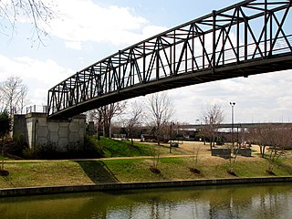
Brown's Island is an artificial island on the James River in Richmond, Virginia, formed by the Haxall Canal. Part of the city's James River Park, it is the popular venue of a large number of outdoor concerts and festivals in the spring and summer, such as the weekly Friday Cheers concert series or Dominion Riverrock. The Rivanna Subdivision Trestle crosses over the island.
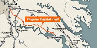
The Virginia Capital Trail (VCT) (informally, the Cap Trail, or simply the Cap) is a dedicated, paved bicycle and pedestrian trail crossing four counties and 51.7 miles (83.2 km) between Jamestown and Richmond, Virginia — that is, between the Colony of Virginia's first capital and Virginia's current capital.
Riverfront Park, branded as Riverfront Spokane, is a public urban park in downtown Spokane, Washington that is owned and operated by the Spokane Parks & Recreation Department. The 100-acre (40 ha) park is situated along the Spokane River and encompasses the Upper Spokane Falls, which is the second largest urban waterfall in the United States.

The James River Parks System is a 600-acre (240 ha) municipal park in Richmond, Virginia. It consists of multiple sections along the James River between the Huguenot Memorial Bridge in the west to a half mile (0.8 km) beyond the I-95 Bridge over the James in the east. It is a part of the city’s Department of Parks, Recreation and Community Facilities.

The Scioto Mile Promenade, also known simply as the Promenade, is a public park and promenade in downtown Columbus, Ohio. The park is part of the Scioto Mile network of parks and trails around the city's downtown area, and has a riverwalk stretching along the east bank of the Scioto River, from Battelle Riverfront Park to Bicentennial Park.

The Great Flood of 1913 severely affected Columbus, Ohio. The area most affected was Franklinton, also known as the Bottoms, for its low elevation near the Scioto River. Among many infrastructure projects, a 7.2-mile floodwall was built from 1993 to 2004 to protect most of Franklinton from flooding.
The Fall Line Trail (FLT) is an approximately 43 mile multi-use trail currently under development — from a northern terminus in Ashland, Virginia to a southern terminus in Petersburg, Virginia.
