Brownlee Tramway (Marlborough)

Last updated

The Brownlee Tramway of Marlborough, New Zealand, (as opposed to the later Bell Hill mill tramway in Westland) was a bush tramway of the Rai and Pelorus Valleys used to take timber from the Carluke Sawmill through to the shipping port and mill of Blackball, Havelock. It operated from c.1881 through to 1915 [1] as part of William Brownlee's (and later his son, John's) extensive sawmilling operation in the area.

Contents

Logs from the lower Opouri Valley to be railed to the Carluke band saw mill, 3-3-1912 (Brownlee Tramway, Marlborough Museum, Marlborough Historical Society).jpg
Logs in lower Opouri Valley to be railed to Carluke band saw mill
Steam locomotive, Opouri, hauling logs down the tramline to the mill at Blackball (Brownlee Tramway, Marlborough Museum, Marlborough Historical Society).jpg
Steam locomotive Opouri hauling logs down to the mill at Blackball
William Brownlee's sawmill at the port of Blackball on a distributary of the Pelorus River, less than 2 km from Havelock (Marlborough Museum, Marlborough Historical Society).jpg
Brownlee's sawmill at Blackball on the Pelorus River

Line

Dalton's bridge over the Pelorus River Looking downstream to Brownlee's bridge over the Pelorus River on the site of the present Dalton's bridge (Brownlee Tramway, Marlborough Museum, Marlborough Historical Society).jpg
Dalton's bridge over the Pelorus River
Map of the route Brownlee Tramway, Marlborough (OpenStreetMap).jpg
Map of the route

The tramway was built to 3 ft 6 in (1,067 mm) gauge, and to a comparatively high standard for the possibility of a government takeover to form a line to Nelson. It totaled 29 kilometres (18 mi) in 1906 [2] and was the only significant tramway in the Marlborough Region. Carluke, a sawmill and settlement near Rai Valley township (named after the Scottish town in which the Brownlee family hailed from) was where the main line began. It headed south through the Rai Valley, and joined the Pelorus River valley on the north side, opposite to the Pelorus River Reserve and Pelorus Bridge. It turned eastwards and followed the Pelorus River until crossing it at 'Dalton's Bridge'. The formation from here now mostly forms part of State Highway 6 until where it crossed the Wakamarina River at Canvastown. An embankment on the east side is still visible today. From here it carried on closely to the main road with some parts having been used by the road since closure until terminating at Blackball. Very little remains at Blackball today except the hull of the abandoned SS Pelorus.

Locomotives

NameMakerMaker's NumberYearTypePhotoNotes
Aunt Sally Barclay 7181892Conventional No.8 Brownlees Mill Carluke Hauling timber to Pelorus (Brownlee Tramway, Marlborough Museum, Marlborough Historical Society).jpg Was built coupled to a log winch, which was powered by the loco with long coupling rods when the wheels were jacked up off the rails. Converted from 0-4-0 to 2-4-2 (and lost the winch) to handle temporary tramway tracks better. A Shanks boiler, saddle tank and cab were fitted in its later life at Ruru. It is now preserved at Havelock Museum. [3]
Opouri Stearns 10631902Geared (Heisler) Brownlee and Co's locomotive Opouri which crashed through the bridge at the present site of Dalton's Bridge over the Pelorus River.jpg Fell into the Pelorus River when the Dalton's Bridge collapsed, 1911. [4] David Young was the driver and was injured so that had 69 days sick leave to recover. Engine unit remains stored at the Bush Tramway Club.
TwinsBarclay1130A1907Conventional Twin locomotive built by Andrew Barclay, Sons and Co (Brownlee Tramway, Marlborough Museum, Marlborough Historical Society).jpg 1130A+B were built as a twin locomotive, which was just two tank engines semi-permanently coupled back to back. They were soon separated and used independently. 1130A stayed with Brownlees working at Ruru on the West Coast and is now preserved in Tauranga. [5]
TwinsBarclay1130B1907Conventional Brownlee and Co's Barclay Duplex crossing Couper's (Cooper's) bridge, Rai Valley (Brownlee Tramway, Marlborough Museum, Marlborough Historical Society).jpg After uncoupling 1130A+B, only 1130B went to the North Island in 1917 and was probably scrapped. [5]

Several self-built internal combustion engine powered trolley was used on the tramway. [6] There were other small locomotives trialed on the tramway as well (see below).

Other Tramways

Brownlee's operated an earlier tramway in the Kaituna Valley south of Havelock in the 1870s. it was not connected to the later Carluke-Blackball tramway. A small vertical boilered loco once worked the line, but did not prove successful. [7]

When the native forest milling rights ran out around the Rai Valley, Brownlee's moved to the West Coast, based in Ruru. William Brownlee was one of the main shareholders of the Lake Brunner Sawmilling Company, and later bought the remaining shares out. [8]

Related Research Articles

<span class="mw-page-title-main">Havelock, New Zealand</span> Town in Marlborough, New Zealand

Havelock is a small town in the Marlborough Region of New Zealand, at the head of Pelorus Sound, one of the Marlborough Sounds, and at the mouth of the Pelorus and Kaituna Rivers

<span class="mw-page-title-main">Pelorus Sound</span> Largest of the Marlborough Sounds, New Zealand

Pelorus Sound is the largest of the sounds which make up the Marlborough Sounds at the north of the South Island, New Zealand.

<span class="mw-page-title-main">Pelorus River</span> River in Marlborough, New Zealand

Te Hoiere / Pelorus River is a river at the northern end of South Island of New Zealand in the region of Marlborough. It flows from the Richmond Range into Pelorus Sound / Te Hoiere. This area is fantastic for camping and is renowned for its magnificent river swimming where the Pelorus River runs through a gorge at Pelorus Bridge.

Ngahere is a locality in the Grey District of the West Coast of New Zealand's South Island. The 2013 New Zealand census gave the population of Ngahere and its surrounding area as 363, an increase of 5.2% or 18 people since the 2006 census. Ngahere is located on the south bank of the Grey River, and State Highway 7 and the Stillwater–Westport Line (SWL) railway pass through the village.

<span class="mw-page-title-main">Powelltown tramway</span> Former tramway in Victoria, Australia

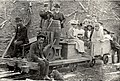
The Powelltown tramway was a 3 ft narrow gauge tramway that operated between Powelltown and Yarra Junction, Victoria, Australia, between 1913 and 1945.

<span class="mw-page-title-main">State Highway 6 (New Zealand)</span> Road in New Zealand

State Highway 6 is a major New Zealand state highway. It extends from the Marlborough region in the northeastern corner of the South Island across the top of the island, then down the length of the island, initially along the West Coast and then across the Southern Alps through inland Otago and finally across the Southland Plains to the island's south coast. Distances are measured from north to south.

<span class="mw-page-title-main">Canvastown</span> Place in Marlborough, New Zealand

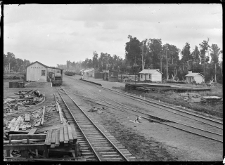
Canvastown is a locality at the point where the Wakamarina River joins the Pelorus River, in Marlborough, New Zealand. State Highway 6 runs through the area. Rai Valley is 17 km to the northwest. Havelock is 10 km to the east.

<span class="mw-page-title-main">Rai Valley</span> Rural settlement in Marlborough, New Zealand

Rai Valley is a rural settlement in Marlborough, New Zealand. It is located on State Highway 6, 68 km (42 mi) northwest of Blenheim and 46 km (29 mi) east of Nelson. The Rai River runs past the locality to join the Pelorus River at the locality of Pelorus Bridge to the south. At the 2018 census, the settlement had a population of 177.

The Rainy River is a short river of the northeastern Marlborough Region of New Zealand's South Island. It flows north from the Richmond Range into the Pelorus River, which it reaches five kilometres west of Pelorus Bridge.

<span class="mw-page-title-main">Pelorus Bridge</span> Place in Marlborough, New Zealand

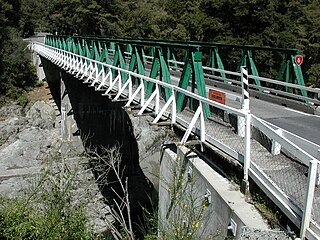
Pelorus Bridge is a tiny locality in Marlborough, New Zealand where the Rai River meets Pelorus River. State Highway 6 crosses the Pelorus River at Pelorus Bridge Scenic Reserve, which was used as one of the film locations for The Hobbit: The Desolation of Smaug. You can take a guided kayak tour to experience this Hobbit filming location.

Elaine Bay is a bay located in Pelorus Sound / Te Hoiere, within the Marlborough Sounds at the north end of the South Island of New Zealand. Elaine Bay is in the Tawhitinui Reach, which includes other bays such as Tennyson Inlet, Fitzroy Bay and Hallum Cove. The bay is accessed by the Elaine Bay Road, which connects with the Croisilles-French Pass Road at the top of the ridge.

<span class="mw-page-title-main">Taringamotu Tramway</span>

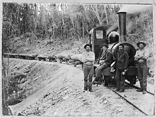
Taringamotu Tramway, nicknamed Taringamotu Express, was a bush tramway near Oruaiwi, also known as Waituhi, a settlement in the valley of Taringamotu in the Manawatū-Whanganui region of New Zealand's North Island. It operated from 1910 to the mid 1960s.

<span class="mw-page-title-main">Bell Hill mill tramway</span>

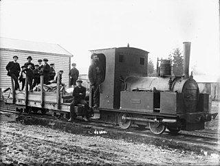
Bell Hill mill tramway was a bush tramway at Bell Hill in the Moana Region of the Grey District on the West Coast of New Zealand. The tramway with a track gauge of 3 ft 6 in was used in the 1910s.

<span class="mw-page-title-main">May Morn Estates Tramway</span> Early Twentieth Century train service in New Zealand

The May Morn Estates Tramway was a bush tramway at Mangaroa, which crossed the Hutt River at Te Mārua near Upper Hutt on New Zealand's North Island. The company was incorporated in 1912 and operated their saw mill at least from 1914 to 1915.

<span class="mw-page-title-main">Takaka Tramway</span>

The Takaka Tramway was a narrow gauge light railway that operated in the Tākaka Valley, Golden Bay, New Zealand, from 1882 to 1905, linking farms and sawmills of the Takaka Valley with the tidal port of Waitapu at the mouth of the Tākaka River.

<span class="mw-page-title-main">Charming Creek Tramway</span>

The Charming Creek Tramway was a 9 kilometres (5.6 mi) long private bush tramway at Ngakawau in Buller District on the West Coast in New Zealand. It was used from 1903 or 1905 to 1958.

<span class="mw-page-title-main">Stuart and Chapman's bush tramway, Rimu</span>

Stuart and Chapman's bush tramway, Rimu was a 20 kilometres (12 mi) long bush tramway with a gauge of probably 2-foot 6-inch (762 mm) at Seddon's Terrace Sawmill in Rimu, New Zealand. It ran south of Ross to the Lake Ianthe area. It was used from at least 1899 to 1962.

<span class="mw-page-title-main">Port Craig tramway</span> Railway line in New Zealand

The Port Craig tramway was an overall 24.4 kilometres (15.2 mi) long, bush tramway with a gauge of 3 ft 6 in at Port Craig in New Zealand, which operated from 1917 to 1928.

<span class="mw-page-title-main">Pokaka railway station</span> Railway station in New Zealand

Pokaka was a station on the North Island Main Trunk line, in the Ruapehu District of New Zealand. It served the small village of Pokaka and lay to the south of Makatote Viaduct, the late completion of which held up opening of the station.

References

  1. "The Brownlees Enterprise". The Prow. Retrieved 11 August 2018.
  2. Yonge, John Roger; Company, Quail Map (1993). New Zealand Railway and Tramway Atlas. Quail Map Company. ISBN   9780900609923.
  3. "Brownlee & Co. No. Unknown-Havelock, New Zealand". Steam Locomotives. Retrieved 12 August 2018.
  4. "Railway accident, Pelorus Marlborough". Marlborough Museum. Retrieved 12 August 2018.
  5. 1 2 "Industrial Locomotives". New Zealand Rolling Stock Register. Retrieved 12 August 2018.
  6. "Outing on a trolly (sic)". Marlborough Museum. Retrieved 12 August 2018.
  7. "Vertical Boiler Steam Locomotive". Marlborough Museum. Retrieved 12 August 2018.
  8. "Chapter 38 – Sawmilling on the West Coast". Victoria – University of Wellington. Retrieved 14 August 2018.

41°16′S173°45′E / 41.27°S 173.75°E / -41.27; 173.75