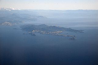
D'Urville Island, Māori name Rangitoto ki te Tonga, is the largest island in the Marlborough Sounds, on the northern coast of the South Island of New Zealand. It was named after the French explorer Jules Dumont d'Urville. With an area of approximately 150 square kilometres (58 sq mi), it is the eighth-largest island of New Zealand, and has around 52 permanent residents. The local authority is the Marlborough District Council.
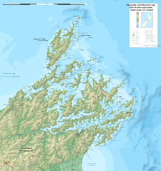
The Marlborough Sounds are an extensive network of sea-drowned valleys at the northern end of the South Island of New Zealand. The Marlborough Sounds were created by a combination of land subsidence and rising sea levels. According to Māori mythology, the sounds are the prows of the many sunken waka of Aoraki.

Marlborough District or the Marlborough Region, commonly known simply as Marlborough, is one of the 16 regions of New Zealand, located on the northeast of the South Island. Marlborough is a unitary authority, both a district and a region. Marlborough District Council is based at Blenheim, the largest town. The unitary region has a population of 52,300.

Havelock is a small town in the Marlborough Region of New Zealand, at the head of Pelorus Sound, one of the Marlborough Sounds, and at the mouth of the Pelorus and Kaituna Rivers

Lake Wakatipu is an inland lake in the South Island of New Zealand. It is in the southwest corner of the Otago region, near its boundary with Southland. Lake Wakatipu comes from the original Māori name Whakatipu wai-māori.

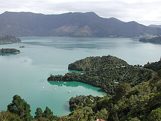
Pelorus Sound is the largest of the sounds which make up the Marlborough Sounds at the north of the South Island, New Zealand.
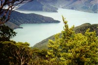
Kenepuru Sound is one of the larger of the Marlborough Sounds in the South Island of New Zealand. The drowned valley is an arm of Pelorus Sound / Te Hoiere, it runs for 25 kilometres (16 mi) from the northeast to southwest, joining Pelorus Sound a quarter of the way down the latter's path to the Cook Strait.
Fairy Bay is east of Mount Stanley, elevation 971 metres (3,186 ft), in Pelorus Sound / Te Hoiere, part of the Marlborough Sounds Maritime Park, at the top of the South Island, New Zealand. The origin of the name is thought to have been the fairy penguin. It has previously been known as Falls River Bay and Sandfly Bay. A neighbouring bay immediately to the south is called Penguin Bay.

Maud Island is one of the larger islands in the Marlborough Sounds on the northeastern tip of the South Island of New Zealand, with a total area of 320 ha.

Tennyson Inlet, is the western arm of Pelorus Sound / Te Hoiere in the Marlborough Sounds. Tennyson Inlet encompasses Duncan Bay to Tawhitinui Reach. This area is about 10 kilometres (6 mi) long. Tarakaipā and Tawhitinui Islands are the two largest islands in the inlet. There are three main settlements which are used mostly for recreation.

State Highway 6 is a major New Zealand state highway. It extends from the Marlborough region in the northeastern corner of the South Island across the top of the island, then down the length of the island, initially along the West Coast and then across the Southern Alps through inland Otago and finally across the Southland Plains to the island's south coast. Distances are measured from north to south.
Ngāti Kuia is a Māori iwi of the Northern South Island in New Zealand. They first settled in the Pelorus Sound / Te Hoiere, and later spread to the Marlborough Sounds, Nelson and Tasman districts to Taitapu on the West Coast, and as far south as the Nelson Lakes National Park. Ngāti Kuia tradition states that their founding tupuna Matua Hautere, a descendant of Kupe, came to Te Waipounamu in his waka Te Hoiere, guided by the kaitiaki Kaikaiawaro.

Canvastown is a locality at the point where the Wakamarina River joins the Pelorus River, in Marlborough, New Zealand. State Highway 6 runs through the area. Rai Valley is 17 km to the northwest. Havelock is 10 km to the east.

Rai Valley is a rural settlement in Marlborough, New Zealand. It is located on State Highway 6, 68 km (42 mi) northwest of Blenheim and 46 km (29 mi) east of Nelson. The Rai River runs past the locality to join the Pelorus River at the locality of Pelorus Bridge to the south. At the 2018 census, the settlement had a population of 177.

French Pass is a narrow and treacherous stretch of water that separates D'Urville Island, at the north end of the South Island of New Zealand, from the mainland coast. At one end is Tasman Bay, and at the other end the outer Pelorus Sound / Te Hoiere leads out to Cook Strait.
Pelorus Bridge is a tiny locality in Marlborough, in New Zealand's South Island, where the Rai River meets Pelorus River. State Highway 6 crosses the Pelorus River at Pelorus Bridge Scenic Reserve, which was used as one of the film locations for The Hobbit: The Desolation of Smaug. You can take a guided kayak tour to experience this Hobbit filming location.
Elaine Bay is a bay located in Pelorus Sound / Te Hoiere, within the Marlborough Sounds at the north end of the South Island of New Zealand. Elaine Bay is in the Tawhitinui Reach, which includes other bays such as Tennyson Inlet, Fitzroy Bay and Hallum Cove. The bay is accessed by the Elaine Bay Road, which connects with the Croisilles-French Pass Road at the top of the ridge.
The history of the Nelson Region of New Zealand dates back to settlement by the Māori people in about the 12th century. The Nelson and Marlborough Region were known to the Māori as Te Tau Ihu o Te Waka a Maui which means "The Prow of the Canoe of Maui".
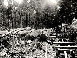
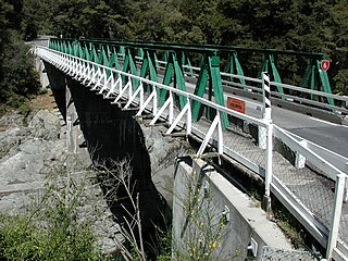
The Brownlee Tramway of Marlborough, New Zealand, was a bush tramway of the Rai and Pelorus Valleys used to take timber from the Carluke Sawmill through to the shipping port and mill of Blackball, Havelock. It operated from c.1881 through to 1915 as part of William Brownlee's extensive sawmilling operation in the area.

