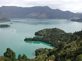
Kenepuru Sound is one of the larger of the Marlborough Sounds in the South Island of New Zealand. The drowned valley is an arm of Pelorus Sound / Te Hoiere, it runs for 25 kilometres (16 mi) from the northeast to southwest, joining Pelorus Sound a quarter of the way down the latter's path to the Cook Strait.
Fairy Bay is east of Mount Stanley, elevation 971 metres (3,186 ft), in Pelorus Sound / Te Hoiere, part of the Marlborough Sounds Maritime Park, at the top of the South Island, New Zealand. The origin of the name is thought to have been the fairy penguin. It has previously been known as Falls River Bay and Sandfly Bay. A neighbouring bay immediately to the south is called Penguin Bay.
Tawero Point marks the eastern limit of the Wilson Bay Farm and the southern approach to Tawhitinui Reach in Pelorus Sound / Te Hoiere, part of the Marlborough Sounds Maritime Park at the top of the South Island of New Zealand. Located at the end of a distinctive land feature easily recognisable on a chart or from the air, Tawero Point is home to a number of hardy Romney Marsh sheep which graze its steep and at times windswept slopes. The point is identified at night by maritime navigation lights on either side of the headland. All vessels leaving the inner sound for the open sea must round Tawero Point.

Maud Island is one of the larger islands in the Marlborough Sounds on the northeastern tip of the South Island of New Zealand, with a total area of 320 ha.
The Charwell River is a river in the northeast of New Zealand's South Island. Its headwaters are in the Seaward Kaikōura Ranges and it feeds into the Conway River, the traditional boundary between Marlborough and Canterbury. Sheep farming has taken place in the Charwell River's valley.

Penzance Bay is a popular bay located in Tennyson Inlet, New Zealand, within the Marlborough Sounds. Tennyson Inlet is an arm of Pelorus Sound / Te Hoiere. The bay is immediately north of Tuna Bay, which is accessed by the same road.
Maungatapu is a mountain in New Zealand located on the border of the Nelson, New Zealand and Marlborough Regions. It lies in the Bryant Range. The mountain is 1014 metres high. Maungatapu is Māori for "sacred mountain". The mountain was the location of the infamous Maungatapu murders.

Rai Valley is a rural settlement in Marlborough, New Zealand. It is located on State Highway 6, 68 km (42 mi) northwest of Blenheim and 46 km (29 mi) east of Nelson. The Rai River runs past the locality to join the Pelorus River at the locality of Pelorus Bridge to the south. At the 2018 census, the settlement had a population of 177.

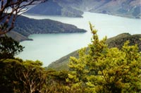
French Pass is a narrow and treacherous stretch of water that separates D'Urville Island, at the north end of the South Island of New Zealand, from the mainland coast. At one end is Tasman Bay, and at the other end the outer Pelorus Sound / Te Hoiere leads out to Cook Strait.
The Lottery River is a river of the north Canterbury region of New Zealand's South Island. It rises on the slopes of Mount Tinline, flowing generally south to meet with the Mason River 5 kilometres (3 mi) northeast of Waiau.

The Rai River is a river of the Tasman Region of New Zealand's South Island. It flows predominantly south, reaching the Pelorus River at Pelorus Bridge. The township of Rai Valley in Marlborough district is located close to the river's banks.

The Wakamarina River is a river of the Marlborough Region of New Zealand's South Island. It flows generally northeast from its origins in the Richmond Range to reach the Pelorus River at the settlement of Canvastown, 10 kilometres (6 mi) west of Havelock. In 1864, gold was found in the river near Havelock, and soon 6,000 men were working in the area. The gold rush did not last long and most miners moved on to the West Coast gold rush.
Admiralty Bay is a large indentation in the northern coast of New Zealand's South Island. It lies close to the northernmost mainland point of the Marlborough Sounds, immediately to the south of D'Urville Island.
The Rainy River is a short river of the northeastern Marlborough Region of New Zealand's South Island. The 790-metre Rainy flows north from the Richmond Range into the Pelorus River, which it reaches five kilometres west of Pelorus Bridge.
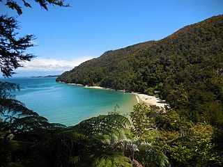
Tinline Bay is a cove and beach located within The Abel Tasman National Park in the South Island of New Zealand.

John Wallis Barnicoat was an English civil engineer and surveyor who emigrated to New Zealand. In his chosen homeland, he became a local politician in Nelson. Towards the end of his life, he was a member of the New Zealand Legislative Council for 19 years.
Elaine Bay is a bay located in Pelorus Sound / Te Hoiere, within the Marlborough Sounds at the north end of the South Island of New Zealand. Elaine Bay is in the Tawhitinui Reach, which includes other bays such as Tennyson Inlet, Fitzroy Bay and Hallum Cove. The bay is accessed by the Elaine Bay Road, which connects with the Croisilles-French Pass Road at the top of the ridge.
Barrington is a minor suburb in the south of Christchurch, New Zealand, occasionally referred to as part of Spreydon. In 2006, the area was classified as a suburb by government organisations such as Statistics New Zealand for the purposes of the census, and divided into two areas named Barrington South and Barrington North. For the 2018 census, the area of Barrington was instead primarily included within the statistical area of Spreydon South.

The Bryant Range is a range of low mountains in the northern South Island of New Zealand. They form part of the boundary of the Nelson and Tasman Districts with Marlborough Region, as well as forming the western boundary of Mount Richmond Forest Park The range is traversed by State Highway 6 at the Rai Saddle close to its northern end.
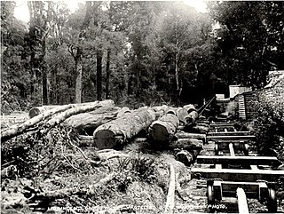
The Brownlee Tramway of Marlborough, New Zealand, was a bush tramway of the Rai and Pelorus Valleys used to take timber from the Carluke Sawmill through to the shipping port and mill of Blackball, Havelock. It operated from c.1881 through to 1915 as part of William Brownlee's extensive sawmilling operation in the area.
