Related Research Articles

Surrey is a city in British Columbia, Canada. It is located south of the Fraser River on the Canada–United States border. It is a member municipality of the Metro Vancouver regional district and metropolitan area. Mainly a suburban city, Surrey is the province's second-largest by population after Vancouver and the third-largest by area after Abbotsford and Prince George. Seven neighbourhoods in Surrey are designated town centres: Cloverdale, Fleetwood, Guildford, Newton, South Surrey, and City Centre encompassed by Whalley.

Delta is a city in the Lower Mainland region of British Columbia, Canada, as part of Greater Vancouver. Located on the Fraser Lowland south of Fraser River's south arm, it is bordered by the city of Richmond on the Lulu Island to the north, New Westminster to the northeast, Surrey to the east, the Boundary Bay and the American pene-exclave Point Roberts to the south, and the Strait of Georgia to the west.

Greater Vancouver, also known as Metro Vancouver, is the metropolitan area with its major urban centre being the city of Vancouver, British Columbia, Canada. The term "Greater Vancouver" describes an area that is roughly coterminous with the region governed by the Metro Vancouver Regional District (MVRD), though it predates the 1966 creation of the regional district. It is often used to include areas beyond the boundaries of the regional district but does not generally include wilderness and agricultural areas that are included within the MVRD.

The Stó꞉lō, alternately written as Sto꞉lo, Stó:lô, or Stó:lõ, historically as Staulo or Stahlo, and historically known and commonly referred to in ethnographic literature as the Fraser River Indians or Lower Fraser Salish, are a group of First Nations peoples inhabiting the Fraser Valley and lower Fraser Canyon of British Columbia, Canada, part of the loose grouping of Coast Salish nations. Stó꞉lō is the Halqemeylem word for "river". The Stó꞉lō are the river people. The first documented reference to these people as "the Stó꞉lō" occurs in Catholic Oblate missionary records from the 1880s. Prior to this, references were primarily to individual tribal groups such as Matsqui, Ts’elxweyeqw, or Sumas.
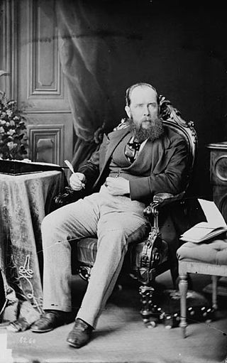
Sir Joseph William Trutch, was an English-born Canadian civil engineer, land surveyor, and politician who served as first Lieutenant Governor of British Columbia.
The Tsleil-Waututh Nation, formerly known as the Burrard Indian Band or Burrard Inlet Indian Band, is a First Nations band government in the Canadian province of British Columbia. The Tsleil-Waututh Nation ("TWN") are Coast Salish peoples who speak hən̓q̓əmin̓əm̓, the Downriver dialect of the Halkomelem language, and are closely related to but politically and culturally separate from the nearby nations of the Sḵwx̱wú7mesh (Squamish) and xʷməθkʷəy̓əm (Musqueam), with whose traditional territories some claims overlap.

The Musqueam Indian Band is a First Nations band government in the Canadian province of British Columbia. It is the only First Nations band whose reserve community lies within the boundaries of the City of Vancouver.
Kwantlen First Nation is a First Nations band government in British Columbia, Canada, located primarily on McMillan Island near Fort Langley. The Kwantlen people traditionally speak hən̓q̓əmin̓əm̓, the Downriver dialect of Halkomelem, one of the Salishan family of languages.
The Brunette River runs through East Burnaby, New Westminster and Coquitlam, flowing out of Burnaby Lake and to the Fraser River. It is the final outflow of the Central Valley Watershed, which consists of most streams between the Ulksen and Burnaby Heights. According to a map and materials by Heritage Advisory Committee and Environment and Waste Management Committee of the City of Burnaby (1993), the number of native campsites discovered on the shores of the Fraser River, Burrard Inlet and Deer Lake and some petroglyphs suggest that the area was used extensively by local aboriginal peoples such as the Squamish, Musqueam and Kwantlen for hunting and fishing before the arrival of European settlers.
McMillan Island is an island in the Fraser River, British Columbia, Canada, also known as McMillan Slough..
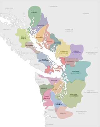
The Coast Salish is a group of ethnically and linguistically related Indigenous peoples of the Pacific Northwest Coast, living in the Canadian province of British Columbia and the U.S. states of Washington and Oregon. They speak one of the Coast Salish languages. The Nuxalk nation are usually included in the group, although their language is more closely related to Interior Salish languages.

The Tsawwassen First Nation is a First Nations government whose lands are located in the Greater Vancouver area of the Lower Mainland of British Columbia, Canada, close to the South Arm of the Fraser River and just north of the international boundary with the United States at Point Roberts, Washington. Tsawwassen First Nation lists its membership at 491 people, nearly half of whom live on the lands.
Semiahmoo First Nation is the band government of the Semiahmoo people, a Coast Salish subgroup. The band's main community and offices are located on the 312 acres (1.3 km2) Semiahmoo Indian Reserve which is sandwiched between the boundary of White Rock, British Columbia and the Canada–United States boundary and Peace Arch Provincial Park.
Poplar Island is an uninhabited island located at the east end of the northern arm of the Fraser River in the City of New Westminster, British Columbia. It is the last large undiked island in the Fraser River's North Arm.
Matsqui is a former district municipality in British Columbia, Canada. It was incorporated in 1892 and merged with the district municipality of Abbotsford in 1995 to create the new City of Abbotsford. Matsqui used to be the western part of what is now Abbotsford. It had commercial growth in the Clearbrook area which then spilled over to Abbotsford.
The New Westminster Indian Band is an Indian Act band government based at suite 105 - 3680 Rae Avenue in Vancouver, British Columbia. The band administration uses the unofficial name "Qayqayt First Nation" in its public communication. The New Westminster Indian Band is one of the smallest First Nations in Canada and the only one registered without a land base.
Milner is a rural village and locality in the Township of Langley in the Fraser Valley of British Columbia, Canada. It is located along the British Columbia Electric Railway line northeast of the City of Langley and just southwest of Fort Langley.
Ebenezer Brown was an English-born wholesale merchant and political figure in British Columbia. He represented New Westminster from 1875 to 1878 and New Westminster City from 1878 to 1881 in the Legislative Assembly of British Columbia.
Qayqayt was the name of an indigenous community located in the Brownsville area of Surrey, British Columbia. The community was part of the Kwantlen First Nation and Musqueam Indian band respectively. It was used as a site for fishing by many different First Nations, including the Kwantlen, Musqueam, Squamish, Katzie, Kwikwetlem, Semiahmoo, Tsleil-waututh, and Tsawwassen.
References
- ↑ BC Names entry "Brownsville (former locality)"
- ↑ letter from John C. Brown, another former MLA, January 14 1927, quoted in Place Names of the Delta of the Fraser River, Denys Nelson, 1927, unpublished manuscript held in the Provincial Archives, quoted in BC Names entry "Brownsville (former locality)"]
- ↑ BC Names entry "qiqéyt (former Indian village)"
- ↑ [Place Names of the Delta of the Fraser River, Denys Nelson, 1927, unpublished manuscript held in the Provincial Archives, quoted in BC Names "Brownsville (former locality)"
- ↑ BC Names entry "Qiqayt (former Indian village)"
- ↑ BC Names entry "Brownsville (railway point)"