
Somerset is a county in South West England which borders Gloucestershire and Bristol to the north, Wiltshire to the east, Dorset to the south-east and Devon to the south-west. It is bounded to the north and west by the Severn Estuary and the Bristol Channel, its coastline facing southeastern Wales. Its traditional border with Gloucestershire is the River Avon. Somerset is currently formed of six council areas, of which two are unitary authorities, until the four second-tier district councils are merged on 1 April 2023, after which the county will comprise three unitary authorities. Its county town is Taunton.

Bridgwater is a historic market town and civil parish in Somerset, England. The population was estimated at 41,276 in 2022. Bridgwater is at the edge of the Somerset Levels, in level and well-wooded country. The town lies along both sides of the River Parrett; it has been a major inland port and trading centre since the industrial revolution. Most of its industrial bases still stand today. Its larger neighbour, Taunton, is linked to Bridgwater via a canal, the M5 motorway and the GWR railway line.

Glastonbury is a town and civil parish in Somerset, England, situated at a dry point on the low-lying Somerset Levels, 23 miles (37 km) south of Bristol. The town, which is in the Mendip district, had a population of 8,932 in the 2011 census. Glastonbury is less than 1 mile (2 km) across the River Brue from Street, which is now larger than Glastonbury.

Street is a large village and civil parish in Somerset, England, with a population of 11,805 in 2011. On a dry spot in the Somerset Levels, at the end of the Polden Hills, it is two miles southwest of Glastonbury. There is evidence of Roman occupation. Much of the history of the village is dominated by Glastonbury Abbey, and a 12th-century causeway from Glastonbury built to transport local Blue Lias stone to it.

Frome is a town and civil parish in eastern Somerset, England. The town is built on uneven high ground at the eastern end of the Mendip Hills, and centres on the River Frome. The town, about 13 miles (21 km) south of Bath, is the largest in the Mendip district of Somerset and is part of the parliamentary constituency of Somerton and Frome. The population was 28,559 in 2021.

Somerton is a town and civil parish in the English county of Somerset. It gave its name to the county and was briefly, around the start of the 14th century, the county town, and around 900 was possibly the capital of Wessex. It has held a weekly market since the Middle Ages, and the main square with its market cross is today popular with visitors. Situated on the River Cary, approximately 8.8 miles (14.2 km) north-west of Yeovil, Somerton has its own town council serving a population of 4,697 as of 2011.
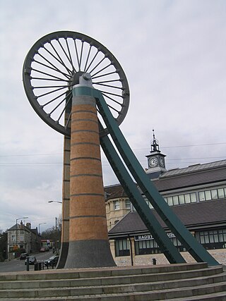
Radstock is a town and civil parish on the northern slope of the Mendip Hills in Somerset, England, about 9 miles (14 km) south-west of Bath and 8 miles (13 km) north-west of Frome. It is within the area of the unitary authority of Bath and North East Somerset. The Radstock built-up area had a population of 9,419 at the 2011 Census.
Chard is a town and a civil parish in the English county of Somerset. It lies on the A30 road near the Devon and Dorset borders, 15 miles (24 km) south west of Yeovil. The parish has a population of approximately 13,000 and, at an elevation of 121 metres (397 ft), Chard is the southernmost and one of the highest towns in Somerset. Administratively Chard forms part of the district of South Somerset.

Wellington is a market town in rural Somerset, a county in the west of England, situated 7 miles (11 km) south west of Taunton in the Somerset West and Taunton district, near the border with Devon, which runs along the Blackdown Hills to the south of the town. The town has a population of 14,549, which includes the residents of the parish of Wellington Without, and the villages of Tone and Tonedale.

Castle Cary is a market town and civil parish in south Somerset, England, 5 miles (8 km) north west of Wincanton and 8 miles (12.9 km) south of Shepton Mallet, at the foot of Lodge Hill and on the River Cary, a tributary of the Parrett.
Crewkerne is a town and electoral ward in Somerset, England, 9 miles (14 km) southwest of Yeovil and 7 miles (11 km) east of Chard all in the South Somerset district. The civil parish of West Crewkerne includes the hamlets of Coombe, Woolminstone and Henley – and borders the county of Dorset to the south. The town is on the main headwater of the River Parrett, A30 road and West of England Main Line railway, in modern times the slower route between the capital and the southwest peninsula, having been eclipsed by the Taunton route.

Wincanton is a small town and electoral ward in South Somerset, southwest England. The town lies off the A303 road, a main route between London and South West England, and has some light industry. The town and electoral ward has a population of 5,272.
Congresbury is a village and civil parish on the northwestern slopes of the Mendip Hills in North Somerset, England, which in 2011 had a population of 3,497. It lies on the A370 between Junction 21 of the M5 and Bristol Airport, 13 miles (21 km) south of Bristol city centre, and 7 miles (11 km) east of Weston-super-Mare. The Congresbury Yeo river flows through the village. The parish includes the hamlet of Brinsea.
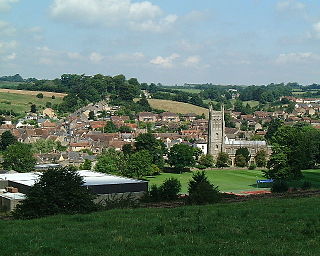
Bruton is a market town, electoral ward, and civil parish in Somerset, England, on the River Brue and the A359 between Frome and Yeovil. It is 7 miles south-east of Shepton Mallet, just south of Snakelake Hill and Coombe Hill, 10 miles north-west of Gillingham and 12 miles south-west of Frome in South Somerset district. The town and ward have a population of 2,907. The parish includes the hamlets of Wyke Champflower and Redlynch. Bruton has a museum of items from the Jurassic era onwards.

Bishop Sutton is a village on the northern slopes of the Mendip Hills, within the affluent Chew Valley in Somerset. It lies east of Chew Valley Lake and north east of the Mendip Hills, approximately ten miles south of Bristol on the A368, Weston-super-Mare to Bath road between West Harptree and Chelwood. Bishop Sutton and the neighbouring village of Stowey form the civil parish of Stowey Sutton.

Sparkford is a village and civil parish in the South Somerset district of Somerset, England. The parish includes the village of Weston Bampfylde.

South Petherton is a village and civil parish in the South Somerset district of Somerset, England, located 5 miles (8 km) east of Ilminster and 5 miles (8 km) north of Crewkerne. The parish had a population of 3,367 in 2011 and includes the smaller village of Over Stratton and the hamlets of Compton Durville, Drayton, Wigborough and Yeabridge. The River Parrett forms the eastern boundary of the parish. The village is approximately 2 miles (3 km) from East Lambrook, Martock and Lopen.

The Bruton Dovecote is a limestone tower that was built between the 15th and 17th century in Bruton in the English county of Somerset. The structure was once used as a dovecote, and may have been a watchtower or prospect tower prior to this. It is a Grade II* listed building and scheduled monument.

