The Allegheny River is a 325-mile-long (523 km) headwater stream of the Ohio River that is located in western Pennsylvania and New York in the United States. It runs from its headwaters just below the middle of Pennsylvania's northern border, northwesterly into New York, then in a zigzag southwesterly across the border and through Western Pennsylvania to join the Monongahela River at the Forks of the Ohio at Point State Park in Downtown Pittsburgh, Pennsylvania.

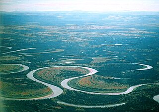
An oxbow lake is a U-shaped lake or pool that forms when a wide meander of a river is cut off, creating a free-standing body of water. The word "oxbow" can also refer to a U-shaped bend in a river or stream, whether or not it is cut off from the main stream.

The Ramapo River is a tributary of the Pompton River, approximately 30 mi (48 km) long, in southern New York and northern New Jersey in the United States.

Canadarago Lake is a 1,917-acre (7.76 km2) lake located in Otsego County, New York and is the source of Oaks Creek. The Village of Richfield Springs is located at the lake's northern end. It is the second largest lake in Otsego County, lying to the west of and parallel to the larger Otsego Lake. The lake's name is also spelled "Candajarago Lake" or "Caniadaraga Lake".

The Laurentide ice sheet was a massive sheet of ice that covered millions of square miles, including most of Canada and a large portion of the Northern United States, multiple times during the Quaternary glacial epochs, from 2.58 million years ago to the present.
Cayuta Creek (Kay-YOO-tuh) is a tributary of the Susquehanna River that flows through Schuyler, Chemung and Tioga counties in New York state, and Bradford County, Pennsylvania.

The Sacandaga River is a 64-mile-long (103 km) river in the northern part of New York in the United States. Its name comes from the Native American Sa-chen-da'-ga, meaning "overflowed lands".

The Saranac River is an 81-mile-long (130 km) river in the U.S. state of New York.

The North Branch of the Millers River is a river in southwestern New Hampshire and northern Massachusetts in the United States. It is a tributary of the Millers River, which flows west to the Connecticut River, which in turn flows south to Long Island Sound, an arm of the Atlantic Ocean.

Wappinger Creek is a 41.7-mile-long (67.1 km) creek which runs from Thompson Pond to the Hudson River at New Hamburg in Dutchess County, New York, United States. It is the longest creek in Dutchess County, with the largest watershed in the county.

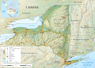
The geography of New York varies widely across the state. Most of New York is dominated by farms, forests, rivers, mountains, and lakes. New York's Adirondack Park is larger than any U.S. National Park in the contiguous United States. Niagara Falls, on the Niagara River as it flows from Lake Erie to Lake Ontario, is a popular attraction. The Hudson River begins near Lake Tear of the Clouds and flows south through the eastern part of the state without draining lakes George or Champlain. Lake George empties at its north end into Lake Champlain, whose northern end extends into Canada, where it drains into the Richelieu River and then the St. Lawrence. Four of New York City's five boroughs are on the three islands at the mouth of the Hudson River: Manhattan Island, Staten Island, and Brooklyn and Queens on Long Island.

Otego Creek is a 32.7-mile-long (52.6 km) tributary of the Susquehanna River in Otsego County, New York. Otego Creek rises in the Town of Otsego and flows south through the Towns of Hartwick and Laurens, before joining the Susquehanna River southwest of the City of Oneonta.

The Cedar River is a 38.5-mile-long (62.0 km) river in the central Adirondacks, in Hamilton County, New York. It rises at the outlet of Cedar Lake in the Town of Arietta and flows northeast into the Town of Lake Pleasant, where it passes through the Cedar River Flow. Continuing northeast and east, it passes through the Town of Indian Lake and remote corners of the Towns of Minerva and Newcomb to join the Hudson River northeast of the hamlet of Indian Lake. The Northville-Placid Trail goes past the Cedar Lakes and along the Cedar River to the flow.

Beaver Dam Lake is a census-designated place (CDP) in the towns of New Windsor, Blooming Grove, and Cornwall in Orange County, New York, United States. As of the 2020 census, it had a population of 2,609.
Lime Lake is a hamlet and census-designated place (CDP) in the northeast part of the town of Machias, in Cattaraugus County, New York, United States. As of the 2010 census, it had a population of 867. Prior to the 2010 census, the area was delineated as part of the Lime Lake-Machias CDP.

West Branch Sacandaga River is a river in Hamilton County in the state of New York. It begins northwest of Benson and flows west then northward then eastward before converging with the Sacandaga River south of Wells.

Piseco Lake is located in Hamilton County, New York, near the hamlet of Piseco in the Adirondack Mountains. The outflow is Piseco Outlet, which flows into the West Branch Sacandaga River. In the early 1800s Joshua Brown, who was a surveyor in the area, named the lake after a Native American named "Pezeeko" who lived on the lake.
Red House Hill is a mountain in the Central New York Region of the State of New York, United States. It is located south-southwest of the Hamlet of Springfield Center, New York, west of Hutter Point and Six Mile Point of Otsego Lake, and southeast of Rum Hill. Mohican Brook flows eastward along the southern edge of the hill.

Indian River is a river in Hamilton County and Essex County in the U.S. State of New York. Indian River begins at Indian Lake south of the Hamlet of Indian Lake and flows northeastward, through Lake Abanakee, before converging with the Hudson River northeast of the Hamlet of Indian Lake.


