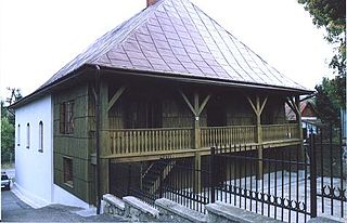
Bobowa is a town in the Gorlice County, Poland. Administratively attached to the Lesser Polish Voivodeship, it is located 18 kilometres from Gorlice, on the Biała Tarnowska river. It was formerly a village, granted town status on 1 January 2009. It lies west of Gorlice and 83 km (52 mi) south-east of the regional capital Kraków. Bobowa is located along Regional Road nr 981, it also has a rail station on the electrified line which goes from Tarnów to the border with Slovakia at Leluchów.
Gmina Łużna is a rural gmina in Gorlice County, Lesser Poland Voivodeship, in southern Poland. Łużna is located approximately 11 kilometres (7 mi) north-west of Gorlice and 89 km (55 mi) south-east of the regional capital Kraków.

Tanica Dolna is a village in the administrative district of Gmina Michałowo, within Białystok County, Podlaskie Voivodeship, in north-eastern Poland, close to the border with Belarus. It lies approximately 13 kilometres (8 mi) south-east of Michałowo and 42 km (26 mi) south-east of the regional capital Białystok.

Dolna Niwa is a village in the administrative district of Gmina Biecz, within Gorlice County, Lesser Poland Voivodeship, in southern Poland. It lies approximately 6 kilometres (4 mi) south-west of Biecz, 7 km (4 mi) north-east of Gorlice, and 101 km (63 mi) south-east of the regional capital Kraków.

Berdechów is a village in the administrative district of Gmina Bobowa, within Gorlice County, Lesser Poland Voivodeship, in southern Poland. It lies approximately 3 kilometres (2 mi) north of Bobowa, 19 km (12 mi) north-west of Gorlice, and 82 km (51 mi) south-east of the regional capital Kraków.

Jankowa is a village in the administrative district of Gmina Bobowa, within Gorlice County, Lesser Poland Voivodeship, in southern Poland. It lies approximately 3 kilometres (2 mi) west of Bobowa, 20 km (12 mi) west of Gorlice, and 80 km (50 mi) south-east of the regional capital Kraków.

Sędziszowa is a village in the administrative district of Gmina Bobowa, within Gorlice County, Lesser Poland Voivodeship, in southern Poland. It lies approximately 4 kilometres (2 mi) north-east of Bobowa, 18 km (11 mi) north-west of Gorlice, and 83 km (52 mi) south-east of the regional capital Kraków.

Siedliska is a village in the administrative district of Gmina Bobowa, within Gorlice County, Lesser Poland Voivodeship, in southern Poland. It lies approximately 5 kilometres (3 mi) north-east of Bobowa, 16 km (10 mi) north-west of Gorlice, and 84 km (52 mi) south-east of the regional capital Kraków.

Stróżna is a village in the administrative district of Gmina Bobowa, within Gorlice County, Lesser Poland Voivodeship, in southern Poland. It lies approximately 4 kilometres (2 mi) east of Bobowa, 14 km (9 mi) west of Gorlice, and 86 km (53 mi) south-east of the regional capital Kraków.

Wilczyska is a village in the administrative district of Gmina Bobowa, within Gorlice County, Lesser Poland Voivodeship, in southern Poland. It lies approximately 4 kilometres (2 mi) south of Bobowa, 17 km (11 mi) west of Gorlice, and 84 km (52 mi) south-east of the regional capital Kraków.

Kwiatonowice is a village in the administrative district of Gmina Gorlice, within Gorlice County, Lesser Poland Voivodeship, in southern Poland. It lies approximately 8 kilometres (5 mi) north of Gorlice and 95 km (59 mi) south-east of the regional capital Kraków.

Stróżówka is a village in the administrative district of Gmina Gorlice, within Gorlice County, Lesser Poland Voivodeship, in southern Poland. It lies approximately 5 kilometres (3 mi) north-west of Gorlice and 96 km (60 mi) south-east of the regional capital Kraków.

Kasinka Mała is a village in the administrative district of Gmina Mszana Dolna, within Limanowa County, Lesser Poland Voivodeship, in southern Poland. It lies approximately 7 kilometres (4 mi) north-west of Mszana Dolna, 29 km (18 mi) west of Limanowa, and 39 km (24 mi) south of the regional capital Kraków.

Stańkowa is a village in the administrative district of Gmina Łososina Dolna, within Nowy Sącz County, Lesser Poland Voivodeship, in southern Poland. It lies approximately 7 kilometres (4 mi) south-west of Łososina Dolna, 15 km (9 mi) north-west of Nowy Sącz, and 59 km (37 mi) south-east of the regional capital Kraków.

Świdnik is a village in the administrative district of Gmina Łososina Dolna, within Nowy Sącz County, Lesser Poland Voivodeship, in southern Poland. It lies approximately 5 kilometres (3 mi) south-west of Łososina Dolna, 13 km (8 mi) north-west of Nowy Sącz, and 61 km (38 mi) south-east of the regional capital Kraków.

Grudna Dolna is a village in the administrative district of Gmina Brzostek, within Dębica County, Subcarpathian Voivodeship, in south-eastern Poland. It lies approximately 7 kilometres (4 mi) north-east of Brzostek, 14 km (9 mi) south of Dębica, and 42 km (26 mi) west of the regional capital Rzeszów.

Opinogóra Dolna is a village in the administrative district of Gmina Opinogóra Górna, within Ciechanów County, Masovian Voivodeship, in east-central Poland. It lies approximately 2 kilometres (1 mi) north of Opinogóra Górna, 8 km (5 mi) north-east of Ciechanów, and 80 km (50 mi) north of Warsaw.


