Centrul Civic is a district in central Bucharest, Romania, which was completely rebuilt in the 1980s as part of the scheme of systematization under the dictator Nicolae Ceauşescu.

The University of Bucharest, commonly known after its abbreviation UB in Romania, is a public university founded in 1864 by decree of Prince Alexandru Ioan Cuza to convert the former Saint Sava Academy into the current University of Bucharest, making it the second oldest modern university in Romania. It is one of the five members of the Universitaria Consortium.

Ferentari[fe.renˈtarʲ] is a neighbourhood located in the 5th Sector of Bucharest, Romania.

Eroilor is a metro station in Bucharest. It is located near the Cotroceni neighbourhood, servicing the Bucharest Metro lines M1 and M3. Notable buildings in its vicinity are the Bucharest Opera house, the Bucharest Opera Business Center, the Bucharest Law School, the Carol Davila University of Medicine and Pharmacy, the University Hospital of Bucharest, one of the buildings of the Bucharest University of Veterinary Medicine and the Saint Elefterie Church.

Titan is a metro station in Bucharest located in the Titan district. The station services the now rather obsolete shopping center, the large Titan Park and the district's dense population.
Dimitrie Leonida, formerly known as IMGB is a metro station in southern Bucharest, on Line 2. The station was originally built in order to transport workers to the Kvaerner IMGB steelworks. Even though this purpose is still served today to an extent, the area around the steelworks has developed residentially, and therefore is used by commuters who work in the city centre of Bucharest.
Berceni, formerly known as Depoul IMGB is a metro station in Bucharest, Romania. It is the southern terminal station of Bucharest Metro Line M2 and it is the only aboveground metro station of Bucharest Metro as of 2013. This station is in the suburbs of Bucharest in Ilfov County.

Pipera is a district of Voluntari city, situated in the north part of Bucharest, Romania.

The Bucharest Ring was a street circuit in the Romanian capital city of Bucharest and was initiated by City Challenge GmbH.

Victoriei Square is a major intersection in central Bucharest, where Calea Victoriei, Lascăr Catargiu Boulevard, Iancu de Hunedoara Boulevard, Kiseleff Boulevard, Ion Mihalache Boulevard and Nicolae Titulescu Boulevard cross. It is known for its proximity to major office towers and government buildings. The main government building dates back as far as 1937, when construction work for it started, but it was only completed in 1950. In 1987, the neighboring apartment buildings and Victoria Underpass were built, the underpass was completed sometime between 1987-1989 and the apartment buildings in 1992-1994.
Apartment Building 63, also called Commune 63 is an apartment building located in the Dristor neighbourhood in the south-eastern part of Bucharest and it is the largest single residential building in Romania with a total of 950 apartments, with one room, and holding just over 1,600 residents. The building is nicknamed the commune because of the large number of apartments that could house an entire village or commune, and because of the long corridors that stretch from one end of the building to the other and resemble a long country road. The apartment building has four staircases of 10 floors each and is built in the shape of a giant Z with an extension in the southern part of the structure. It is also located near the Dristor metro station, a major node of the Bucharest Metro's railway network.

Asmita Gardens is a residential complex located in Bucharest. The complex has a total surface of 70,000 m2 and is formed by a total of seven towers, five of which have a height of 16 floors, one tower with a height of 20 floors, and one tower with a height of 24 floors. At 92.2 m (302 ft), the 24 floor tower T3 is the tallest residential building in Bucharest.
Carlton Bloc was a residential bloc located in Bucharest, Romania. at 9 Nicolae Bălcescu Boulevard, completed in 1936. Designed by architects George Matei Cantacuzino and Vasile Arion, it had a large cinema on the ground level, also called the Carlton. Having 14 floors, and a height of 47 metres (154 ft) it was the tallest buildings in the capital until it completely collapsed in the November 10, 1940 earthquake, killing 140 and injuring 86 people.
BSE Tower or Bucharest Stock Exchange Tower is an office building located in the city of Bucharest, Romania. It has 16 floors and a surface of 14,000 m2. The building is the headquarters of the Bucharest Stock Exchange.

Hotel Pullman Bucharest World Trade Center is a hotel building located in Bucharest. It has 12 floors and a surface of 18,000 m2. Its building is connected to the World Trade Center. The hotel building formerly operated under the Sofitel brand.

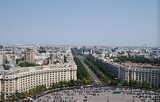
Bulevardul Unirii is a major thoroughfare in central Bucharest, Romania. It connects Alba Iulia Square with Constitution Square, and also runs through Unification Square. The Constitution Square end features the Palace of the Parliament, which began construction simultaneously with the boulevard as an architectural unit.

Crystal Tower is a class A office building located on the Lancu de Hunedoara Boulevard in Bucharest, Romania. The building has 15 floors, a height of 72 m (236 ft) and a surface of 24,728 m2 (266,170 sq ft). The Crystal Tower was the first private office building in Bucharest that was built with a heliport, and it serves as the headquarters of the Dutch banking group ING.

Floreasca is a district in Bucharest, Romania, in Sector 2. Its name comes from Lake Floreasca, which is situated in the north of the neighborhood. The Floreasca Hospital is also situated in the neighborhood, in its southern part. Floreasca is considered an upper class area.


