
The Ohio River is a 981-mile (1,579 km) long river in the United States. It is located at the boundary of the Midwestern and Southern United States, flowing southwesterly from western Pennsylvania south of Lake Erie to its mouth on the Mississippi River at the southern tip of Illinois. It is the third largest river by discharge volume in the United States and the largest tributary by volume of the north-south flowing Mississippi River that divides the eastern from western United States. The river flows through or along the border of six states, and its drainage basin includes parts of 14 states. Through its largest tributary, the Tennessee River, the basin includes several states of the southeastern U.S. It is the source of drinking water for three million people.
Washington County is a county located in the U.S. state of Ohio. As of the 2010 census, the population was 61,778. Its county seat is Marietta. The county, the oldest in the state, is named for George Washington.

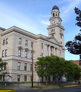
Zanesville is a city in and the county seat of Muskingum County, Ohio, United States. It is located 52 miles (84 km) east of Columbus and had a population of 25,487 as of the 2010 census. Historically the state capital of Ohio, Zanesville anchors the Zanesville micropolitan statistical area, and is part of the greater Columbus-Marion-Zanesville combined statistical area.

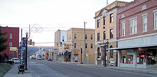
Lowell is a village in Washington County, Ohio, United States, along the Muskingum River. The population was 549 at the 2010 census.

Marietta is a city in, and the county seat of, Washington County, Ohio, United States. During 1788, pioneers to the Ohio Country established Marietta as the first permanent settlement of the new United States in the Territory Northwest of the River Ohio. Marietta is located in southeastern Ohio at the mouth of the Muskingum River at its confluence with the Ohio River 11 miles northeast of Parkersburg, West Virginia. The population was 14,085 at the 2010 census.
St. Marys is a city and the county seat of Pleasants County, West Virginia, United States. The population was 1,860 at the 2010 census. St. Marys was established in 1849 by Alexander Creel, who is said to have had a vision of Mary while passing the townsite by boat on the Ohio River.
Parkersburg is a city in and the county seat of Wood County, West Virginia, United States. Located at the confluence of the Ohio and Little Kanawha rivers, it is the state's fourth-largest city and the largest city in the Parkersburg-Marietta-Vienna metropolitan area. The population was 31,492 at the 2010 census. The city is about 14 miles south of Marietta, Ohio.
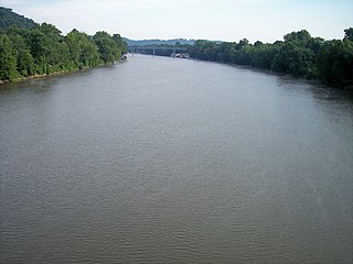
The Muskingum River is a tributary of the Ohio River, approximately 111 miles (179 km) long, in southeastern Ohio in the United States. An important commercial route in the 19th century, it flows generally southward through the eastern hill country of Ohio. Via the Ohio, it is part of the Mississippi River watershed. The river is navigable for much of its length through a series of locks and dams.

The Great Dismal Swamp is a large swamp in the Coastal Plain Region of southeastern Virginia and northeastern North Carolina, between Norfolk, Virginia, and Elizabeth City, North Carolina. It is located in parts of the southern Virginia independent cities of Chesapeake and Suffolk and northern North Carolina counties of Gates, Pasquotank, and Camden. Some estimates place the size of the original swamp at over one million acres (4,000 km2).

The Detroit River International Wildlife Refuge is the only international wildlife refuge in North America. Established in 2001 and managed jointly by the United States Fish and Wildlife Service and the Canadian Wildlife Service, it is located in a major metropolitan area. The Detroit River International Wildlife Refuge is one of over 540 National Wildlife Refuges managed by the U.S. Fish and Wildlife Service within the Department of the Interior. It occupies 7.88 square miles (20.41 km2) of scattered property but has drawn boundaries for further expansion.
Gallipolis Island is an island on the Ohio River along the bank at Gallipolis, Ohio and across from Mason County, West Virginia, USA.

Muskingum Island is a long narrow bar island on the Ohio River in Wood County, West Virginia between the towns of Moore Junction, Ohio and Boaz, West Virginia. The island is mostly covered in forests and contains a number of oil wells.

The Big Bottom massacre occurred on January 2, 1791, near present-day Stockport now in Morgan County, Ohio, United States. It is considered part of the Northwest Indian Wars, in which aboriginal Americans in the Ohio Country confronted American settlers, regular soldiers and militia, seeking to expel them from their territory.

The Ohio River Islands National Wildlife Refuge (ORINWR) is a National Wildlife Refuge (NWR) in non-contiguous sites consisting of islands along 392 miles (631 km) of the Ohio River, primarily in the U.S. state of West Virginia. There are also two islands upstream in Beaver County, Pennsylvania, and a pair downstream in Lewis County, Kentucky. Going downstream, the refuge is currently located in parts of these counties: Beaver, Brooke, Ohio, Marshall, Wetzel, Tyler, Pleasants, Wood, Jackson, Mason, and Lewis. All counties are in West Virginia, with the exceptions in Pennsylvania and Kentucky mentioned above. The ORINWR was established in 1990 and consists of 3,354 acres (13.57 km2) of land and underwater habitat on 22 islands and four mainland properties. The refuge headquarters and visitor center is located in Williamstown, West Virginia. Prior to its establishment, West Virginia was the only state of the United States without a NWR.
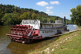
W. P. Snyder Jr., also known as W. H. Clingerman, W. P. Snyder Jr. State Memorial, or J. L. Perry, is a historic towboat moored on the Muskingum River in Marietta, Ohio, at the Ohio River Museum. A National Historic Landmark, she is the only intact, steam-driven sternwheel towboat still on the nation's river system.

The Putnam Street Bridge, also known as the Marietta Bridge, is a historic United States river crossing that connects Marietta, Ohio, with its Fort Harmar district. The original 1880 bridge was the first free crossing of the Muskingum River. The 1913 bridge was a contributing structure to the Harmar Historic District. The bridge crosses the Muskingum, just above its confluence with the Ohio River.

Fort Harmar was an early United States frontier military fort, built in pentagonal shape during 1785 at the confluence of the Ohio and Muskingum rivers, on the west side of the mouth of the Muskingum River. It was built under the orders of Colonel Josiah Harmar, then commander of the United States Army, and took his name. The fort was intended for the protection of Indians, i.e., to prevent pioneer squatters from settling in the land to the northwest of the Ohio River. "The position was judiciously chosen, as it commanded not only the mouth of the Muskingum, but swept the waters of the Ohio, from a curve in the river for a considerable distance both above and below the fort." It was the first frontier fort built in Ohio Country.

Harmar is a historic neighborhood in the city of Marietta, Ohio, United States. Located at the western side of the confluence of the Muskingum and Ohio Rivers, it grew up around the early Fort Harmar in the 1780s, being settled in conjunction with Marietta. After a period of forming part of Marietta, it existed separately beginning in 1837 before rejoining the mother city in 1890. Connected by bridge to the rest of the city, it retains much of its nineteenth-century architecture and landscape, and most of the neighborhood is now a historic district on the National Register of Historic Places.

The Marietta Historic District is a historic district in Marietta, Ohio, United States that is listed on the National Register of Historic Places. Among the buildings in the district are ones dating back to 1788, the year in which Marietta was founded as the first white settlement in what is now Ohio. Among its most significant buildings are the Rufus Putnam House and the Ohio Company Land Office, which are also separately listed on the Register.

The Ohio Rural Intercity Bus Program, branded as GoBus, is a fixed-route intercity bus service operating in the U.S. state of Ohio with funding from the Ohio Department of Transportation. It connects Athens, Ohio and Ohio University to Columbus, Ohio, Cincinnati, Ohio, Cleveland, Ohio, and other cities. GoBus is administered by Hocking-Athens-Perry Community Action Programs (HAPCAP) under its transportation division.
