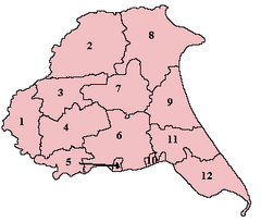
Buckrose was a wapentake of the historic East Riding of Yorkshire, England consisting of the north-west part of the county; its territory is now partly in the modern East Riding and partly in North Yorkshire. Established in medieval times, it ceased to have much significance in the 19th century when the wapentakes were succeeded by other administrative divisions for most local government purposes. Buckrose was formed from parishes of earlier wapentakes, including some from the Domesday-era wapentake of Toreshou. [1]
Buckrose consisted of the parishes of Acklam, Birdsall, Bugthorpe, Burythorpe, Cowlam, Fridaythorpe, Helperthorpe, Heslerton, Kirby Grindalythe, Kirby Underdale, Langton, North Grimston, Norton, Rillington, Scrayingham, Settrington, Sherburn, Skirpenbeck, Sledmere, Thorpe Bassett, Weaverthorpe, Westow, Wetwang, Wharram-le-Street, Wharram Percy, Wintringham and Yedingham. The only town in the wapentake was Norton. [2]
Buckrose gave its name to a parliamentary constituency which existed from 1885 to 1950; however, the Buckrose constituency extended well beyond the boundaries of the wapentake, and in fact took most of its electorate from towns in the neighbouring Dickering and Harthill wapentakes.
The North Riding of Yorkshire is a subdivision of Yorkshire, England, alongside York, the East Riding and West Riding. The riding's highest point is at Mickle Fell at 2,585 ft (788 m).
Wharram Percy is a deserted medieval village and former civil parish near Wharram-le-Street on the western edge of the chalk Wolds of North Yorkshire, England. It is about 1 mile (1.6 km) south of Wharram-le-Street and is signposted from the Beverley to Malton road (B1248). Wharram Percy was part of the East Riding of Yorkshire until the 1974 boundary changes. In 1931 the parish had a population of 40.
Barmston is a village and civil parish in the East Riding of Yorkshire, England. It is situated on the Holderness coast, overlooking the North Sea and to the east of the A165 road. Barmston is approximately 6 miles (10 km) south of Bridlington town centre. The parish includes the village of Fraisthorpe, the former villages of Auburn and Hartburn have been abandoned due to coastal erosion. Barmston is mentioned in the Domesday Book as having eight ploughlands and belonging to Drogo of la Beuvrière. The name of the village derives from Beorn's Tūn. According to the 2011 UK census, Barmston and Fraisthorpe parish had a population of 275, a slight decrease on the 2001 UK census figure of 277. The parish covering an area of 1,765.014 hectares.
Norton-on-Derwent, commonly referred to as simply Norton, is a town and civil parish in North Yorkshire, England. Norton borders the market town of Malton, and is separated from it by the River Derwent. The 2001 Census gave the population of the parish as 6,943, increasing at the 2011 Census to 7,387.
Buckrose was a county constituency of the House of Commons of the Parliament of the United Kingdom, comprising the northern part of the East Riding of Yorkshire, represented by one Member of Parliament, and was created for the 1885 general election.
Kirby Sigston is a village and civil parish in the Hambleton district of North Yorkshire, England, approximately 4 miles (6.4 km) east of Northallerton. The village is situated on the Cod Beck river, and the wider parish contains the hamlet of Jeater Houses due east of the village on the trunk A19 road.
Kirby Grindalythe is a village and civil parish in North Yorkshire, England. It is situated about 8 miles (13 km) south-east of Malton. The village lies in the Great Wold Valley and the course of the winterbourne stream the Gypsey Race passes through it.
Milby is a hamlet and civil parish in the Harrogate district of North Yorkshire, England. It is situated to the immediate north of Boroughbridge.
Kirby Underdale is a village and civil parish in the East Riding of Yorkshire, England. It is situated approximately six miles north of Pocklington town centre and lies one mile north of the main A166 road from York to Driffield.
Dickering was a wapentake of the historic East Riding of Yorkshire in England, consisting of the north-east part of that county, including the towns of Bridlington and Filey; its territory is now partly in the modern East Riding and partly in North Yorkshire. It was established in 12th or 13th century by combining the three ancient Domesday hundreds of Burton, Huntou (Hunthow) and Torbar. The Wapentake of Dickering ceased to have much significance in the 19th century when the wapentakes were superseded by other administrative divisions for most local government purposes.
Acklam is a small village and civil parish in North Yorkshire, England. It is situated approximately 12 miles (20 km) north-east of York city centre and 6 miles (10 km) south of the town of Malton.
Sherburn is a village and civil parish in North Yorkshire, England. It is situated on the south side of the Vale of Pickering, immediately north of the Yorkshire Wolds. Sherburn lies 4 miles (6.4 km) north of Weaverthorpe, 3 miles (4.8 km) south of Brompton, 2 miles (3.2 km) east of East Heslerton and 2 miles (3.2 km) west of Ganton.
Wharram-le-Street is a village and former civil parish, now in the parish of Wharram, in North Yorkshire, England.
Thorpe Bassett is a village and civil parish in North Yorkshire, England. It is located between York and Scarborough in the North East of England. Surrounded by farmland the small village is home to 105 residents at the 2011 census. An increase of 4 since the 2001 census.
The East Riding of Yorkshire is a local government district with unitary authority status, and is a ceremonial county of England. It is named after the historic East Riding of Yorkshire which was one of three ridings alongside the North Riding and West Riding, which were constituent parts a Yorkshire ceremonial and administrative county until 1974. From 1974 to 1996 the area of the modern East Riding of Yorkshire constituted the northern part of Humberside.
Norton Conyers is a civil parish in North Yorkshire, England, 3 miles (5 km) north of Ripon. There is no modern village in the parish. Most of the parish is occupied by the grounds of Norton Conyers House, which cover the site of a deserted medieval village.
Wharram is a civil parish in North Yorkshire, England. It lies on the Yorkshire Wolds, 6 miles (10 km) south-east of Malton. The principal settlement is the village of Wharram-le-Street, and the parish also includes the deserted medieval village of Wharram Percy and the deserted medieval villages of Raisthorpe and Burdale, some 3 miles (5 km) south of Wharram-le-Street. The population of the parish was estimated at 120 in 2016.
Burdale is a hamlet in North Yorkshire, England, 8 miles (13 km) south-east of Malton. It lies in a deep valley, also known as Burdale, in the Yorkshire Wolds. It is the site of a deserted medieval village.
54°03′14″N0°46′05″W / 54.054°N 0.768°W