Buckton and Coxall is a civil parish in north Herefordshire, England.
Herefordshire is a county in the West Midlands of England, governed by Herefordshire Council. It borders Shropshire to the north, Worcestershire to the east, Gloucestershire to the south-east, and the Welsh counties of Monmouthshire and Powys to the west.
Buckton and Coxall are hamlets in the parish. Coxall has a Baptist chapel [1] situated on the B4367 road, where there is a Royal Mail post box too. [2] The chapel and post box are on the other side of the Heart of Wales Line from the main part of the hamlet, and in the county of Shropshire. Buckton is a larger hamlet and has a bridge (Buckton Bridge) over the River Teme. [3] There was a Roman fort at Buckton. [4]
A hamlet is a small human settlement. In different jurisdictions and geographies, hamlets may be the size of a town, village or parish, be considered a smaller settlement or subdivision or satellite entity to a larger settlement. The word and concept of a hamlet have roots in the Anglo-Norman settlement of England, where the old French hamlet came to apply to small human settlements. In British geography, a hamlet is considered smaller than a village and distinctly without a church or other place of worship.
The Royal Mail is a postal service and courier company in the United Kingdom, originally established in 1516. The company's subsidiary, Royal Mail Group Limited, operates the brands Royal Mail (letters) and Parcelforce Worldwide (parcels). General Logistics Systems, an international logistics company, is a wholly owned subsidiary of Royal Mail Group. For a brief period in the early 2000s, the group used the name Consignia before reverting to its original name.
A post box, also known as a collection box, mailbox, letter box or drop box is a physical box into which members of the public can deposit outgoing mail intended for collection by the agents of a country's postal service. The term post box can also refer to a private letter box for incoming mail.
Adley Moor (or Adleymoor) is another small hamlet in the parish and lies between Coxall and Jay (a small hamlet in neighbouring Leintwardine civil parish). Between Adley Moor and Jay is a small piece of common land (Adley Moor/Adleymoor Common). The River Redlake flows through the parish, passing Coxall and Adley Moor, before joining the River Clun at Jay. [3]
Jay is a hamlet in north Herefordshire, England.
Leintwardine is a large village and civil parish in north Herefordshire, England, close to the border with Shropshire.
Common land is land owned collectively by a number of persons, or by one person, but over which other people have certain traditional rights, such as to allow their livestock to graze upon it, to collect wood, or to cut turf for fuel.
The Herefordshire Trail long distance footpath passes through the southern part of the parish, on its way between the nearby Herefordshire villages of Brampton Bryan and Leintwardine. [5]
The Herefordshire Trail is a long distance footpath forming a circular walk in the English county of Herefordshire.
A long-distance trail is a longer recreational trail mainly through rural areas used for hiking, backpacking, cycling, horse riding or cross-country skiing. They exist on all continents except Antarctica.
Brampton Bryan is a small village and civil parish situated in north Herefordshire, England close to the Shropshire and Welsh borders.
Coxall Knoll is a notable wooded hill in the vicinity, with an Iron Age hill fort atop. It straddles the Shropshire-Herefordshire border, with the fort and peak being on the Shropshire side. [3]
Coxall Knoll is an Iron Age hillfort in Buckton and Coxall, Herefordshire, England.
The Iron Age is the final epoch of the three-age division of the prehistory and protohistory of humanity. It was preceded by the Stone Age and the Bronze Age. The concept has been mostly applied to Europe and the Ancient Near East, and, by analogy, also to other parts of the Old World.
According to the 2001 census the parish had a population of 102. The parish borders with Shropshire and Wales. The Salopian village of Bucknell is about one mile (1.6 km) to the west, on the other side of the Knoll. [3]
Wales is a country that is part of the United Kingdom. It is bordered by England to the east, the Irish Sea to the north and west, and the Bristol Channel to the south. It had a population in 2011 of 3,063,456 and has a total area of 20,779 km2 (8,023 sq mi). Wales has over 1,680 miles (2,700 km) of coastline and is largely mountainous with its higher peaks in the north and central areas, including Snowdon, its highest summit. The country lies within the north temperate zone and has a changeable, maritime climate.
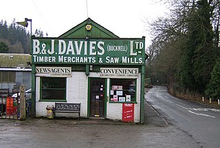
Bucknell is a village and civil parish in south Shropshire, England. The village lies on the River Redlake, within 660 yards (600 m) of the River Teme and close to the border of Wales and Herefordshire. It is about 6 miles (9.7 km) east of Knighton and is set within the Shropshire Hills Area of Outstanding Natural Beauty.
In January 1639 Brilliana Harley wrote that Robert Mathey had found a religious painting concealed under a plank in his stable at Buckton. Her father Edward Conway, 1st Viscount Conway broke it up as idolatrous. [6]
The River Teme rises in Mid Wales, south of Newtown, and flows through Knighton where it crosses the border into England down to Ludlow in Shropshire, then to the north of Tenbury Wells on the Shropshire/Worcestershire border there, on its way to join the River Severn south of Worcester. The whole of the River Teme was designated as an SSSI, by English Nature, in 1996.
Anchor is a remote hamlet in southwest Shropshire, England. The hamlet is the most westerly place in Shropshire.
Clungunford is a village and civil parish in south Shropshire, England, located near the border with Herefordshire.
Walford, Letton and Newton is a civil parish in north Herefordshire, England, close to the border with Shropshire. The population of this civil parish at the 2011 census was 179.
Ludford is a small village and civil parish in south Shropshire, England. The parish is situated adjacent to the market town of Ludlow and was, until 1895, partly in Herefordshire.
Beckjay is a hamlet in the south of the English county of Shropshire.
The A4113 road is a single-carriageway road that runs from Knighton in Powys to Bromfield in Shropshire, United Kingdom, passing through north Herefordshire.
Shelderton is a hamlet in south Shropshire, England. It is located just southeast of the village of Clungunford and is part of that village's civil parish.
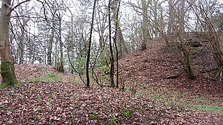
Mainstone is a small village and civil parish in southwest Shropshire, England, near the border with Powys, Wales. The village lies approximately 1 mile northwest of the small village of Cefn Einion. The market town of Bishop's Castle lies some 3 miles to the east, while the small town of Clun is about 5 miles away to the south.
Croft Ambrey is a British Iron Age hill fort in northern Herefordshire, 10 kilometres (6 mi) north of Leominster close to the present day county border with South Shropshire.
Richard's Castle is a village, castle and two civil parishes on the border of the counties of Herefordshire and Shropshire in England. The Herefordshire section of the parish had a population of 250 at the 2011 Census. The Shropshire section of the parish had a population of 424 at the 2011 Census.
Broadward is a dispersed hamlet in south Shropshire, England, situated by the border with Herefordshire. It is in the civil parish of Clungunford, a village approximately 2 miles (3.2 km) to the north.
Marlow is a hamlet in north Herefordshire, England.
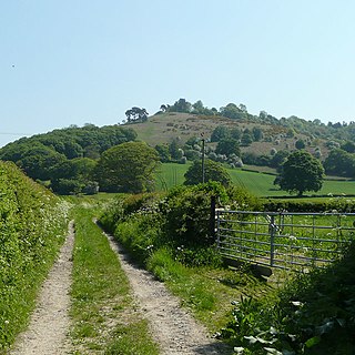
Heath is a dispersed hamlet in north Herefordshire, England.
The Redlake is a minor river in southwest Shropshire, England.
Munslow is a hundred of Shropshire, England. It was formed with the amalgamation of the Anglo-Saxon hundreds of Patton and Culvestan during the reign of Henry I. Hundreds in England had various judicial, fiscal and other local government functions, their importance gradually declining from the end of manorialism to the latter part of the 19th century.
Wikimedia Commons has media related to Buckton and Coxall . |