Mường Chà is a rural district of Điện Biên Province in the Northwest region of Vietnam. As of 2003 the district had a population of 49,242. The district covers an area of 1,826 km². The district capital lies at Mường Chà.
Baba is a village in the administrative district of Gmina Mogilno, within Mogilno County, Kuyavian-Pomeranian Voivodeship, in north-central Poland.

Teptiuków is a village in the administrative district of Gmina Hrubieszów, within Hrubieszów County, Lublin Voivodeship, in eastern Poland, close to the border with Ukraine. It lies approximately 4 kilometres (2 mi) east of Hrubieszów and 107 km (66 mi) south-east of the regional capital Lublin.
Ładzin is a village in the administrative district of Gmina Pajęczno, within Pajęczno County, Łódź Voivodeship, in central Poland. It lies approximately 7 kilometres (4 mi) south-east of Pajęczno and 79 km (49 mi) south of the regional capital Łódź.
Marżynek is a village in the administrative district of Gmina Zapolice, within Zduńska Wola County, Łódź Voivodeship, in central Poland. It lies approximately 5 kilometres (3 mi) north-east of Zapolice, 5 km (3 mi) south-west of Zduńska Wola, and 44 km (27 mi) south-west of the regional capital Łódź.
Kaliszany-Kolonia is a village in the administrative district of Gmina Józefów nad Wisłą, within Opole Lubelskie County, Lublin Voivodeship, in eastern Poland.
Parszów is a village in the administrative district of Gmina Wąchock, within Starachowice County, Świętokrzyskie Voivodeship, in south-central Poland. It lies approximately 6 kilometres (4 mi) west of Wąchock, 10 km (6 mi) west of Starachowice, and 31 km (19 mi) north-east of the regional capital Kielce.
Wola Chynowska is a village in the administrative district of Gmina Chynów, within Grójec County, Masovian Voivodeship, in east-central Poland. It lies approximately 1 kilometre (1 mi) south of Chynów, 16 km (10 mi) east of Grójec, and 36 km (22 mi) south of Warsaw.
Wycinki is a village in the administrative district of Gmina Grodziec, within Konin County, Greater Poland Voivodeship, in west-central Poland. It lies approximately 22 kilometres (14 mi) south-west of Konin and 85 km (53 mi) south-east of the regional capital Poznań.
Moczydła is a village in the administrative district of Gmina Dobra, within Turek County, Greater Poland Voivodeship, in west-central Poland.
Miłocice is a village in Gmina Miastko, Bytów County, Pomeranian Voivodeship, in northern Poland. It lies approximately 26 kilometres (16 mi) south-west of Bytów and 74 km (46 mi) south-west of Gdańsk.
Oksza is a village in the administrative district of Gmina Witnica, within Gorzów County, Lubusz Voivodeship, in western Poland.
Stawno is a settlement in the administrative district of Gmina Złotów, within Złotów County, Greater Poland Voivodeship, in west-central Poland. It lies approximately 4 kilometres (2 mi) north-east of Złotów and 109 km (68 mi) north of the regional capital Poznań.
Smolno Małe is a village in the administrative district of Gmina Kargowa, within Zielona Góra County, Lubusz Voivodeship, in western Poland.
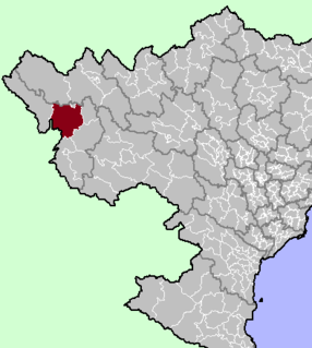
Dzbańce-Osiedle is a village in the administrative district of Gmina Branice, within Głubczyce County, Opole Voivodeship, in south-western Poland, close to the Czech border. It lies approximately 5 kilometres (3 mi) north-east of Branice, 14 km (9 mi) south of Głubczyce, and 66 km (41 mi) south of the regional capital Opole.
Buksewo is a settlement in the administrative district of Gmina Lipnica, within Bytów County, Pomeranian Voivodeship, in northern Poland. It lies approximately 9 kilometres (6 mi) south-west of Lipnica, 25 km (16 mi) south-west of Bytów, and 98 km (61 mi) south-west of the regional capital Gdańsk.
Zerbuń is a village in the administrative district of Gmina Jeziorany, within Olsztyn County, Warmian-Masurian Voivodeship, in northern Poland. It lies approximately 9 kilometres (6 mi) south-east of Jeziorany and 29 km (18 mi) north-east of the regional capital Olsztyn.
Metsaääre is a village in Kehtna Parish, Rapla County in northern-central Estonia.
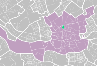
Bergpolder is a neighborhood of Rotterdam, Netherlands.
Estadio Municipal de Anduva is a stadium in Miranda de Ebro, Spain. It has a capacity of 5,759 spectators and opened in 1950. It is the home of CD Mirandés of the Segunda División.


