A distributary, or a distributary channel, is a stream that branches off and flows away from a main stream channel. They are a common feature of river deltas. The phenomenon is known as river bifurcation. The opposite of a distributary is a tributary. Distributaries usually occur as a stream nears a lake or an ocean, but they can occur inland as well, such as on alluvial fans or when a tributary stream bifurcates as it nears its confluence with a larger stream. In some cases, a minor distributary can divert so much water from the main channel that it can become the main route.

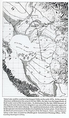
The Central Valley is a flat valley that dominates the geographical center of the U.S. state of California. It is 40 to 60 miles wide and stretches approximately 450 miles (720 km) from north-northwest to south-southeast, inland from and parallel to the Pacific Ocean coast. It covers approximately 18,000 square miles (47,000 km2), about 11% of California's total land area. The valley is bounded by the Sierra Nevada to the east and the Coast Ranges to the west.
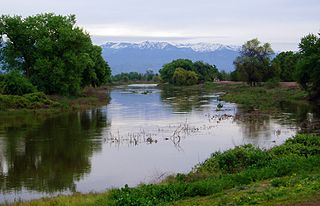
The St. John's River is a distributary of the Kaweah River in the San Joaquin Valley of California in the United States. The river begins at a diversion dam at McKay's Point, about a mile west of Lemon Cove. The distributary flows west along the north side of the city of Visalia, where it joins Elbow Creek, continuing west to Cross Creek.

The Governor Edmund G. Brown California Aqueduct is a system of canals, tunnels, and pipelines that conveys water collected from the Sierra Nevada Mountains and valleys of Northern and Central California to Southern California. Named after California Governor Edmund Gerald "Pat" Brown Sr., the over 400-mile (640 km) aqueduct is the principal feature of the California State Water Project.

The Friant-Kern Canal is a 152 mi (245 km) Central Valley Project aqueduct managed by the United States Bureau of Reclamation in Central California to convey water to augment irrigation capacity in Fresno, Tulare, and Kern counties. Construction began in 1949 and the canal was completed in 1951, at a cost of $60.8 million.
Kern River Slough is a former settlement in Kern County, California.
Kern River Slough was the distributary of the Kern River running south from the vicinity of Bakersfield to Kern Lake near Arvin, in Kern County, California.
Buena Vista was a Yokutsan language of California.
Fresno Slough is a distributary of the Kings River that connects the North Fork Kings River (distributary) to the San Joaquin River in the San Joaquin Valley, in Kings County, California.
Chico Martinez Creek, formerly Arroyo Chico Martinez is a stream with its source located in the Temblor Range in Kern County, California near to the San Luis Obispo County boundary. Its source is located 10.7 miles north of Soda Lake, California in the middle of the Carrizo Plain. The creek runs generally east and northeast to terminate just east of the South Belridge Oil Field. In years of heavy rainfall it may have been a tributary to the Kern River between Buena Vista Lake and Tulare Lake.
Carrier Canal is an irrigation canal in Kern County, California. It originates from a common diversion at Manor Street in Bakersfield, which also supplies the Kern Island Canal and Eastside Canal. The common diversion originates from the Kern River about 1 mile (1.6 km) south of Gordon's Ferry. There are additional diversions from the Kern River at Golden State Highway and Coffee Road. The canal terminates at the Kern River, near Enos Lane west of Bakersfield. For its entire length, it runs roughly parallel to the Kern River.
Buena Vista Canal is an irrigation canal in Kern County, California. It originates from the Carrier Canal at Coffee Road. The canal terminates at Lake Webb and the Kern River.
Connecting Slough, the former slough between Kern Lake and Buena Vista Lake in the southeastern San Joaquin Valley, in Kern County, California.
Lux v. Haggin, 69 Cal. 255; 10 P. 674; (1886), is a historic case in the conflict between riparian and appropriative water rights. Decided by a vote of four to three in the Supreme Court of California, the ruling held that appropriative rights were secondary to riparian rights.

Lake Corcoran is an ancient lake that covered the Central Valley of California.
Buena Vista Pumping Plant is a water pumping plant of the California State Water Project, located 22 miles southwest of Bakersfield, within Kern County, in the San Joaquin Valley, central California.