
Cattaraugus County is a county in Western New York, with one side bordering Pennsylvania. As of the United States 2020 census, the population was 77,042. The county seat is Little Valley. The county was created in 1808 and later organized in 1817. The county is part of the Western New York region of the state.

Erie County is a county along the shore of Lake Erie in western New York State. As of the 2020 census, the population was 954,236. The county seat is Buffalo, which makes up about 28% of the county's population. Both the county and Lake Erie were named for the regional Iroquoian language-speaking Erie tribe of Native Americans, who lived in the area before 1654. They were later pushed out by the more powerful Iroquoian nations tribes. The county is part of the Western New York region of the state.
Silver Creek is a village in the town of Hanover in Chautauqua County, New York, United States. As of the 2020 census, the village had a population of 2,637. Silver Creek is named after a small creek which runs through the village. It is on the shore of Lake Erie.

Gowanda is a village in western New York, United States. It lies partly in Erie County and partly in Cattaraugus County. The population was 2,513 at the 2020 census. The name is derived from a local Seneca language term meaning "almost surrounded by hills" or "a valley among the hills". The Erie County portion of Gowanda is part of the Buffalo–Niagara Falls metropolitan statistical area, while the Cattaraugus County portion is part of the Olean micropolitan statistical area.
Salamanca is a city in Cattaraugus County, New York, United States, inside the Allegany Indian Reservation, one of two governed by the Seneca Nation of New York. The population was 5,929 at the 2020 census. It was named after José de Salamanca, a Spanish nobleman and cabinet minister of the mid-19th century. Salamanca invested in railroads around the globe, including the Atlantic and Great Western Railroad in New York State, Pennsylvania, and Ohio.
The Southern Tier is a geographic subregion of the broader Upstate region of New York State, geographically situated along or very near the state border with Pennsylvania. Definitions of the region vary widely, but generally encompass counties surrounding the Binghamton and Elmira-Corning metropolitan areas. This region is adjacent to the Northern Tier of Pennsylvania, and both these regions together are known as the Twin Tiers.

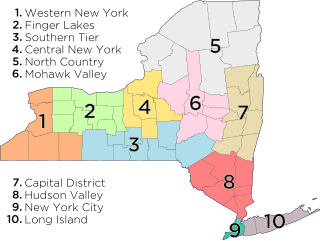
Western New York (WNY) is the westernmost region of the U.S. state of New York. The eastern boundary of the region is not consistently defined by state agencies or those who call themselves "Western New Yorkers". Almost all sources agree WNY includes the cities of Buffalo, Niagara Falls, Jamestown, and the surrounding suburbs, as well as the outlying rural areas of Niagara Frontier, and Chautauqua-Alleghany. Many would also place Rochester and the Genesee Valley in the region, although those legally belong in the Finger Lakes Region and are separate from Western New York Region.
The Erie Railroad was a railroad that operated in the Northeastern United States, originally connecting Pavonia Terminal in Jersey City, New Jersey, with Lake Erie at Dunkirk, New York. The railroad expanded west to Chicago following its 1865 merger with the former Atlantic and Great Western Railroad, also known as the New York, Pennsylvania and Ohio Railroad.

The Delaware, Lackawanna and Western Railroad, also known as the DL&W or Lackawanna Railroad, was a U.S. Class 1 railroad that connected Buffalo, New York, and Hoboken, New Jersey, and by ferry with New York City, a distance of 395 miles (636 km). The railroad was incorporated in Pennsylvania in 1853, and created primarily to provide a means of transport of anthracite coal from the Coal Region in Northeast Pennsylvania to large coal markets in New York City. The railroad gradually expanded both east and west, and eventually linked Buffalo with New York City.

Cattaraugus Creek is a stream, approximately 68 miles (109 km) long, in western New York in the United States. The creek drains a wooded rural portion of western New York southwest of Buffalo into Lake Erie. In its lower course it flows primarily through the Cattaraugus Reservation of the Seneca tribe. William Beauchamp identifies the name Cattaraugus as deriving from the Seneca word Gah-ta-ra-ke-ras, meaning "stinking shore" or "foul-smelling river bank." This in turn is likely a loanword from an extinct Attiwandiron, Erie, Wenro, or Wendat (Huron) language, combining the verb root -i'tar-, referring to clay or mud, and -akera(n)-, describing a bad or strong odor: hence, tke'tarakeras, place of strong-smelling mud or clay. This name is a result of the natural gas that oozes from the river mud.

The Finger Lakes Railway is a Class III railroad in the Finger Lakes region of New York. The company began operations on July 23, 1995, and operates in Onondaga, Cayuga, Seneca, Ontario, Schuyler and Yates counties. The FGLK operates 18 diesel locomotives on 167 miles (269 km) of ex-Conrail trackage, formerly owned by the New York Central Railroad, the Pennsylvania Railroad and the Lehigh Valley Railroad. Between 2001 and 2013, the railroad operated a heritage railroad known as the Finger Lakes Scenic Railway which offered passenger train excursions.
Waterboro is a hamlet in Chautauqua County, New York, United States at an elevation of 1293 ft above sea level. Located in the northeast corner of the Town of Poland, it is now a closed railroad depot.

The Buffalo Southern Railroad is a class III railroad operating in western New York.

The Buffalo and Jamestown Railroad was a railroad that ran between the towns of Jamestown, NY and Buffalo, NY. It was a predecessor of the Erie Railroad.
The Erie and New York City Railroad was a railroad that operated in New York state.

The Western New York and Pennsylvania Railroad is a short-line railroad that operates freight trains in Western New York and Northwest Pennsylvania. The company is controlled by the Livonia, Avon and Lakeville Railroad, with which it does not connect. It started operations in 2001 on the Southern Tier Extension, a former Erie Railroad line between Hornell, New York and Corry, Pennsylvania, owned by the public Chautauqua, Cattaraugus, Allegany and Steuben Southern Tier Extension Railroad Authority (STERA).

The Southtowns is a region of Western New York, United States, that lies within the snowbelt or ski country. It includes the southern suburbs of Buffalo, New York. This is the common name for the southern part of Erie County, New York.

The New York & Lake Erie is a class III railroad operating in Western New York. The NYLE was formed in 1978 to operate a portion of former Erie trackage that Conrail no longer wanted. Today, the railroad operates between Gowanda to Cherry Creek, New York. The main branch of the trackage connects with multiple railroads in Buffalo, New York and once connected with the now-WNYP owned (NS-leased) Southern Tier Line in Waterboro. However, that portion of the line and the junction at Waterboro were decommissioned several years ago. The NYLE also operated a branch Line between Dayton and Salamanca, also connecting with the Southern Tier Line there, until 1990; the portion south of Cattaraugus was torn out and eventually replaced with the Pat McGee Trail in the early 2000s, while the portion north of Cattaraugus was damaged by floods and landslides in the 2010s and is also no longer operational.


