Related Research Articles

Salisbury is a cathedral city in Wiltshire, England, with a population of 40,302, at the confluence of the rivers Avon, Nadder and Bourne. The city is approximately 20 miles from Southampton and 30 miles from Bath.

Old Sarum, in Wiltshire, South West England, is the now ruined and deserted site of the earliest settlement of Salisbury. Situated on a hill about two miles north of modern Salisbury near the A345 road, the settlement appears in some of the earliest records in the country. It is an English Heritage property and is open to the public.

Mere is a small town and civil parish in Wiltshire, England. It lies at the extreme southwestern tip of Salisbury Plain, close to the borders of Somerset and Dorset. The parish includes the hamlets of Barrow Street, Burton, Charnage, Limpers Hill, Rook Street and Southbrook.

Salisbury Plain is a chalk plateau in the south western part of central southern England covering 300 square miles (780 km2). It is part of a system of chalk downlands throughout eastern and southern England formed by the rocks of the Chalk Group and largely lies within the county of Wiltshire, but stretches into Hampshire.

Gowanus is a neighborhood in the northwestern portion of the New York City borough of Brooklyn, within the area once known as South Brooklyn. The neighborhood is part of Brooklyn Community District 6. Gowanus is bounded by Wyckoff Street on the north, Fourth Avenue on the east, the Gowanus Expressway to the south, and Bond Street to the west.

The Diocese of Salisbury is a Church of England diocese in the south of England, within the ecclesiastical Province of Canterbury. The diocese covers most of Dorset, and most of Wiltshire. The diocese is led by Stephen Lake, Bishop of Salisbury and the diocesan synod. The bishop's seat is at Salisbury Cathedral.

West Lavington is a village and civil parish in Wiltshire, England, on the north edge of Salisbury Plain, on the A360 road between Devizes and Salisbury, about 5 miles (8 km) south of Devizes. The parish includes the hamlet of Littleton Panell.

Stratton St Margaret is a civil parish in the Borough of Swindon, Wiltshire, England. The parish covers north-eastern suburbs of Swindon including Stratton St Margaret itself along with Upper Stratton, Lower Stratton and Kingsdown. Since May 2015, Nythe has been legally separated from Stratton St. Margaret and now forms its own parish council.

Tisbury is a large village and civil parish approximately 13 miles (21 km) west of Salisbury in the English county of Wiltshire. With a population at the 2011 census of 2,253 it is a centre for communities around the upper River Nadder and Vale of Wardour. The parish includes the hamlets of Upper Chicksgrove and Wardour.
Harnham is a suburb of the city of Salisbury in Wiltshire, England, centred about 0.6 miles (1 km) south of Salisbury Cathedral and across the River Avon. Harnham is split into the areas of West Harnham and East Harnham.

Stockton is a small village and civil parish in the Wylye Valley in Wiltshire, England, about 8 miles (13 km) southeast of Warminster. The parish includes the hamlet of Bapton.

Chilmark is a Wiltshire village and civil parish of some 150 houses straddling the B3089 road, 11 miles (18 km) west of Salisbury, England. The parish includes the hamlets of Mooray and Portash, both close to the south of Chilmark village; and the dispersed hamlet of Ridge, to the southwest.
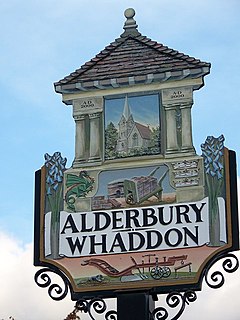
Alderbury is a village and civil parish in Wiltshire, England, situated 3 miles (5 km) southeast of Salisbury.
Moulsham is a suburb of Chelmsford, Essex, England. It is located to the south of the city centre and has two distinct areas: Old Moulsham and Moulsham Lodge.

The buildings known as Whitefriars are the surviving fragments of a Carmelite friary founded in 1342 in Coventry, England. All that remains are the eastern cloister walk, a postern gateway in Much Park Street and the foundations of the friary church. It was initially home to a friary until the Dissolution of the Monasteries. During the 16th century it was owned by John Hales and served as King Henry VIII School, Coventry, before the school moved to St John's Hospital, Coventry. It was home to a workhouse during the 19th century. The buildings are currently used by Herbert Art Gallery and Museum, Coventry.
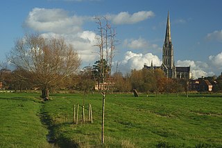
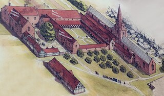
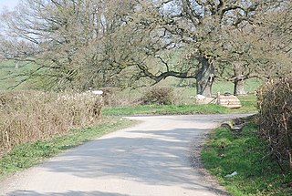
Salisbury Grey Friary was a friary in Wiltshire, England between the 1230s and 1538.
The Franciscan Friary was once a large estate located on the west side of Lichfield city centre in Staffordshire. The estate was built and inhabited by the Franciscan Friars from 1237. At one time the estate consisted of a large church, a cloister, dormitory lodge and a refectory building as well as many other domestic dwellings.

Laverstock is a village and civil parish on the north-east and east outskirts of Salisbury in the ceremonial county of Wiltshire, England. The parish is shaped like a figure 7 and incorporates Ford hamlet, the eastern half of the former manor of Milford, the area near the ancient settlement of Old Sarum, and part of the Hampton Park district on the edge of Salisbury.
Clarendon Park is a Grade I listed building, estate and civil parish near Salisbury in Wiltshire, England. At the 2011 census the population of the parish was 246.
West Tisbury is a civil parish in southwest Wiltshire, England. The parish takes in the southwestern quarter of the village of Tisbury and extends about 3.8 miles (6.1 km) westward; Tisbury is about 13 miles (21 km) west of Salisbury.
References
- 1 2 Crittall, Elizabeth, ed. (1962). "Victoria County History: Wiltshire: Vol 6 pp79-81 - Salisbury: St Martin's parish". British History Online. University of London. Retrieved 26 February 2018.
- ↑ "The Friary". Salisbury Vision. Archived from the original on 28 May 2014. Retrieved 3 June 2013.