Bujaru

Last updated
Bujaru
Municipality
Para Municip Bujaru.svg
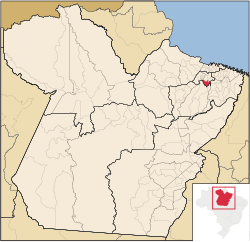
Bujaru in Pará State
CountryFlag of Brazil.svg  Brazil
Region Northern
State Pará
Mesoregion Metropolitana de Belém
Time zone UTC -3

Bujaru is a municipality in the state of Pará in the Northern region of Brazil. [1] [2] [3] [4]

Municipalities of Brazil administrative division of the states in Brazil

The municipalities of Brazil are administrative divisions of the Brazilian states. At present, Brazil has 5,570 municipalities, making the average municipality population 34,361. The average state in Brazil has 214 municipalities. Roraima is the least subdivided state, with 15 municipalities, while Minas Gerais is the most subdivided state, with 853.

States of Brazil administrative entity of Brazil

The Federative Republic of Brazil is a union of 27 federated units : 26 states and one federal district. The states are generally based on historical, conventional borders which have developed over time. The Federal District cannot be divided into municipalities, according to the Brazilian Constitution, the Federal District assumes the same constitutional and legal powers, attributions and obligations of the states and municipalities, instead, it is divided by administrative regions.

Pará State of Brazil

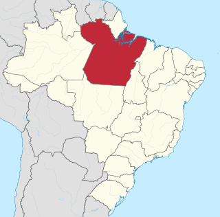
Pará is a state in northern Brazil traversed by the lower Amazon River. It borders the Brazilian states of Amapá, Maranhão, Tocantins, Mato Grosso, Amazonas and Roraima. To the northwest it borders Guyana and Suriname; to the northeast it borders the Atlantic Ocean. The capital and largest city is Belém, at the mouth of the Amazon at the Atlantic Ocean and the 11th most populous city in the country.

See also

Related Research Articles

Jitaúna is a municipality in the state of Bahia in the North-East region of Brazil.

São Miguel das Matas is a municipality in the state of Bahia in the North-East region of Brazil.

Ubatã Municipality in Nordeste, Brazil

Ubatã is a municipality in the state of Bahia in the North-East region of Brazil.

Rio Negrinho is a municipality in the state of Santa Catarina in the South region of Brazil.

Iomerê is a municipality in the state of Santa Catarina in the South region of Brazil.

Treviso, Santa Catarina is a municipality in the state of Santa Catarina in the South region of Brazil.

Cana Verde is a municipality in the state of Minas Gerais in the Southeast region of Brazil.

Mar de Espanha is a municipality in the state of Minas Gerais in the Southeast region of Brazil.

Alto Paraguai is a municipality in the state of Mato Grosso in the Mid-West of Brazil.

Moreira Sales is a municipality in the state of Paraná in the Southern Region of Brazil.

Goioxim is a municipality in the state of Paraná in the Southern Region of Brazil.

Alto Piquiri is a municipality in the state of Paraná in the Southern Region of Brazil.

Primeiro de Maio, Paraná is a municipality in the state of Paraná in the Southern Region of Brazil.

Guapirama is a municipality in the state of Paraná in the Southern Region of Brazil.

Cruz Machado is a municipality in the state of Paraná in the Southern Region of Brazil.

Pranchita is a municipality in the state of Paraná in the Southern Region of Brazil.

Joaquim Pires Municipality in Nordeste, Brazil

Joaquim Pires is a municipality in the state of Piauí in the Northeast region of Brazil.

Talismã is a municipality in the state of Tocantins in the Northern region of Brazil.

Fortaleza do Tabocão is a municipality in the state of Tocantins in the Northern region of Brazil.

Pedro Afonso is a municipality in the state of Tocantins in the Northern region of Brazil.

References

  1. "Divisão Territorial do Brasil" (in Portuguese). Divisão Territorial do Brasil e Limites Territoriais, Instituto Brasileiro de Geografia e Estatística (IBGE). July 1, 2008. Retrieved December 17, 2009.
  2. "Estimativas da população para 1º de julho de 2009" (PDF) (in Portuguese). Estimativas de População, Instituto Brasileiro de Geografia e Estatística (IBGE). August 14, 2009. Retrieved December 17, 2009.
  3. "Ranking decrescente do IDH-M dos municípios do Brasil" (in Portuguese). Atlas do Desenvolvimento Humano, Programa das Nações Unidas para o Desenvolvimento (PNUD). 2000. Archived from the original on October 3, 2009. Retrieved December 17, 2009.
  4. "Produto Interno Bruto dos Municípios 2002-2005" (PDF) (in Portuguese). Instituto Brasileiro de Geografia e Estatística (IBGE). December 19, 2007. Archived from the original (PDF) on October 2, 2008. Retrieved December 17, 2009.

Coordinates: 1°31′S48°01′W / 1.517°S 48.017°W / -1.517; -48.017

Geographic coordinate system Coordinate system

A geographic coordinate system is a coordinate system that enables every location on Earth to be specified by a set of numbers, letters or symbols. The coordinates are often chosen such that one of the numbers represents a vertical position and two or three of the numbers represent a horizontal position; alternatively, a geographic position may be expressed in a combined three-dimensional Cartesian vector. A common choice of coordinates is latitude, longitude and elevation. To specify a location on a plane requires a map projection.