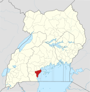
Wakiso District is a district in the Central Region of Uganda that partly encircles Kampala, Uganda's capital city. The town of Wakiso is the site of the district headquarters. Kira, the country's second largest city and suburb of Kampala, is in the district.

Sembabule is a town in Sembabule District in the Central Region of Uganda. The town is the main municipal, administrative, and commercial center of the district and the site of the district headquarters.
Mbarara Regional Referral Hospital, commonly known as Mbarara Hospital, is a hospital in Mbarara in the Western Region of Uganda. It is the referral hospital for the region and specifically for the districts of Mbarara, Bushenyi, Ntungamo, Kiruhura, Ibanda, and Isingiro. The hospital serves as the teaching hospital for the Mbarara University of Science and Technology.
Nateete is a location in the city of Kampala, Uganda's capital.
Kalisizo is a town in the southern part of the Central Region of Uganda. Although it is the leading commercial center in Kyotera District, the administrative headquarters of the district are in Kasaali.
Lukaya is a town in the Kalungu District of the Central Region of Uganda.
Nsangi is a town in the Central Region of Uganda. It is one of the urban centers in Wakiso District.
Kakuuto is a town in southwestern Central Uganda.
Busega is a neighborhood within Kampala, the capital and largest city of Uganda.
Nkozi is a town in central Uganda. It is one of the urban centers in Mpigi District.
Bukomansimbi is a town in the Central Region of Uganda. It is the chief municipal, administrative, and commercial center of Bukomansimbi District and the site of the district headquarters.

Kalungu is a town in the Central Region of Uganda. It is the chief municipal, administrative, and commercial center in Kalungu District.
Lwengo is a town in Central Uganda. It is the chief municipal, administrative and commercial center of Lwengo District. It was known as Mbiriizi, prior to 1 July 2010.
Mutundwe is a neighborhood in the town of Ssabagabo in Uganda. The name also refers to Mutundwe Hill, where the neighborhood is located.
Kyengera is a town in the Central Region of Uganda. It is one of the urban centers in Wakiso District.
Abayita Ababiri, sometimes spelled Abaita Ababiri, is a neighborhood in Uganda.

The Masaka–Bukakata Road is a road in the Central Region of Uganda, connecting the city of Masaka to the lakeside town of Bukakata in Masaka District. As of September 2020, the road surface was gravel, which washed away when it rained, stranding motorists, traders and their merchandise.
Kisubi is a neighborhood in the Central Region of Uganda.
The Isingiro–Ntantamuki–Rakai Road is a road in the Central and Western Regions of Uganda, connecting the towns of Isingiro, in Isingiro District, Western Region and Rakai in Rakai District, Central Region.
The Nakawuka–Kasanje–Mpigi Road, is a road in the Central Region of Uganda, connecting the towns of Nakawuka and Kasanje in Wakiso District to the city of Mpigi, the district capital of Mpigi District. When completed, the road is expected to ease travel between the city of Entebbe and Mpigi, Masaka and communities in the Western Region of Uganda. The road bypasses the road traffic congestion around Kampala, the national capital.


