The Democratic Republic of the Congo (DRC) is the largest country of sub-Saharan Africa, occupying some 2,344,858 square kilometres (905,355 sq mi). Most of the country lies within the vast hollow of the Congo River basin. The vast, low-lying central area is a plateau-shaped basin sloping toward the west, covered by tropical rainforest and criss-crossed by rivers. The forest center is surrounded by mountainous terraces in the west, plateaus merging into savannas in the south and southwest. Dense grasslands extend beyond the Congo River in the north. High mountains of the Ruwenzori Range are found on the eastern borders with Rwanda and Uganda.

The Republic of the Congo is located in the western part of central Africa. Situated on the Equator, it is bordered by the Angolan exclave of Cabinda to the south (231 km), the Democratic Republic of the Congo to the north and east (1,229 km), the Central African Republic (487 km) and Cameroon (494 km) to the north and Gabon to the west (2,567 km). Congo has a 169 km long Atlantic coast with several important ports. The Republic of the Congo covers an area of 342,000 km², of which 341,500 km² is land while 500 km² is water. Congo claims 200 nautical miles (370 km) of territorial sea.
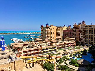
El Alamein is a town in the northern Matrouh Governorate of Egypt. Located on the Mediterranean Sea, it lies 106 kilometres (66 mi) west of Alexandria and 300 kilometres (186 mi) northwest of Cairo. As of 2007, it had a population of 7,397 inhabitants.

Goma is the capital of North Kivu province in the eastern Democratic Republic of the Congo. It is located on the northern shore of Lake Kivu, next to the Rwandan city of Gisenyi. The lake and the two cities are in the Albertine Rift, the western branch of the East African Rift system. Goma lies only 13–18 km (8.1–11.2 mi) south of the active Nyiragongo Volcano. The recent history of Goma has been dominated by the volcano and the Rwandan genocide of 1994, which in turn fueled the First and Second Congo Wars. The aftermath of these events was still having effects on the city and its surroundings in 2010. The city was captured by rebels of the March 23 Movement during the M23 rebellion in late 2012, but it has since been retaken by government forces.

Boma is a port town on the Congo River, some 100 kilometres (62 mi) upstream from the Atlantic Ocean, in the Kongo Central Province of the Democratic Republic of the Congo (DRC), adjacent to the border with Angola. It had an estimated population of 162,521 in 2012.
Moanda or Muanda is a town and territory lying on the Atlantic Ocean coast of the Democratic Republic of the Congo at the mouth of the Congo River. It is situated in Kongo Central Province, and has a population of 90,812 as of 2012. The town has an airport and is known for its beaches, and has a few limited tourist facilities, but tourism is incidental to the main economic activities of the town.
Boende is a city and capital of Tshuapa Province, lying on the Tshuapa River, in the Democratic Republic of Congo. It is a river port with riverboats sailing to Kinshasa via Mbandaka and is also home to an airport. As of 2009, it had an estimated population of 36,158. The national language used locally is Lingala.
Mendi, Papua New Guinea, is the provincial capital of the Southern Highlands Province. The Lai River flows by the town. It is served by Mendi Airport. The town falls under Mendi Urban LLG.
Bimbo is located 25.5 kilometres (15.8 mi) by road southwest of the centre of the capital, Bangui. The country's second-largest city, Bimbo had a population of 124,176 as of the 2003 census and a calculated 2013 population of 267,859. Bimbo used to be the capital city of Ombella-M'Poko until December 2020. Since December 2020, Bimbo has been part of Bangui Prefecture.
Qaha is a city in northeastern Egypt, located 25 km north of Cairo. It is located in the rich farmland of the southern part of the Nile Delta, and is well-irrigated by canals leading off the Delta Barrage.

Khaudum National Park is an isolated Nature Reserve situated in the Kalahari Desert to the west of the Caprivi Strip in the northeast of Namibia. It is a very remote and inaccessible reserve, but is home to some magnificent animals, such as the lion and hyena. The park also has a campsite for visitors.

Papanasam is a panchayat town in Thanjavur district in the Indian state of Tamil Nadu. It is located 25 kilometres (16 mi) from Thanjavur and 15 kilometres (9.3 mi) from Kumbakonam. The name literally translates to "Destruction of Sins" in the Tamil language. It is the suburban region of Kumbakonam.
Galafi, also known as Gâlâfi, is a village in Djibouti. Galafi is the official border crossing from Djibouti into Ethiopia. Situated on the border with Ethiopia, it is in the north west of Dikhil. It lies on the National Highway 1. It is located some 218 km (135 mi) west of the national capital, Djibouti City. Nearby towns and villages include Yoboki, Dikhil, Semera, Bure and Elidar.
Bike is a town in central Ethiopia of the Somali Region in the Sitti Zone. It is located 72 km west of Shinile. The town is located on the main railway between Djibouti City and Addis Ababa.
Kyazanga is a town council in the Lwengo District of the Central Region of Uganda.
Cotagaita is a small town in Bolivia. In 2009 it had an estimated population of 1904.
Watsa is a community in the Haut-Uele Province of the Democratic Republic of the Congo, administrative center of the Watsa Territory. It is served by Watsa Airport, a grass airstrip 4 kilometres (2.5 mi) south of the town.

Haut-Lomami is one of the 21 new provinces of the Democratic Republic of the Congo created in the 2015 repartitioning. Haut-Lomami, Haut-Katanga, Lualaba, and Tanganyika provinces are the result of the dismemberment of the former Katanga province. Haut-Lomami was formed from the Haut-Lomami district whose town of Kamina was elevated to capital city of the new province.
Bukama is a territory in the Haut-Lomami province of the Democratic Republic of the Congo. The territory contains town of Bukama, as well as the eastern half of Upemba National Park.
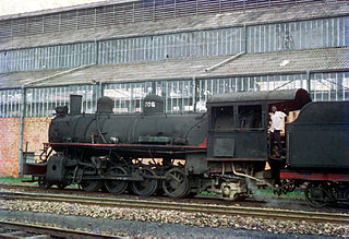
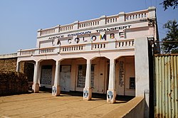
The Compagnie du chemin de fer du bas-Congo au Katanga (BCK) was a railway operator in the Congo Free State, Belgian Congo and later in the Democratic Republic of the Congo and Zaire. Most of the lines were in the southern Katanga Province, with links to the Kasai River for transport of mineral exports down to Kinshasa and onward to the port of Matadi, and a link to the Angolan railway network for transport to Lobito on the Atlantic.