
Choa Chu Kang, alternatively spelled Chua Chu Kang and often abbreviated as CCK, is a planning area and residential town located at the north-westernmost point of the West Region of Singapore. The town shares borders with Sungei Kadut to the north, Tengah to the southwest, Bukit Batok to the southeast, Bukit Panjang to the east and the Western Water Catchment to the west. Choa Chu Kang New Town is separated into two portions by the Kranji Expressway.

Bukit Panjang is a planning area and residential town located in the West Region of Singapore. A portion of this town is situated on a low-lying elongated hill. The planning area is bounded by Bukit Batok to the west, Choa Chu Kang to the northwest, Sungei Kadut to the north, the Central Water Catchment to the east and Bukit Timah to the south. Bukit Panjang New Town is located at the northern portion of the planning area. Bukit Panjang has an average elevation of 36m/118 ft.

The Bukit Timah Expressway (BKE) is a highway in Singapore that starts at the Pan Island Expressway in Bukit Timah and travels north to the Woodlands Checkpoint and the Johor–Singapore Causeway in Woodlands.

Rail transport in Singapore mainly consists of a passenger urban rail transit system spanning the entire city-state: a rapid transit system collectively known as the Mass Rapid Transit (MRT) system operated by the two biggest public transport operators SMRT Trains and SBS Transit, as well as several Light Rail Transit (LRT) rubber-tyred automated guideway transit lines also operated by both companies. In addition, local specialised light rail lines are in operation in places such as the Singapore Changi Airport and Sentosa.

Tanjong Pagar railway station, also called Singapore railway station or Keppel Road railway station, is a former railway station located at 30 Keppel Road in Singapore. The station was the southern terminus of the network operated by Keretapi Tanah Melayu (KTM), the main railway operator in Malaysia, until 30 June 2011 when the station ceased operations with relocation of the KTM station to Woodlands Train Checkpoint. The land on which the station and the KTM railway tracks stood was originally owned by KTM and over which Malaysia had partial sovereignty. This arrangement lasted until 30 June 2011, when rail service to Tanjong Pagar was ended and the land reverted to Singapore.

The Battle of Kranji was the second stage of the Empire of Japan's plan for the invasion of Singapore during the Second World War. On 9 February 1942 the Imperial Japanese Army assaulted the north-western front of Singapore, capital of the Straits Settlements.

Bukit Panjang MRT/LRT station is a Mass Rapid Transit (MRT) and Light Rail Transit (LRT) interchange station on the Downtown line (DTL) and the Bukit Panjang LRT line (BPLRT) in Singapore. Located in the namesake estate of Bukit Panjang, the station is at the junction of Upper Bukit Timah Road and Petir Road. The station serves the commercial buildings of Bukit Panjang Plaza, Hillion Mall and Junction 10. It forms a part of the Bukit Panjang Integrated Transport Hub (BPITH), which also contains a bus interchange.

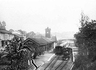
Bukit Timah railway station was a former railway station and crossing loop in Bukit Timah, Singapore.
Tank Road railway station was a railway station which served as a terminus on the Singapore-Kranji Railway from 1903 to 1932.
Newton railway station was a railway station on the Singapore-Kranji Railway, serving Newton from 1903 to 1932.
Cluny Road railway station was a railway station on the Singapore-Kranji Railway from 1903 to 1932.
Borneo Wharf railway station was a railway station which served Borneo Wharf on the Singapore-Kranji Railway from 1907 to 1932.
Pasir Panjang railway station, also known as Alexandra Road railway station or Passir Panjang railway station, was a railway station which served as the terminus of the Singapore-Kranji Railway from 1907 to 1932.
People's Park railway station was a railway station which served the People's Park area on the Singapore-Kranji Railway from somewhere between 1907 and 1909 to somewhere between 1929 and 1932.
Holland Road railway station was a railway station on the Singapore-Kranji Railway from 1903 to 1932.
Kranji railway station was a railway station on the Singapore-Johore Railway which served Kranji for a period of time in the 1900s.
Woodlands railway station was a railway station on the Singapore–Johore Railway which allowed passengers to access ferries bound for Johor from 1903 to 1923.
Tanglin railway station, also known as Tanglin Halt, was a railway station on the Singapore-Johore Railway which served Tanglin, as well as Pasir Panjang, from 1932 to 1983.
Alexandra Halt railway station, or simply Alexandra Halt, was a railway station on the Singapore-Johore Railway which served the surrounding neighbourhoods, and as a halt for trains travelling along the railway, from 3 May 1932 to sometime before 1943.
The Bukit Timah Truss Bridge is a former railway bridge going over Bukit Timah Road and Dunearn Road in Bukit Timah, Singapore.