Related Research Articles
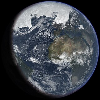
An ice age is a long period of reduction in the temperature of Earth's surface and atmosphere, resulting in the presence or expansion of continental and polar ice sheets and alpine glaciers. Earth's climate alternates between ice ages and greenhouse periods, during which there are no glaciers on the planet. Earth is currently in the Quaternary glaciation. Individual pulses of cold climate within an ice age are termed glacial periods, and intermittent warm periods within an ice age are called interglacials or interstadials.

The Wisconsin Glacial Episode, also called the Wisconsin glaciation, was the most recent glacial period of the North American ice sheet complex. This advance included the Cordilleran Ice Sheet, which nucleated in the northern North American Cordillera; the Innuitian ice sheet, which extended across the Canadian Arctic Archipelago; the Greenland ice sheet; and the massive Laurentide Ice Sheet, which covered the high latitudes of central and eastern North America. This advance was synchronous with global glaciation during the last glacial period, including the North American alpine glacier advance, known as the Pinedale glaciation. The Wisconsin glaciation extended from approximately 75,000 to 11,000 years ago, between the Sangamonian Stage and the current interglacial, the Holocene. The maximum ice extent occurred approximately 25,000–21,000 years ago during the last glacial maximum, also known as the Late Wisconsin in North America.

The Last Glacial Period (LGP), also known colloquially as the last ice age or simply ice age, occurred from the end of the Eemian to the end of the Younger Dryas, encompassing the period c. 115,000 – c. 11,700 years ago. The LGP is part of a larger sequence of glacial and interglacial periods known as the Quaternary glaciation which started around 2,588,000 years ago and is ongoing. The definition of the Quaternary as beginning 2.58 million years ago (Mya) is based on the formation of the Arctic ice cap. The Antarctic ice sheet began to form earlier, at about 34 Mya, in the mid-Cenozoic. The term Late Cenozoic Ice Age is used to include this early phase.

The geology of the Grand Teton area consists of some of the oldest rocks and one of the youngest mountain ranges in North America. The Teton Range, partly located in Grand Teton National Park, started to grow some 9 million years ago. An older feature, Jackson Hole, is a basin that sits aside the range.

There have been five or six major ice ages in the history of Earth over the past 3 billion years. The Late Cenozoic Ice Age began 34 million years ago, its latest phase being the Quaternary glaciation, in progress since 2.58 million years ago.

The Würm glaciation or Würm stage, usually referred to in the literature as the Würm, was the last glacial period in the Alpine region. It is the youngest of the major glaciations of the region that extended beyond the Alps themselves. Like most of the other ice ages of the Pleistocene epoch, it is named after a river, in this case the Würm in Bavaria, a tributary of the Amper. The Würm ice age can be dated to about 115,000 to 11,700 years ago, but sources differ about the dates, depending on whether the long transition phases between the glacials and interglacials are allocated to one or other of those periods. The average annual temperatures during the Würm ice age in the Alpine Foreland were below −3 °C. That has been determined from changes in the vegetation, as well as differences in the facies.

The Last Glacial Maximum (LGM), also referred to as the Late Glacial Maximum, was the most recent time during the Last Glacial Period that ice sheets were at their greatest extent. Ice sheets covered much of Northern North America, Northern Europe, and Asia and profoundly affected Earth's climate by causing drought, desertification, and a large drop in sea levels. According to Clark et al., growth of ice sheets commenced 33,000 years ago and maximum coverage was between 26,500 years and 19–20,000 years ago, when deglaciation commenced in the Northern Hemisphere, causing an abrupt rise in sea level. Decline of the West Antarctica ice sheet occurred between 14,000 and 15,000 years ago, consistent with evidence for another abrupt rise in the sea level about 14,500 years ago.
The Illinoian Stage is the name used by Quaternary geologists in North America to designate the period c.191,000 to c.130,000 years ago, during the middle Pleistocene, when sediments comprising the Illinoian Glacial Lobe were deposited. It precedes the Sangamonian Stage and follows the Pre-Illinoian Stage in North America. The Illinoian Stage is defined as the period of geologic time during which the glacial tills and outwash, which comprise the bulk of the Glasford Formation, accumulated to create the Illinoian Glacial Lobe. It occurs at about the same time as the penultimate glacial period.
The Yarmouthian stage and the Yarmouth Interglacial were part of a now obsolete geologic timescale of the early Quaternary of North America.
The Quaternary glaciation, also known as the Pleistocene glaciation, is an alternating series of glacial and interglacial periods during the Quaternary period that began 2.58 Ma and is ongoing. Although geologists describe the entire time period up to the present as an "ice age", in popular culture the term "ice age" is usually associated with just the most recent glacial period during the Pleistocene or the Pleistocene epoch in general. Since planet Earth still has ice sheets, geologists consider the Quaternary glaciation to be ongoing, with the Earth now experiencing an interglacial period.

U-shaped valleys, also called trough valleys or glacial troughs, are formed by the process of glaciation. They are characteristic of mountain glaciation in particular. They have a characteristic U shape in cross-section, with steep, straight sides and a flat or rounded bottom. Glaciated valleys are formed when a glacier travels across and down a slope, carving the valley by the action of scouring. When the ice recedes or thaws, the valley remains, often littered with small boulders that were transported within the ice, called glacial till or glacial erratic.

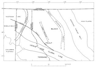
The geology of the Rocky Mountains is that of a discontinuous series of mountain ranges with distinct geological origins. Collectively these make up the Rocky Mountains, a mountain system that stretches from Northern British Columbia through central New Mexico and which is part of the great mountain system known as the North American Cordillera.

The glacial history of Minnesota is most defined since the onset of the last glacial period, which ended some 10,000 years ago. Within the last million years, most of the Midwestern United States and much of Canada were covered at one time or another with an ice sheet. This continental glacier had a profound effect on the surface features of the area over which it moved. Vast quantities of rock and soil were scraped from the glacial centers to its margins by slowly moving ice and redeposited as drift or till. Much of this drift was dumped into old preglacial river valleys, while some of it was heaped into belts of hills at the margin of the glacier. The chief result of glaciation has been the modification of the preglacial topography by the deposition of drift over the countryside. However, continental glaciers possess great power of erosion and may actually modify the preglacial land surface by scouring and abrading rather than by the deposition of the drift.
The Pre-Illinoian Stage is used by Quaternary geologists for the early and middle Pleistocene glacial and interglacial periods of geologic time in North America from ~2.5–0.2 Ma.
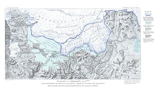
Lake Great Falls was a prehistoric proglacial lake which existed in what is now central Montana in the United States between 15,000 BCE and 11,000 BCE. Centered on the modern city of Great Falls, Montana, Glacial Lake Great Falls extended as far north as Cut Bank, Montana, and as far south as Holter Lake. At present-day Great Falls, the Glacial Lake Great Falls reached a depth of 600 feet.

The Shonkin Sag is a prehistoric fluvioglacial landform located along the northern edge of the Highwood Mountains in the state of Montana in the United States. The Sag is a river channel formed by the Missouri River and glacial meltwater pouring from Glacial Lake Great Falls. It is one of the most famous prehistoric meltwater channels in the world.
The Purcell Trench, also known as the Kootenay River Valley is a large valley on the western side of the northern part of North America's Rocky Mountains. The trench extends approximately 179 miles (288 km) from Lake Pend Oreille, Idaho, down the Kootenay River (north) to Kootenay Lake, up the north arm to Duncan Lake. It joins the Rocky Mountain Trench another 50 miles (80 km) northward at the south tip of Kinbasket Lake, in British Columbia. The trench bottom is 1 to 7 miles wide and is 1,750 to 2,100 feet above sea level. The trench is nearly a straight north or south line. Some of its topography has been carved into U-shaped glacial valleys, it is primarily a product of geologic faulting. The trench splits the Columbia Mountains between the Purcell Mountains on the east and the Selkirk Mountains on the west.

Lake Jordan was a glacial lake formed during the late Pleistocene along the Jordan River. After the Laurentide Ice Sheet retreated, water melting off the glacier accumulated between the Rocky Mountains and the ice sheet. The lake drained along the front of the ice sheet, eastward towards the Yellowstone River and Glacial Lake Glendive.
Lake Circle was a glacial lake that formed during the late Pleistocene epoch along the Redwater River in eastern Montana. After the Laurentide Ice Sheet retreated, glacial ice melt accumulated in the basin surrounded by the ridges of the preglacial valley and the retreating glacier. Southwest of Nickwall are the remnants of a broad abandoned valley with long side slopes. The valley runs north from Redwater Creek to the Missouri River. The bottom is poorly drained and about 1 mile (1.6 km) in width. It lies 2,015 to 2,020 feet above the sea level and 40 to 50 feet above the Missouri River bottomland. The upland slopes are extensive, clear and flat. The valleys surrounding it are dissected with V-shaped coulees. The difference between the Redwater valley and those around it reflect stream erosion vs. lake sedimentation. The drift in the valleys, appears to be as left by the glacier in the previously created valleys. Using the dating of lake deposits near Great Falls, Montana, the Havre lobe of the Laurentide Ice Sheet dammed the ancestral Missouri River during the late Wisconsin Glacial Period.
Lake Chouteau was a glacial lake formed during the late Pleistocene along the Teton River. After the Laurentide Ice Sheet retreated, water melting off the glacier accumulated between the Rocky Mountains and the ice sheet. The lake drained along the front of the ice sheet, eastward towards the Judith River and the Missouri River.
References
- ↑ Fullerton, David S.; Colton, Roger B.; and Bush, Charles A. "Limits of Mountain and Continental Glaciations in Northern Montana and North-Western North Dakota, U.S.A." In Quaternary Glaciations: Extent and Chronology. Part II: North America. Jim Rose, ed. San Diego, Calif.: Elsevier, 2004.
- 1 2 3 4 5 Pierce, Kenneth L. "Pleistocene Glaciations of the Rocky Mountains." Archived 2010-05-30 at the Wayback Machine Development in Quaternary Science. 1 (2003).
- ↑ Kelsey, Joe. Climbing and Hiking in the Wind River Mountains. Evergreen, Colo.: Chockstone Press, 1994; Balckwelder, Eliot. "Post-Cretaceous History of the Mountains of Central Western Wyoming." Journal of Geology. 23 (1915): 214-15.
- ↑ Richmond, Gerald M. Geology of the Northwest End of the Wind River Mountains, Sublette County, Wyoming. U.S. Geological Survey O1 map 31. 1945; Richmond, Gerald M. "Three Pre–Bull Lake Tills in the Wind River Mountains, Wyoming: A Reinterpretation." U.S. Geological Survey Professional Paper 501-D. 1964; Richmond, Gerald M. "Glaciation of the Rocky Mountains." In The Quaternary of the United States. H.E. Wright, Jr., and D.G. Frey, eds. Princeton, N.J.: Princeton University Press, 1965; Pierce, Kenneth L.; Obradovich, John D.; and Friedman, Irving. "Obsidian Hydration Dating and Correlation of Bull Lake and Pinedale Glaciations Near West Yellowstone, Montana." GSA Bulletin. 87:5 (May 1976): 703-710.
- ↑ Elias, Scott. The Ice-Age History of National Parks in the Rocky Mountains. Washington, D.C.: Smithsonian Institution, 1996; Richmond, Gerald M. "Appraisal of the Future Climate of the Holocene in the Rocky Mountains." Quaternary Research. 2:3 (November 1972): 315-322.