Related Research Articles

Elephant Butte Reservoir is a reservoir on the southern part of the Rio Grande in the U.S. state of New Mexico, 5 miles (8.0 km) north of Truth or Consequences. The reservoir is the 84th largest man-made lake in the United States and the largest in New Mexico by total surface area and peak volume. It is the only place in New Mexico that one can find pelicans perched on or alongside the lake. There are also temporary US Coast Guard bases stationed at Elephant Butte. It is impounded by Elephant Butte Dam and is part of the largest state park in New Mexico, Elephant Butte Lake State Park.

New Melones Dam is an earth and rock filled embankment dam on the Stanislaus River, about 5 miles (8.0 km) west of Jamestown, California, United States, on the border of Calaveras County and Tuolumne County. The water impounded by the 625-foot-tall (191 m) dam forms New Melones Lake, California's fourth-largest reservoir, in the foothills of the Sierra Nevada east of the San Joaquin Valley. The dam serves mainly for irrigation water supply, and also provides hydropower generation, flood control, and recreation benefits.

Pathfinder Dam is a masonry dam, located on the North Platte River, approximately 47 miles (76 km) southwest of Casper, Wyoming. It was originally constructed from 1905 to 1909 as part of the North Platte Project and has been modified several times since then. It is included on the National Register of Historic Places. Construction of the dam created Pathfinder Reservoir which provides water storage for 226,000 acres (910 km2) of irrigation in Wyoming and Nebraska. The dam is named for General John Charles Fremont, who had explored the area in 1842 and was nicknamed the "Pathfinder of the West."
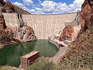
Theodore Roosevelt Dam is a dam on the Salt River located northeast of Phoenix, Arizona. The dam is 357 feet (109 m) high and forms Theodore Roosevelt Lake as it impounds the Salt River. Originally built between 1905 and 1911, the dam was renovated and expanded in 1989–1996. The dam is named after President Theodore Roosevelt. Serving mainly for irrigation, water supply, and flood control, the dam also has a hydroelectric generating capacity of 36 megawatts.

The Shoshone Project is an irrigation project in the U.S. state of Wyoming. The project provides irrigation for approximately 107,000 acres (430 km2) of crops in the Big Horn Basin, fulfilling the vision of local resident and developer Buffalo Bill Cody, who hoped to make the semi-arid basin into agricultural land. Buffalo Bill Dam on the Shoshone River impounds water for the project in Buffalo Bill Reservoir. In addition to its role in irrigation, the project provides flood control on the Shoshone and generates power, using the 350-foot (110 m) height of Buffalo Bill Dam, once a world record, and the considerable fall of the river through Shoshone Canyon to generate hydroelectric power. Chief crops in the Big Horn Basin are sugar beets, alfalfa, barley, oats, corn and beans.
Buffalo Bill State Park is a public recreation area surrounding the reservoir formed by the Buffalo Bill Dam, an impoundment of the Shoshone River, in Park County, Wyoming. The state park, reservoir and dam were named after William "Buffalo Bill" Cody, who founded the nearby town of Cody and who owned much of the land now occupied by the reservoir and park. The park offers camping, hiking, boating, fishing, and picnicking and is managed by Wyoming Division of State Parks and Historic Sites.

Navajo Dam is a dam on the San Juan River, a tributary of the Colorado River, in northwestern New Mexico in the United States. The 402-foot (123 m) high earthen dam is situated in the foothills of the San Juan Mountains about 44 miles (71 km) upstream and east of Farmington, New Mexico. It was built by the U.S. Bureau of Reclamation (Reclamation) in the 1960s to provide flood control, irrigation, domestic and industrial water supply, and storage for droughts. A small hydroelectric power plant was added in the 1980s.

Yellowtail Dam is a dam across the Bighorn River in south central Montana in the United States. The mid-1960s era concrete arch dam serves to regulate the flow of the Bighorn for irrigation purposes and to generate hydroelectric power. The dam and its reservoir, Bighorn Lake, are owned by the U.S. Bureau of Reclamation.
Buffalo Bill Dam is a concrete arch-gravity dam on the Shoshone River in the U.S. state of Wyoming. It is named after the famous Wild West figure William "Buffalo Bill" Cody, who founded the nearby town of Cody and owned much of the land now covered by the reservoir formed by its construction. The dam is part of the Shoshone Project, successor to several visionary schemes promoted by Cody to irrigate the Bighorn Basin and turn it from a semi-arid sagebrush-covered plain to productive agricultural land. Known at the time of its construction as Shoshone Dam, it was renamed in 1946 to honor Cody.

The Colorado River Storage Project is a United States Bureau of Reclamation project designed to oversee the development of the upper basin of the Colorado River. The project provides hydroelectric power, flood control and water storage for participating states along the upper portion of the Colorado River and its major tributaries.
Dry Falls Dam is a rockfaced earthfill type dam in the U.S. state of Washington. Located in Grant County near Coulee City, it was built as part of the Bureau of Reclamation's Columbia Basin Project. Water from the Columbia River, impounded by Grand Coulee Dam, is pumped into Grand Coulee, a formerly dry canyon, through the short Feeder Canal. Grand Coulee's north end is sealed by North Dam and Dry Falls Dam stretches across the midsection of the Coulee. This allows the water pumped from the Columbia River to fill the upper Grand Coulee, creating a large equalizing reservoir known as Banks Lake. Water from the reservoir is fed into the irrigation project's Main Canal, which runs south from Dry Falls Dam to another reservoir called Billy Clapp Lake, formed by Pinto Dam.

The Minidoka Project is a series of public works by the U.S. Bureau of Reclamation to control the flow of the Snake River in Wyoming and Idaho, supplying irrigation water to farmlands in Idaho. One of the oldest Bureau of Reclamation projects in the United States, the project involves a series of dams and canals intended to store, regulate and distribute the waters of the Snake, with electric power generation as a byproduct. The water irrigates more than a million acres (4,000 km²) of otherwise arid land, producing much of Idaho's potato crop. Other crops include alfalfa, fruit and sugar beets. The primary irrigation district lies between Ashton in eastern Idaho and Bliss in the southwestern corner of the state. Five main reservoirs collect water, distributing it through 1,600 miles (2,600 km) of canals and 4,000 miles (6,400 km) of lateral distribution ditches.

Anchor Dam is a dam in Hot Springs County, about 35 miles (56 km) west of Thermopolis, Wyoming.
Big Sandy Dam is a dam in Sweetwater County, Wyoming, about ten miles north of Farson.

Bonny Dam is a dam in Yuma County, Colorado, in the eastern part of the state.

Angostura Dam is an embankment dam across the Cheyenne River in Fall River County in southwestern South Dakota in the United States, about 75 miles (121 km) south of Rapid City. The dam consists of an earth-fill embankment with a concrete spillway section, 193 feet (59 m) high and 2,030 feet (620 m) long; it withholds the 195,121-acre-foot (0.240678 km3) Angostura Reservoir. The dam was conceived as early as 1913, but it was not until the 1930s when a regional drought caused crop failures that the project received widespread support from farmers. Built from 1946 to 1949, the dam is part of the Angostura Division of the Pick-Sloan Missouri Basin Program, and is operated by the U.S. Bureau of Reclamation.
Pilot Butte Dam is a dam in Fremont County, Wyoming.
References
- ↑ "Project details - Riverton Unit - Bureau of Reclamation". Archived from the original on 2012-09-25. Retrieved 2012-08-01.
- ↑ "Midvale Irrigation District: Project Features". Archived from the original on 2013-10-11. Retrieved 2012-08-01.
- ↑ "Bull Lake". Archived from the original on 2012-10-13. Retrieved 2012-08-01.
- ↑ "Archived copy" (PDF). Archived from the original (PDF) on 2019-03-24. Retrieved 2019-03-24.
{{cite web}}: CS1 maint: archived copy as title (link)