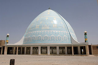
Kandahar is a city in Afghanistan, located in the south of the country on the Arghandab River, at an elevation of 1,010 m (3,310 ft). It is Afghanistan's second largest city after Kabul, with a population of about 614,118. It is the capital of Kandahar Province and the centre of the larger cultural region called Loy Kandahar. Kandahar is the founding city and spiritual center of the Taliban. Despite the capital of Afghanistan being Kabul, where the government administration is based, Kandahar is the seat of power in Afghanistan as the supreme leader and his spiritual advisers are based there. Kandahar has therefore been called the de facto capital of Afghanistan, though the Taliban maintain Kabul is the capital.

The Helmand River is the longest river in Afghanistan and the primary watershed for the endorheic Sistan Basin. It emerges in the Sanglakh Range of the Hindu Kush mountains in the northeastern part of Maidan Wardak Province, where it is separated from the watershed of the Kabul River by the Unai Pass. The Helmand feeds into the Hamun Lake on the border between Afghanistan and Iran.

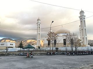
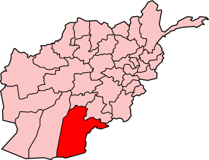
Kandahār is one of the thirty-four provinces of Afghanistan, located in the southern part of the country, sharing a border with Pakistan, to the south. It is surrounded by Helmand in the west, Uruzgan in the north and Zabul Province in the east. Its capital is the city of Kandahar, Afghanistan's second largest city, which is located on the Arghandab River. The greater region surrounding the province is called Loy Kandahar. The Emir of Afghanistan sends orders to Kabul from Kandahar making it the de facto capital of Afghanistan, although the main government body operates in Kabul. All meetings with the Emir take place in Kandahar, meetings excluding the Emir are in Kabul.
Quetta is a district in the north-west of the Balochistan province of Pakistan, on the border with Kandahar province, Afghanistan. It is part of Quetta Division. The district is famous for its agriculture produce, most notably fruit orchards but also including apples and grapes. The Hanna Valley is an area where almonds are grown. The population counted in the 1998 census was 760,000, while in 2010 it was estimated at 1,235,000.

The Arghandab is a river in Afghanistan, about 400 km (250 mi) in length. It rises in Ghazni Province, west of the city of Ghazni, and flows southwest, passing near the city of Kandahar, before joining the Helmand River 30 km (19 mi) below the town of Grishk. In its lower course, it is much used for irrigation, under the control of the Helmand and Arghandab Valley Authority, and the valley is cultivated and populous; yet the water is said to be somewhat brackish. It is doubtful whether the ancient Arachotus is to be identified with the Arghandab or with its chief confluent the Tarnak, which joins it on the left 50 km (31 mi) southwest of Kandahar. The Tarnak, which flows south of Kandahar, is much shorter and less copious.
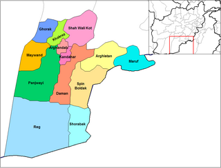
Panjwayi is a district in Kandahar Province, Afghanistan. It is located about 35 kilometres (22 mi) west of Kandahar. The district borders Helmand Province to the southwest, Maywand District to the west, Zhari District to the north, Arghandab, Kandahar and Daman districts to the east and Reg District to the south. Panjwayi was reduced in size in 2004 when Zhari District was created out of the northern part of it, on the northern side of the Arghandab River, which now forms the northern boundary.
Arghandab is a district in the central part of Kandahar Province, Afghanistan. It borders Panjwai and Khakrez districts to the west, Shah Wali Kot District to the north and east and Kandahar District to the east and south.
Zhari is a district in Kandahar Province, Afghanistan. Alternative spellings include Zheley, Zharey, Zharay, Zheri, or Zheray. The district was created in 2004 from land that was formerly part of Maywand and Panjwai districts. The population is estimated at 80,700 (2010).
Nesh is a mountainous district in the northern part of Kandahar Province, shifted from Oruzgan Province, Afghanistan. It borders Oruzgan Province to the west, north and east and Shah Wali Kot, Khakrez and Ghorak districts to the south. The population is 14,884 (2019). The district center is the village of Naish, located in the central part of the district.
Ghorak district is situated in the northwestern part of Kandahar Province, Afghanistan. It borders Helmand Province to the West, Oruzgan Province and Naish District to the North, Khakrez District to the East and Maywand District to the South. The population is 8,600 (2006). The district center is the village of Ghorak, located in its western part.

Maiwand is a village in Afghanistan within the Maywand District of Kandahar Province. It is located 50 miles northwest of Kandahar, on the main Kandahar–Lashkargah road.
Shīnḍanḍ is a town and the center of the Shindand District, Herat Province, Afghanistan. It is located at 33.3036°N 62.14°E at 1,066 m altitude on the Harut River. The Shindand Air Base is located about 15 miles northeast of the town.

Khakrez District is a rural agrarian community with a population of more than 20,000 located in north-central Kandahar Province. A village known variously as Khakrez or Darvishan, at the base of mountains in the western part of the district, is the location of the district center building and the Shah Agha Shrine or Shah Maqsud Shrine, one of the oldest historical Islamic sites in Afghanistan.

Khakrez, also written Khakriz and Khak Reiz, is a village and the district center of Khakrez District, Kandahar Province, Afghanistan. It is located at the base of a mountain range in the western part of the district at 31.9856°N 65.4728°E and 1,516 m altitude. It is also known as Darvishan. Khakrez is the location of the district center building and the Shah Agha Shrine or Shah Maqsud Shrine, one of the oldest historical Islamic sites in Afghanistan.

The Tarnak River is located in Ghazni, Zabul, and Kandahar provinces of Afghanistan. The city of Kandahar is located on a plain directly adjacent to the Tarnak.
Operation Shahi Tandar, also called Operation Atal, was a series of operations by Coalition troops from the British 42 Commando Royal Marines, Royal Canadian Regiment, 2nd Battalion 2nd Infantry Regiment, and the Afghan national military in central Helmand province and the Western Panjwayi and Western Zhari districts of Kandahar, Afghanistan from January 7–31, 2009.
The 2001 Bombing of Kandahar was a series of military operations conducted in and around Kandahar, Afghanistan, during October 2001, as part of the start of the United States' military operations in Afghanistan.
Walakan is a village in Kandahar Province, in southern Afghanistan. It is situated 5 miles southwest of Kandahar, 1 mile west of Karezak. Walakan is said to have been one of four villages given to the original Parsiwan inhabitants. Walakan, along with Zalakhan is said to have been part of sector which the Soviets left unguarded during the war.
