
Kashmir is the northernmost geographical region of the Indian subcontinent. Until the mid-19th century, the term "Kashmir" denoted only the Kashmir Valley between the Great Himalayas and the Pir Panjal Range. The term has since come to encompass a larger area that includes the India-administered territories of Jammu and Kashmir and Ladakh, the Pakistan-administered territories of Azad Kashmir and Gilgit-Baltistan, and the Chinese-administered territories of Aksai Chin and the Trans-Karakoram Tract.

Baltistan; also known as Baltiyul or Little Tibet, is a mountainous region in the Pakistani-administered territory of Gilgit-Baltistan and constitutes a northern portion of the larger Kashmir region that has been the subject of a dispute between India and Pakistan since 1947. It is located near the Karakoram and borders Gilgit to the west, China's Xinjiang to the north, Indian-administered Ladakh to the southeast, and the Indian-administered Kashmir Valley to the southwest. The average altitude of the region is over 3,350 metres (10,990 ft). Baltistan is largely administered under the Baltistan Division.

Gilgit is a city in Pakistani-administered Gilgit–Baltistan in the disputed Kashmir region. It is the capital of the Gilgit-Baltistan region. The city is located in a broad valley near the confluence of the Gilgit and the Hunza rivers. It is a major tourist destination in Pakistan, serving as a hub for trekking and mountaineering expeditions in the Karakoram mountain range.

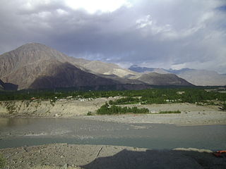
Skardu is a city located in Pakistan administered Gilgit-Baltistan in the disputed Kashmir region. Skardu serves as the capital of Skardu District and the Baltistan Division. It is situated at an average elevation of nearly 2,500 metres above sea level in the Skardu Valley, at the confluence of the Indus and Shigar rivers. It is an important gateway to the eight-thousanders of the nearby Karakoram mountain range. The Indus River running through the region separates the Karakoram from the Ladakh Range.

The Northern Light Infantry Regiment (NLI) is a light infantry regiment in the Pakistan Army, based and currently headquartered in Gilgit, Pakistan. Along with other forces of the Pakistani military, the NLI has the primary responsibility of conducting ground operations in the interest of defending the strategically-important territory of Gilgit−Baltistan, a Pakistani-controlled region that constitutes part of Kashmir, which has been disputed between Pakistan and India since 1947. The NLI draws a majority of its recruits from native tribes present in the nearby mountainous areas who are reportedly less prone to altitude sickness and the cold temperatures that characterize high-altitude mountain warfare, allowing the regiment to conduct its duties optimally.

The Gilgit Agency was an agency within the British Indian Empire. It encompassed the subsidiary states of the princely state of Jammu and Kashmir situated along the northern border. The primary objective of establishing the Gilgit Agency was to bolster and fortify these regions, particularly in the context of concerns about Russian encroachment in the area. The subsidiary states encompassed Hunza, Nagar and other states in the present day districts of Gupis-Yasin, Ghizer, Darel, Tangir and Diamer. The agency headquarters was based in the town of Gilgit, within the Gilgit tehsil of Jammu and Kashmir.
The Gilgit District is one of the 14 districts of Pakistan-administered territory of Gilgit-Baltistan in the disputed Kashmir region. The headquarters of the district is the town of Gilgit. At the 1998 census, the Gilgit District had a population of 243,324. The district includes Gilgit, the Bagrot Valley, Juglot, Danyore, Sultanabad, Naltar Peak, and the Nomal Valley. The highest peak in the district is Distaghil Sar 7,885 metres (25,869 ft), which is the seventh-highest peak in Pakistan and 19th highest in the world.
Diamer District, also spelled Diamir District,) is a district in the Gilgit-Baltistan region administered by Pakistan. The headquarters of the district is the town of Chilas. The district is bounded on the north by the Tangir and the Gilgit districts, on the east by the Astore District, on the south by the Mansehra district of Pakistan's Khyber Pakhtunkhwa Province and the Neelum District of Pakistan controlled Kashmir, and on the west by the Upper Kohistan District of Khyber Pakhtunkhwa Province. The Karakoram Highway passes through Diamer District.

Astore District is a district of Pakistan-administered Gilgit-Baltistan in the disputed Kashmir region. It is one of the 14 districts of the Pakistani-administered territory of Gilgit−Baltistan. Its administrative headquarters are located at Eidgah in the Astore Valley. Astore District is bounded by Gilgit District to the north, Roundu District to the northeast, Skardu District to the east, Kharmang District to the southeast, Diamer District to the west, the Neelum District of Azad Jammu and Kashmir to the southwest, and the Bandipore District of Indian-administered disputed Kashmir region to the south.

Gilgit-Baltistan, formerly known as the Northern Areas, is a region administered by Pakistan as an administrative territory and consists of the northern portion of the larger Kashmir region, which has been the subject of a dispute between India and Pakistan since 1947 and between India and China since 1959. It borders Azad Kashmir to the south, the province of Khyber Pakhtunkhwa to the west, the Wakhan Corridor of Afghanistan to the north, the Xinjiang region of China to the east and northeast, and the Indian-administered union territories of Jammu and Kashmir and Ladakh to the southeast.
Juglot or Jaglot is a town located in the Gilgit District of Gilgit-Baltistan region in Pakistan. It is situated 45 kilometres (28 mi) southeast of the regional capital city of Gilgit on the Karakoram Highway. The town is situated at the junction of three major mountain ranges: the Karakoram, the Hindu Kush and the Himalayas. The confluence of the Gilgit and Indus river is also located nearby.

The Gilgit Scouts was a paramilitary force within the Gilgit-Baltistan region in northern Pakistan. They were raised by the British Raj in 1913, on behalf of the princely state of Jammu and Kashmir, to police the Gilgit Agency, which formed the northern frontier of British India. The force was composed of local men recruited by British commanders.
Gilgit-Baltistan is an administrative territory of Pakistan that borders the province of Khyber Pakhtunkhwa to the west, Azad Kashmir to the southwest, Wakhan Corridor of Afghanistan to the northwest, the Xinjiang Uyghur Autonomous Region of China to the north, and the Indian-administered region of Jammu and Kashmir to the south and south-east.

Chorbat Valley is a section of the Shyok river valley divided between Pakistan-administered Gilgit-Baltistan and Indian-administered Ladakh. The Pakistan-administered portion is in the Khaplu tehsil of Ghanche District in Gilgit–Baltistan, and the Indian-administered portion is in the Nubra tehsil, Leh district of Ladakh. Chorbat stretches from the edge of Khaplu to the Chalunka village of Nubra.
Mirza Hassan Khan , of Majini Mohallah Gilgit, was a captain of the 6th Infantry of the Jammu and Kashmir State Forces. Placed at Bunji in the Gilgit wazarat, Khan rebelled against the Maharaja's regime after his accession to India and participated in the overthrow of the governor of Gilgit in November 1947. He later fought in the First Kashmir War as part of Gilgit rebel forces under the command of Colonel Aslam Khan and rose to become a colonel in the Pakistan Army. After leaving the army, he founded the Gilgit League to protest against the Pakistan's ad-hoc administration of Gilgit-Baltistan.

The Jammu–Sialkot line was a 43 km (27 mi) broad gauge branch of the North Western State Railway from Wazirabad Junction, Punjab, to Jammu, passing through the Sialkot Junction. The section from Sialkot to Jammu was 27 miles (43 km) long, partly in the British Indian province of Punjab and partly in the princely state of Jammu and Kashmir Built in 1890 during the reign of Maharaja Pratap Singh, it was the first railway line in the state of Jammu and Kashmir.

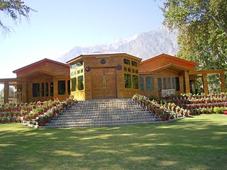
Muhammad Aslam Khan better known as Colonel Pasha, The Legend of Baltistan, and Laji, was a former one-star rank Pakistan Army officer, businessman, and founder of the Shangrila Resort. Notably, as the leader of 'D' Company, he led his troops during World War II in capturing Kennedy Peak (Myanmar), which the Americans had failed to conquer. For this achievement, he was awarded the Military Cross by Field Marshal Auchinleck.
Bunji (Urdu:بنجی) is a town in Astore District of Gilgit-Baltistan region in Pakistan. It was historically important, being on the edge of the ancient Yagistan. It was economically a hub for barter trade between Yagistan and Dogras. The distance from Bunji to Gilgit is about 50 kilometres (31 mi) on the Karakoram Highway. Bunji, located at the junction of three Great Mountain Ranges, has its historical importance. The village has its prominent traces in the socio-political and economical situations of the region in History. Literacy rate of bunji is almost 100 percent except outsider coming from other places for jobs. River Indus covers the village from North to west while from eastern side it is connected with river Astore. Baltistan region joins its territory from the North-East.

In November 1947, the paramilitary force of Gilgit Scouts stationed at Gilgit rebelled against the princely state of Jammu and Kashmir, soon after it acceded to the Indian Union. Under the command of a British officer Major William Brown, they executed a coup d'etat, overthrew the governor Ghansara Singh, and imprisoned him. The Muslim troops of Jammu and Kashmir State Forces stationed at Bunji joined in the rebellion, under the command of Captain Mirza Hassan Khan, imprisoned their own commander Colonel Abdul Majid and eliminated the non-Muslim troops. A provisional government was declared under a local chief Shah Rais Khan, which lasted for about two weeks. On 16 November, a Pakistani political agent Khan Mohammad Alam Khan arrived and took over the administration.

The Action at Tsari occurred during the Indo-Pakistani war of 1947–1948 in the Gilgit-Baltistan sector at Tsari, on the banks of the Indus River near Skardu, from 11 to 12 February 1948. The conflict involved the Gilgit Scouts and the Jammu and Kashmir forces. The Ibex Force of the Gilgit Scouts, led by Major Ehsan, planned an attack on the Tsari outposts along the Indus River. These outposts had been established by Colonel Sher Jung Thapa as a defensive measure and to warn the Skardu garrison in case of an assault. Upon the arrival of the Gilgit Scouts, the Muslim troops stationed at the state forces' outpost, including their commander, Captain Nek Alam, defected to the Gilgit Scouts.

