
The Shire of Burdekin is a local government area located in North Queensland, Australia in the Dry Tropics region. The district is located between Townsville and Bowen in the delta of the Burdekin River.

The Burdekin River is a river located in North and Far North Queensland, Australia. The river rises on the northern slopes of Boulder Mountain at Valley of Lagoons, part of the western slope of the Seaview Range, and flows into the Coral Sea at Upstart Bay over 200 kilometres (124 mi) to the southeast of the source, with a catchment area of approximately 130,000 square kilometres (50,000 sq mi). The Burdekin River is Australia's largest river by (peak) discharge volume.

Ayr is a town and locality in the Shire of Burdekin, Queensland, Australia. It is the centre of a sugarcane-growing region and the administrative centre for the Burdekin Shire Council. In the 2016 census, Ayr had a population of 8,738 people.

Home Hill is a rural town and locality in the Shire of Burdekin, Queensland, Australia. In the 2016 census, the locality of Home Hill had a population of 2,954 people.

The Burdekin Bridge spans the Burdekin River between the towns of Ayr to the north and Home Hill to the south, both in the Shire of Burdekin, Queensland, Australia. Located on the Bruce Highway which is part of Highway 1, it is an important link in the national road network. It is a road-rail bridge which provides high flood immunity link between north and south Queensland.

North Queensland or the Northern Region is the northern part of the Australian state of Queensland that lies just south of Far North Queensland. Queensland is a massive state, larger than many countries, and its tropical northern part has been historically remote and undeveloped, resulting in a distinctive regional character and identity.

The Burdekin Dam, officially the Burdekin Falls Dam, is a concrete gravity dam with an uncontrolled spillway across the Burdekin River, located south west of Ayr, and Home Hill in North Queensland, Australia. Built for the purpose of irrigation, the reservoir, called Lake Dalrymple. Burdekin Dam is managed by SunWater. Water from the reservoir is also used to replenish downstream aquifers.

The Somerset Region is a local government area located in the West Moreton region of South East Queensland, Australia, about 100 kilometres (62 mi) northwest of Brisbane and centred on the town of Esk. It was created in 2008 from a merger of the Shire of Esk and the Shire of Kilcoy. It is commonly known as the Brisbane Valley, due to the Brisbane River which courses through the region, although significant parts of the region lie outside the hydrological Brisbane Valley itself.

Dalbeg is a rural town and locality in the Shire of Burdekin, Queensland, Australia. In the 2016 census, Dalbeg had a population of 76 people.
Brandon is a rural town and locality in the Shire of Burdekin, Queensland, Australia. In the 2016 census, Brandon had a population of 1,094 people.

Millaroo is a rural town and locality in the Shire of Burdekin, Queensland, Australia. In the 2016 census the locality of Millaroo had a population of 96 people.
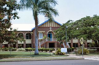
Ayr State High School is a heritage-listed state secondary school at 82-90 Wickham Street, Ayr, Shire of Burdekin, Queensland, Australia. It is one of three high schools in Ayr, the others being Burdekin Catholic High School and Burdekin Christian College. Ayr State High School was designed by Department of Public Works (Queensland) and built from 1935 to 1937. It was also known as Ayr State High and Intermediate School. It was added to the Queensland Heritage Register on 13 January 1995.
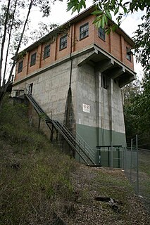
North Pine Pumping Station is a heritage-listed pumping station at Lake Kurwongbah-Dayboro Road, Kurwongbah, Moreton Bay Region, Queensland, Australia. It was built from 1956 to 1961 by K D Morris & Sons Pty Ltd. It is also known as Dayboro Road Pumping Station. It was added to the Queensland Heritage Register on 28 January 2009.
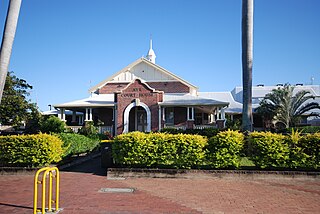
Ayr Court House is a heritage-listed courthouse at 163 Queen Street, Ayr, Shire of Burdekin, Queensland, Australia. It was designed by Douglas Francis Woodcraft Roberts and built from 1935 to 1941 by day labour. It was added to the Queensland Heritage Register on 13 January 1995.

Burdekin Shire Council Chambers is a heritage-listed town hall at 145 Young Street, Ayr, Shire of Burdekin, Queensland, Australia. It was designed by Frederick Smith and built in 1937 by local builder AS Wight. It is also known as Ayr Shire Council Chambers. It was added to the Queensland Heritage Register on 13 October 1997.

St Patrick's Catholic Church is a heritage-listed former Roman Catholic church at 27 Spiller Street, Brandon, Shire of Burdekin, Queensland, Australia. It was built in 1910. It is also known as Burdekin Academy of Dance. It was added to the Queensland Heritage Register on 21 October 1992.

Cyclone Leonta was a tropical cyclone that caused severe damage in North Queensland on 9 March 1903. It lasted for around twelve hours, and was the most damaging cyclone ever to hit Townsville at that time, surpassing Cyclone Sigma of 1896, with approximately 14 lives lost. It caused approximately £250,000 damage in 1903 terms.

Burdekin River Pumping Station is a heritage-listed pumping station at Weir Road, Breddan, Charters Towers Region, Queensland, Australia. It was built from c. 1887 to 1910s. It is also known as Charters Towers Water Supply Scheme. It was added to the Queensland Heritage Register on 3 July 1995.
McDesme is a rural locality in the Shire of Burdekin, Queensland, Australia. In the 2016 census McDesme had a population of 277 people.