
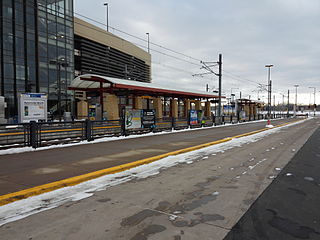
The Metro Blue Line is a 12-mile (19.3 km) light rail line in Hennepin County, Minnesota that extends from downtown Minneapolis to the southern suburb of Bloomington. The line was originally named after Hiawatha Avenue which runs parallel to a good portion of the line. Major locations on the line include the Mall of America, Minneapolis–St. Paul International Airport and Target Field in downtown Minneapolis.
Metro Transit is the primary public transportation operator in the Minneapolis–Saint Paul area of the U.S. state of Minnesota and the largest operator in the state. Although Metro Transit is one of the smallest transit systems for a large metropolitan area in the United States, it is ranked as one of the best. In 2021, the system had a ridership of 32,748,300, or about 119,400 per weekday as of the second quarter of 2022.

The Metro Green Line is an 11-mile (18 km) light rail line that connects the central business districts of Minneapolis and Saint Paul in Minnesota as well as the University of Minnesota. An extension is under construction that will extend the line to the southwest connecting St. Louis Park, Hopkins, Minnetonka and Eden Prairie. The line follows the path of former Metro Transit bus route 16 along University Avenue and Washington Avenue. It is the second light-rail line in the region, after the Blue Line, which opened in 2004 and connects Minneapolis with the southern suburb of Bloomington.
Lake Street/Midtown station, also referred locally as just Midtown station, is a Blue Line light rail station in Minneapolis, Minnesota, United States.
30th Avenue station is a light rail and bus station on the Blue Line in the Twin Cities region of the U.S. state of Minnesota. The station opened with the Blue Line light rail on December 4, 2004, and the Red Line began service at the station on June 22, 2013. It has a 1,443-space park and ride facility. The south parking lot was closed for construction of a 1,443 space parking ramp, which opened in Fall 2008.

The Minnesota Valley Transit Authority, also known by the acronym MVTA, is a public transportation agency that serves seven communities in the southern portion of the Minneapolis–Saint Paul metropolitan area. The agency provides fixed-route and demand-responsive transit within the service area of the communities and to select destinations in the region.

The METRO Red Line is a bus rapid transit line between the Twin Cities suburbs of Bloomington, Minnesota and Apple Valley, Minnesota. The Red Line travels primarily on Minnesota State Highway 77 and Cedar Avenue from the Apple Valley station in Apple Valley, north through Eagan, Minnesota, to the Mall of America station in Bloomington where it connects to the Metro Blue Line. The line has bus rapid transit elements including bus-only lanes, specially branded vehicles, transit signal priority, and dedicated stations.

Plymouth Metrolink is the public transit system that serves Plymouth, Minnesota. Metrolink operates fixed-route bus routes Monday-Friday during peak periods with limited midday service. Most routes serve downtown Minneapolis and the University of Minnesota with one route providing reverse commute service from Minneapolis to employers in Plymouth. Demand-responsive bus service is available seven days a week. Most buses are provided by the Metropolitan Council with First Transit operating the fixed-route service.
The U of M Transitway is a busway that runs between the University of Minnesota's Minneapolis and St. Paul campuses. Use of the roadway is limited to buses, bicycles, and emergency vehicles. The University of Minnesota runs zero-fare buses along the busway connecting the two campuses, primarily the Campus Connector but also shuttles to and from the St. Paul campus for football games. A bicycle trail runs alongside the transitway for most of its distance. Between the endpoints, there are only two intersections with stoplights controlling busway traffic at Energy Park Drive and Como Avenue. The stoplights are designed to normally give the buses priority, so it is possible for many buses to run the length of the transitway without stopping.

The METRO Orange Line is a bus rapid transit line in the Twin Cities, Minnesota operated by Metro Transit. The line operates primarily along Interstate 35W from downtown Minneapolis through Richfield and Bloomington before terminating in Burnsville, Minnesota. The Orange Line provides access to 198,000 jobs with roughly a quarter of them outside downtown Minneapolis. The route serves a mix of stations located in the center of the highway, stations near highway exits, and on-street stations. The line has features typical of bus rapid transit systems with off-board fare payment, articulated buses with extra doors, stations with improved passenger amenities, and transit-only bus lanes on portions of the route.

The Apple Valley Transit Station is a transit facility located in Apple Valley, Minnesota. It is owned by the City of Apple Valley and the MVTA. The transit station is near Cedar Avenue and Gaslight Drive. This station has 337 parking spaces and is almost full almost each weekday. It also serves the nearby communities of Lakeville and Farmington.

The Eagan Transit Station is a transit facility located in Eagan, Minnesota. Riders also hail from the nearby communities of Mendota Heights and Northern Rosemount. The Park & Ride lot has 750 parking spaces for bus passengers and retail employees.
The Cedar Grove Transit Station is a transit facility in Eagan, Minnesota. It serves the Minnesota Valley Transit Authority bus system and the Metro Red Line bus rapid transit system. It opened March 20, 2010 in the Cedar Grove community.
I-35W & 46th Street is a Metro Orange Line station located in Minneapolis, Minnesota. The centerline bus rapid transit station was constructed as part of the I-35W/Minnesota State Highway 62 Crosstown Commons reconstruction project and opened in 2010. Consisting of two levels on both a local street bridge, East 46th Street, and in the median of Interstate 35W, the station was the first of its kind in Minnesota. The station allows for transit service to serve local riders without exiting the freeway and rejoin the region's high occupancy toll lane system, E-ZPass Minnesota. The station was designed in anticipation of full bus rapid transit service along I-35W to downtown Minneapolis, a vision that was realized in 2021 with the opening of the Metro Orange Line. The station cost $4.5 million to build.

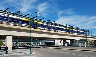
I-35W & Lake Street is a bus rapid transit station along the METRO Orange Line and planned METRO B Line in Minneapolis, Minnesota. It replaced an inconvenient pair of on-highway bus stops along the outside lanes of I-35W at Lake Street. The station itself cost $20 million and was built as part of the 35W@94: Downtown to Crosstown reconstruction project. The new two-story station is located between I-35W over Lake Street with a transit plaza on Lake Street with a landscaped ramp connecting it to the Midtown Greenway. The old bus stops were not compliant with the Americans with Disabilities Act (ADA) since stairways were the only way pedestrians were able to access the freeway stops to and from Lake Street below. The new station will be ADA-compliant with four elevators for a seamless transition between either side of the busway platforms and Lake Street platforms.

Metro is a transit network in Minnesota serving the cities of Minneapolis and Saint Paul. It also provides service to some suburban areas. As of 2021 the system consists of two light rail lines and four bus rapid transit (BRT) lines all of which are operated by the local public transit company: Metro Transit. The five lines connect Downtown Minneapolis and St Paul with the Bloomington, Minneapolis-St Paul International Airport, Roseville, Richfield, Burnsville and Brooklyn Center.

The METRO C Line is a bus rapid transit line in Brooklyn Center and Minneapolis, Minnesota operated by Metro Transit. The line is part of Metro Transit's METRO network of light rail and bus rapid transit lines. The route operates from the Brooklyn Center Transit Center along Penn Avenue and Olson Memorial Highway, terminating in downtown Minneapolis. The route is analogous to the existing Route 19 and is projected to increase ridership on this corridor from 7,000 to 9,000 by 2030. Eventually, part of its route will shift south to Glenwood Avenue from Olson Memorial Highway.

SouthWest station is a park and ride facility and a transit hub with two bus platforms for SouthWest Transit in Eden Prairie, Minnesota. The station is being reconfigured to include a light rail station on the METRO Southwest LRT, which is an extension of the Green Line. The station is located on Technology Drive in Eden Prairie, just north of the Purgatory Creek wetland area and south of U.S. Route 212. In December 2018 the Metropolitan Council purchased the station from SouthWest Transit for $8 million. The Metropolitan Council's 2021 park-and-ride system report found 156 cars parked at the station compared to 829 in 2019 before the COVID-19 pandemic.

Burnsville Heart of the City is a bus rapid transit station along the METRO Orange Line and its southern terminal. The station is located at the corner of Minnesota State Highway 13 in the downtown of Burnsville, Minnesota. The station is located between Minnesota Valley Transit Authority's (MVTA) Burnsville Transit Station and Heart of the City Park and Ride, providing bus connections and park and ride capacity.

The Marq2 transit corridor is a north-south thoroughfare in the U.S. city of Minneapolis that consists of the parallel streets of Marquette and Second avenues in the downtown area. Each public streetway has two contraflow bus lanes with two lanes available for general purpose traffic in the opposite direction. Vehicular transit flows south on Marquette Avenue and north on 2nd Avenue. The inner curb lane allows buses to stop for riders while the second bus only lane allows buses to pass each other along the corridor. Bus routes that operate on the corridor stop at every other block at an assigned gate with each route assigned a northbound and southbound gate. Gates are assigned letters A, B, C, or D on Marquette Avenue and E, F, G, and H on Second Avenue. Custom bus shelters are installed at each stop with heaters and real time transit information. The corridor primarily serves express buses operated by all five public transit agencies in the Twin Cities.
