HMS Colossus was a 74-gun third-rate ship of the line of the Royal Navy. She was launched at Gravesend on 4 April 1787 and lost on 10 December 1798. During her years of service she participated in the Battle of Groix, the Battle of Cape St Vincent, and the Battle of the Nile. While carrying wounded from the latter, she was wrecked at the Isles of Scilly. The wreck is a Protected Wreck managed by Historic England.

Bryher is one of the smaller of the inhabited islands of the Isles of Scilly.

St Martin's is the northernmost populated island of the Isles of Scilly, England. It has an area of 237 hectares (0.92 sq mi).
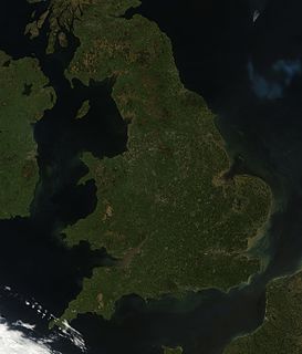
England comprises most of the central and southern two-thirds of the island of Great Britain, in addition to a number of small islands of which the largest is the Isle of Wight. England is bordered to the north by Scotland and to the west by Wales. It is closer to continental Europe than any other part of mainland Britain, divided from France only by a 33 km (21 mi) sea gap, the English Channel. The 50 km (31 mi) Channel Tunnel, near Folkestone, directly links England to mainland Europe. The English/French border is halfway along the tunnel.
The Minnehaha was a barque built in 1857 and wrecked on 18 January 1874 in the Isles of Scilly.

Annet is the second largest of the fifty or so uninhabited Isles of Scilly, 1 kilometre (0.62 mi) west of St Agnes with a length of 1 kilometre (0.62 mi) and approximately 22 hectares in area. The low-lying island is almost divided in two by a narrow neck of land at West Porth which can, at times, be covered by waves. At the northern end of the island are the two granite carns of Annet Head and Carn Irish and three smaller carns known as the Haycocks. The rocky outcrops on the southern side of the island, such as South Carn, are smaller. Annet is a bird sanctuary and the main seabird breeding site in Scilly.
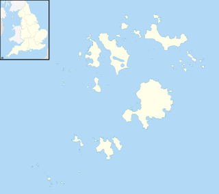
Gugh could be described as the sixth inhabited island of the Isles of Scilly, but is usually included with St Agnes with which it is joined by a sandy tombolo known as "The Bar" when exposed at low tide. The island is only about 1 km (0.62 mi) long and about 0.5 km (0.31 mi) wide, with the highest point, Kittern Hill at 34 m (112 ft). The geology consists of Hercynian granite with shallow podzolic soils on the higher ground and deeper sandy soils on the lower ground. The former Gugh farm is just north of the neck across the middle of the island between the two hills. The two houses were designed and built in the 1920s by Charles Hamlet Cooper. The name is often mispronounced as "Goo", "Guff" or even "Gogh".
The Isles of Scilly Wildlife Trust, formed in 1985, is a Wildlife Trust covering the Isles of Scilly, a group of islands off the coast of Cornwall. It became the 46th member of The Wildlife Trusts in 2001 and is dedicated to ensuring that the archaeological and historical remains on the islands, as well as the flora and fauna, are protected and maintained.

The Council of the Isles of Scilly is a sui generis unitary local government authority covering the Isles of Scilly off the west coast of Cornwall. It is currently made up of 16 seats, with all councillors being independents. The council was created in 1890 as the Isles of Scilly Rural District Council and was renamed in 1974.

Teän is an uninhabited island to the north of the Isles of Scilly archipelago between Tresco, 1.5 kilometres (0.9 mi) to the west and St Martin's 300 metres (330 yd) to the east. Approximately 16 hectares in area the island consists of a series of granite tors with the highest point, Great Hill, rising to 40 metres (130 ft) at its eastern end. The low-lying land is overlain with glacial till and outwash gravels with glacial erratics abundant on the north coast beaches which indicates the southern limit of outwash from an ice sheet for which it is designated a Geological Conservation Review site.
Firebrand was a Royal Navy fireship built at Limehouse in 1694, the first Royal Naval vessel to bear the name.

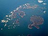
The Isles of Scilly is an archipelago off the southwestern tip of Cornwall. One of the islands, St Agnes, is the most southerly point in England, being over 4 miles (6.4 km) further south than the most southerly point of the British mainland at Lizard Point.

The birds of Cornwall are in general a selection of those found in the whole of the British Isles, though Cornwall's position at the extreme south-west of Great Britain results in many occasional migrants. The nightingale is one common English bird which is virtually absent from Cornwall.

Wingletang Down is a Site of Special Scientific Interest (SSSI) on the southern side of the island of St Agnes in the Isles of Scilly, England, UK, which is noted for its biological characteristics. The site is managed by the Isles of Scilly Wildlife Trust and is within the Isles of Scilly Heritage Coast and the Isles of Scilly Area of Outstanding Natural Beauty. It is the only site in Great Britain and Ireland for the small fern, least adder's–tongue. As of 11 September 2009 the SSSI was considered to be in ″unconditional recovering″ condition because European gorse and bramble are at unacceptable levels.

Oliver's Battery is a ruined artillery battery on the island of Tresco in the Isles of Scilly off of Cornwall, England. It was built by the Parliamentarian admiral, Sir Robert Blake, after he invaded Tresco in April 1651 during the years of the interregnum. It was used to bombard the neighbouring island of St Mary's, which was still held by an opposing Royalist army, and forced its surrender several weeks later. The battery comprised a triangle of ramparts, constructed using earth and rubble, which, combined with the natural stone features on the site, produced a substantial, if crude, fortification. It is now ruined, and owned by the Duchy of Cornwall.
The Isles of Scilly are an archipelago 45 km (28 mi) off Land's End, Cornwall. Little of the fauna on, above or in the seas surrounding the isles was described prior to the 19th century, when birds and fish started to be described. Most records of other animals date from the 20th century onwards.