
James Scott, 1st Duke of Monmouth, 1st Duke of Buccleuch, KG, PC was a Dutch-born English nobleman. Originally called James Crofts or James Fitzroy, he was born in Rotterdam in the Netherlands, the eldest illegitimate son of Charles II of England, Scotland, and Ireland with mistress Lucy Walter.

The Somerset Levels are a coastal plain and wetland area of Somerset, England, running south from the Mendips to the Blackdown Hills.

The Battle of Sedgemoor was fought on 6 July 1685 and took place at Westonzoyland near Bridgwater in Somerset, England.

The Monmouth Rebellion, also known as the Pitchfork Rebellion, the Revolt of the West or the West Country rebellion, was an attempt to overthrow James II. Prince James, Duke of York, had become King of England, Scotland, and Ireland upon the death of his elder brother Charles II on 6 February 1685. James II was a Roman Catholic and some Protestants under his rule opposed his kingship. James Scott, 1st Duke of Monmouth, the eldest illegitimate son of Charles II, claimed to be rightful heir to the throne and attempted to displace James II.

The River Cary is a river in Somerset, England.

Polden Hills in Somerset, England are a long, low ridge, extending for 10 miles (16 km), and separated from the Mendip Hills, to which they are nearly parallel, by a marshy tract, known as the Somerset Levels. They are now bisected at their western end by the M5 motorway and a railway, the Bristol and Exeter Railway, part of the Great Western Main Line.

Gordano is an area of North Somerset, in England. It has been designated as a National Nature Reserve.
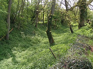
A rhyne (Somerset), rhine/rhyne (Gloucestershire), or reen is a drainage ditch, or canal, used to turn areas of wetland at around sea level into useful pasture.
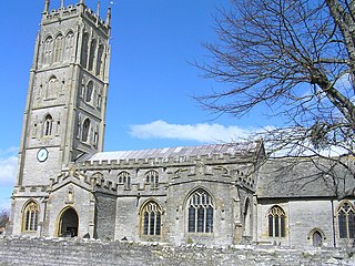
Westonzoyland is a village and civil parish in Somerset, England. It is situated on the Somerset Levels, 4 miles (6.4 km) south east of Bridgwater.

King's Sedgemoor Drain is an artificial drainage channel which diverts the River Cary in Somerset, England along the southern flank of the Polden Hills, to discharge into the River Parrett at Dunball near Bridgwater. As the name suggests, the channel is used to help drain the peat moors of King's Sedgemoor. There was opposition to drainage schemes from the local inhabitants, who feared that they would lose their common grazing rights. However, the main channel was constructed between 1791 and 1795, and despite some defects, brought some relief from flooding to the area.

Tickenham, Nailsea and Kenn Moors SSSI is a 129.4 hectare biological Site of Special Scientific Interest between Tickenham, Nailsea and Kenn on the North Somerset Levels, notified in 1995.

Langmead and Weston Level is a 168.8 hectare biological Site of Special Scientific Interest in Somerset, notified in 1991.

West Sedgemoor or West Sedge Moor is an area of the Somerset Levels, in Somerset, England, around 8 miles east of Taunton, which approximately coincides with the West Sedgemoor biological Site of Special Scientific Interest, a 1,016 hectare site notified as an SSSI in 1983. It is a flat, low-lying area of fields and meadows separated by water-filled rhynes and ditches. It is subject to controlled flooding in winter. It is drained by the River Parrett.

Westhay Moor is a 513.7-hectare (1,269-acre) biological Site of Special Scientific Interest 2.5 kilometres (1.6 mi) north-east of Westhay village and 4 kilometres (2.5 mi) from Wedmore in Somerset, England, notified in 1971. Westhay Moor is also notified as part of the Somerset Levels and Moors Special Protection Area under the EU Birds Directive and as a Ramsar Site, and a National Nature Reserve.
Brimpsfield Castle was a castle in the village of Brimpsfield in the county of Gloucestershire, England, between Gloucester and Cirencester.
Monmouthshire was a county constituency of the House of Commons of Parliament of England from 1536 until 1707, of the Parliament of Great Britain from 1707 to 1801, and of the Parliament of the United Kingdom from 1801 to 1885. It elected two Members of Parliament (MPs).

Burrow Mump is a hill and historic site overlooking Southlake Moor in the village of Burrowbridge within the English county of Somerset. It is a scheduled monument, with the ruined church on top of the hill a Grade II listed building.
Meare Pool was a lake in the Somerset Levels in South West England. Lake villages existed there in prehistoric times. During medieval times it was an important fishery, but following extensive drainage works it had disappeared from maps in the eighteenth century.

Ham Wall is an English wetland National Nature Reserve (NNR) 4 kilometres (2.5 mi) west of Glastonbury on the Somerset Levels. It is managed by the Royal Society for the Protection of Birds (RSPB). Since the last Ice Age, decomposing plants in the marshes of the Brue valley in Somerset have accumulated as deep layers of peat that were commercially exploited on a large scale in the twentieth century. Consumer demand eventually declined, and in 1994 the landowners, Fisons, gave their old workings to what is now Natural England, who passed the management of the 260 hectares Ham Wall section to the RSPB.

The Whitelake River is a small river on the Somerset Levels, England.
