Butiama District

Last updated
Butiama District
Butiama District in Mara 2022.svg
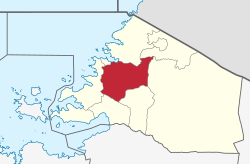
Butiama District of Mara Region
Coordinates: 01°46′S033°58′E / 1.767°S 33.967°E / -1.767; 33.967
CountryFlag of Tanzania.svg  Tanzania
Region Mara Region
Area
  Total1,962 km2 (758 sq mi)
Population
 (2022)
  Total281,656
  Density140/km2 (370/sq mi)
Website Regional website

Butiama District is one of the seven districts of Mara Region of Tanzania. It is bordered to the north by Roya District across the Kirumi Bridge on the Mara river. Its administrative centre is the town of Butiama. Julius Nyerere was born in Butiama; the Mwalimu Nyerere Museum is located in his town of birth.

Contents

According to the 2022 Tanzania National Census, the population of the Butiama District was 281,656. [1] [2]

Transport

Road

Paved Trunk road T4 from Mwanza to the Kenyan border passes through Butiama District from south to north. Trunk road T17 from Musoma to Arusha Region passes through the district from north to south. [3]


Administrative subdivisions

As of 2012, Butiama District was administratively divided into 20 wards. [2]

Wards

  • Bisumwa
  • Buhemba
  • Bukabwa
  • Buruma
  • Busegwe
  • Bumangi
  • Buswahili
  • Butiama
  • Butuguri
  • Bwiregi
  • Etaro
  • Kukirango
  • Kyanyari
  • Masaba
  • Mirwa
  • Muriaza
  • Nyakatende
  • Nyamimange
  • Nyankanga
  • Nyegina
  • Sirorisimba

Related Research Articles

<span class="mw-page-title-main">Mara Region</span> Region of Tanzania

Mara Region is one of Tanzania's 31 administrative regions. The region covers an area of 21,760 km2 (8,400 sq mi). The region is comparable in size to the combined land area of the nation state of El Salvador. The neighboring regions are Mwanza Region and Simiyu Region, Arusha Region, and Kagera Region. The Mara Region borders Kenya .The regional capital is the municipality of Musoma. Mara Region is known for being the home of Serengeti National Park, a UNESCO World Heritage site and also the birth place of Tanzania's founding father Julius Nyerere. Under British colonial occupation, the Mara Region was a district called the Lake Province, which became the Lake Region after independence in 1961.

<span class="mw-page-title-main">Bunda District</span> District in Mara Region, Tanzania

Bunda is one of the seven districts of Mara Region in the United Republic of Tanzania, East Africa. It is bordered to the north by the Musoma Rural District and Butiama District, to the east by Serengeti District, to the south by Bariadi District and Busega District, and to the west by Lake Victoria. The district administration town is also called Bunda, located on the north-south trans-national all tarmac highway from Kenya to Zambia via Tarime and the lakeside municipalities of Musoma, Mwanza, and thereon to Mbeya in southern Tanzania. The district has four divisions: Kenkombyo, Nansimo, Serengeti and Chamuriho.

<span class="mw-page-title-main">Maswa District</span> District in Simiyu Region, Tanzania

Maswa District is one of the five districts of the Simiyu Region of Tanzania Inhabited by Sukuma. It is bordered to the north by Magu District and Itilima District, to the east by the Meatu District, to the south by the Kishapu District, and to the west by the Kwimba District. Its administrative centre is the town of Maswa.

<span class="mw-page-title-main">Meatu District</span> District in Simiyu Region, Tanzania

Meatu District is one of the five districts of the Simiyu Region of Tanzania. It is bordered to the north by the Itilima District, to the west by the Maswa District and Shinyanga Region to the east by the Arusha Region, to the southeast by the Manyara Region and to the south by the Singida Region. Its district capital is the town of Mwanhuzi.

<span class="mw-page-title-main">Nzega District</span> District of Tabora Region, Tanzania

Nzega District is one of the seven districts of the Tabora Region of Tanzania. It is bordered to the north by Shinyanga Region, to the south and southwest by Uyui District and to the east by Igunga District. Its administrative seat is the town of Nzega.

<span class="mw-page-title-main">Uyui District</span> District of Tabora Region, Tanzania

Uyui District is one of the seven districts of the Tabora Region of Tanzania. It is bordered to the north by Nzega District and Igunga District as well as by the Shinyanga Region, to the south by Sikonge District, to the west by Urambo District and Kaliua District, and to the east by the Singida Region. Tabora Urban District is an enclave within the Uyui District. Its administrative seat is the city of Tabora.

<span class="mw-page-title-main">Biharamulo District</span> District in Kagera Region, Tanzania

Biharamulo District is one of the eight districts of the Kagera Region of Tanzania. It is bordered to the north by Karagwe District and Muleba District, to the east and south by Geita Region, to the west by Ngara District, and to the southwest by the Kigoma Region. Its administrative seat is Biharamulo town. Biharamulo Game Reserve is located within the borders of the district.

<span class="mw-page-title-main">Serengeti District</span> District in Mara Region, Tanzania

Serengeti District is one of the seven districts of Mara Region of Tanzania. Its administrative centre is the town of Mugumu. It is home to part of the world-famous Serengeti National Park a UNESCO World Heritage Site and contains one of the western gates to the park.

<span class="mw-page-title-main">Tarime District</span> District in Mara Region, Tanzania

Tarime District is one of the seven districts of the Mara Region of Tanzania, East Africa. It was previously known as the "North Mara District". Its district capital is Tarime town. It is bordered from the north to east by the Kenyan districts of Migori, Trans Mara and Kuria East and West Districts, and to the east by the Maasai Mara game reserve. To the south it is bordered across the Mara River by the Serengeti and Butiama districts, and to the west by Rorya District.

<span class="mw-page-title-main">Musoma Urban District</span> District in Mara Region, Tanzania

Musoma Urban District is one of the seven districts of Mara Region of Tanzania. Its capital is the town of Musoma. The district is bordered to the north by Lake Victoria and to the south by Butiama District.

<span class="mw-page-title-main">Musoma Rural District</span> District in Mara Region, Tanzania

Musoma Rural District is one of the 9 districts of Mara Region of Tanzania. Mara region has the following Districts councils: Musoma district council, Rorya district council, Tarime rural, Tarime town council, Butiama, Serengeti, Bunda rural council, Bunda town Council and Musomal Municipal council. Its administrative centre is the town of Musoma. The district is bordered to the east by Butiama District, to the south by Bunda District and to the west and north by Lake Victoria.

Butiama is a town and capital of Butiama District, located in Mara Region in northern Tanzania. The town of Butiama is the birthplace of Julius Nyerere, the founding father and the first president of Tanzania. Butiama is also the homeland of the Zanaki people, of which the founding father was a member. The Mwalimu Nyerere Museum Centre is located in the town and is the town biggest attraction.

<span class="mw-page-title-main">Singida Urban District</span> District in Singida Region, Tanzania

Singida Urban District is one of the six districts of the Singida Region of Tanzania. It is bordered to the south and west by the Ikungi District and to the north and east by the Singida Rural District. Its administrative seat is the town of Singida.

<span class="mw-page-title-main">Manyoni District</span> District in Singida Region, Tanzania

Manyoni District is one of the six districts in the Singida Region of Tanzania. The district capital is the town of Manyoni. The district is bordered to the north by the Ikungi District, to the east by the Dodoma Region, to the south by the Iringa Region, to the southwest by the Mbeya Region and to the west by the Tabora Region. In 2015 the Itigi District was created from the Manyoni District, separating the Itigi Division that was the large portion of the south western of the district.

<span class="mw-page-title-main">Rorya District</span> District in Mara Region, Tanzania

Rorya District is a district in Mara Region, United Republic of Tanzania. The district capital is the small town of Ingri Juu, while the largest town is Shirati. The district was created in 2007 from a part of Tarime District. It is bordered by Tarime District to the east, Butiama District to the south, Lake Victoria to the west, and the Republic of Kenya to the north. The majority of inhabitants are from the Luo tribe. Other ethnic group is Kurya. Kine, Simbiti,Sweta and Hacha are sub-groups within Kurya ethnic group.

<span class="mw-page-title-main">Busega District</span> District in Simiyu Region, Tanzania

Busega District is one of the five districts of Simiyu Region of Tanzania, East Africa. Its administrative centre is the town of Nyashimo. It is bordered to the north by Lake Victoria and Bunda District, to the east by Bariadi District, and to the south by Magu District.

<span class="mw-page-title-main">Itilima District</span> District in Simiyu Region, Tanzania

Itilima District is one of the five districts of Simiyu Region of Tanzania, East Africa. Its district capital is Lagangabilili. It is bordered to the north by Bariadi District, to the east by Ngorongoro District, to the south by Maswa District and Meatu District, and to the west by Magu District.

<span class="mw-page-title-main">Mbogwe District</span> District in Geita Region, Tanzania

Mbogwe District is one of the five districts of Geita Region of Tanzania. It is bordered to the north by Chato District and Geita District, to the east by Kahama Rural District and Kahama Urban District, to the south by Kahama Rural District, and to the west by Bukombe District.

Makambako Urban District is one of the six districts of the Njombe Region of Tanzania. Its administrative seat is Makambako town. It is bordered to the north and east by Mufindi District, to the south by Njombe Rural District and to the west by Wanging'ombe District.

<span class="mw-page-title-main">Chamwino District, Dodoma</span> District in Dodoma Region, Tanzania

Chamwino District is one of the seven districts of the Dodoma Region of Tanzania. It is bordered to the north by Chemba District, to the east by Manyara Region, Kongwa District and Mpwapwa District, to the south by Iringa Region, and to the west by Singida Region, Bahi District and Dodoma District. Its administrative seat is the town of Chamwino.

References

  1. "Tanzania: Administrative Division (Regions and Districts) - Population Statistics, Charts and Map". www.citypopulation.de. Retrieved 2024-02-11.
  2. 1 2 "Census 2012". National Bureau of Statistics. Archived from the original on 5 March 2016. Retrieved 9 December 2015.
  3. "Trunk and Regional Roads in Tanzania". Tanroads. Archived from the original on 8 December 2015. Retrieved 1 December 2015.