Related Research Articles

Napton on the Hill, often referred to locally as just Napton, is a village and civil parish 3 miles (4.8 km) east of Southam in Warwickshire, England. The population of the civil parish taken at the 2021 census was 1,416.

Bidford-on-Avon is a large village and civil parish in the English county of Warwickshire, very close to the border with Worcestershire. In the 2001 census it had a population of 4,830, increasing to 5,350 at the 2011 census, increasing again to 6,818 in the 2021 census.

Welford-on-Avon is a village situated some 4 miles (6 km) west-south-west of Stratford-upon-Avon in the county of Warwickshire, England. The population was measured at 1,420 in the 2011 census. Until 1931, Welford-on-Avon was in Gloucestershire, when it was transferred to Stratford-on-Avon Rural District. Since 1974 it has been part of the Stratford-on-Avon District. Welford sits within a meander of the river Avon, on the south bank of the river. The village maypole is one of the tallest in England. It used to be wooden but was replaced by an aluminium pole following a lightning strike. There are three pubs and many Tudor half-timbered and thatched cottages, mostly close to the village church, which is in the oldest part of Welford. Historically there were two railway stations within two miles of the centre of the village, Binton (1885-1949) and Milcote (1859-1966).

Bickenhill is a village in the civil parish of Bickenhill and Marston Green, in the Metropolitan Borough of Solihull, in the West Midlands county, England, on the eastern fringe of the West Midlands conurbation. Bickenhill is also a ward and was within the historic county of Warwickshire. Birmingham Airport is also located within the civil parish.

Bishop's Tachbrook is a village and civil parish in the Warwick District of Warwickshire, England. The village is about 3 miles (5 km) south of Warwick and Leamington Spa. A church at Bishop's Tachbrook is mentioned in the Domesday Book. The village contains traditional half-timbered buildings, and modern residences including council-owned terraced housing. Facilities and amenities include The Leopard public house, the oldest part of which was a morgue for the nearby crematorium, small retail outlets including a corner shop, a primary school for children aged 4 to 11, and a park which includes a BMX track.
Blackdown is a hamlet and civil parish in the Warwick district of Warwickshire, England. Blackdown is about two miles north of Leamington Spa, between Leamington, Warwick and Kenilworth. It is named Blakedon in William Dudgale's Antiquities of Warwickshire in 1656 as a district within the parish of Lillington, and as having a mill on the River Avon. Blackdown Mill on Wooton Road is Grade II listed. According to the 2001 Census it had a population of 128. From the 2011 Census population details are included with Old Milverton. Blackdown Manor is a Grade II listed house on Kenilworth Road: built in the 17th century, it was remodelled in the 19th century. Just outside the village is Quarry Park Disc Golf Club which is one of only 17 courses in the United Kingdom, and was the venue for the 2008 UK championships as well as being due to host the 2009 championships. Old Leamingtonians, the town's rugby union and Leamington Royals also play home games on the edge of the village.

Bubbenhall is a village and civil parish in the Warwick district of Warwickshire, England.
Wishaw is a village and civil parish in the north-west of Warwickshire, England. The population of the civil parish at the 2011 census was 125. It is located within the district of North Warwickshire and is the home of The Belfry golf resort, which has hosted the Ryder Cup on four occasions. The village is also home to some notable buildings. The site of The Belfry was once the location of Moxhull Park, a stately home that belonged to the Ryland family until it burnt down in the early twentieth century. The manor house was rebuilt one mile away to its present location on Holly Lane as Moxhull Hall. Wishaw is also the location of a church dedicated to the local Saint Chad. The church is popular with marriages and regular Sunday services, despite a very small local population.

Dallinghoo is a village and civil parish about three miles (5 km) north of Woodbridge, East Suffolk, Suffolk, England. In 2011 the parish had a population of 171.

Salford Priors is a rural, agricultural village and civil parish about four miles south-west of Alcester, Warwickshire, England. The population of the civil parish as taken at the 2011 census was 1,546. It is on the Warwickshire border with Worcestershire. The village is eight miles from the popular tourist town of Stratford upon Avon, the birthplace of William Shakespeare, and the River Avon runs near to it. Evesham lies seven miles to the south-west and is an important agricultural centre and soft fruit-growing area. The population of the Salford Priors ward – which includes the communities of Abbot's Salford, Dunnington, Iron Cross, Pitchill, Rushford and Mudwalls – was 1,492 at the 2001 census.
Rowington is a village and civil parish in the English county of Warwickshire. It is five miles north-west of the town of Warwick and five miles south-west of the town of Kenilworth. The parish, which also includes Lowsonford, Pinley and Mousley End, had a population of 925 according to the 2001 UK Census, increasing to 944 at the 2011 Census. The Grand Union Canal runs just south of the village and the M40 motorway is also close by. The Heart of England Way for long-distance walkers passes through the village. The parish church of St. Laurence which dates from medieval times is found on a hill in the centre of the village. In the Tudor era Rowington manor was owned by Queen Catherine Parr.

Norton Lindsey is a village and civil parish in Warwickshire, England, 3.5 miles south-west of the tourist and county town of Warwick and a mile west of the M40 motorway. At the 2011 census, the parish had a population of 326. The village takes its name from the Lindsey family who were lords of the manor in the 12th century. The parish church of the Holy Trinity dates from the following century. The village has a windmill. Two of the village's other prominent features are the Village Hall and the cricket club, which is shared with nearby Wolverton. The village also has its own Brownie pack.

Weston-on-Avon is a village in Warwickshire, England. The population of the Civil Parish taken at the 2011 census was 170. It is about 3 miles (5 km) south-west of the town of Stratford-upon-Avon.
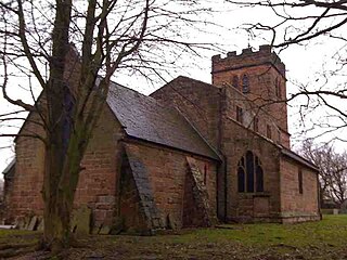
Whitchurch is a parish and a small hamlet lying on the left bank of the River Stour in Warwickshire, England, some four miles south-south-east of the town of Stratford-upon-Avon.
Priors Marston is a village and civil parish in the Stratford-on-Avon District of Warwickshire, England, 6 miles (9.7 km) southwest of Daventry. The Oxford Canal and Jurassic Way both run nearby. According to the 2001 Census the population of the parish is 506, increasing to 579 at the 2011 Census, most of whom live in the village. In the village's toponym, "Priors" records the fact the village belonged to St Mary's Priory in Coventry. "Marston" combines the Old English words Merse referring to a lake which formed a fishery in the early history of the village and tun meaning a settlement. The village has a primary school called The Priors School. The school was originally a state school, opened in 1847. However, in August 1996 the school was forced to close. After a month of intensive fundraising and planning the school re-opened, offering free education to village residents, and also accepting fee paying pupils from further afield. The school raised over £1.2m during 15 years of self-regulation until 1 September 2011, when it became one of the first of 22 new free schools to open in the United Kingdom. This returned the school to state funding but was independently managed.
Wolverton is a village in the Stratford-on-Avon District of Warwickshire, England. The population at the 2011 census was 212.

Moreton Morrell is a village and civil parish in the county of Warwickshire, England. It is part of the historic hundred of Kington and is located about three and a half miles north west of the village of Kineton. The settlement was first mentioned in the Domesday Book as Moreton. From at least Norman times, it has consisted of the village of Moreton and the hamlet of Morrell. The parish of Moreton Morrell is bounded on the east and south east by the Fosse Way, and consists of Little Morrell in the north, the village of Moreton Morrell, and Moreton Paddox in the south.

Preston on Stour is a village and civil parish in Warwickshire, England.

Ufton is a small village and civil parish in the Stratford-on-Avon District of Warwickshire, England. The population taken from the 2011 census was 319. It is 5 miles (8 km) south east of Royal Leamington Spa and 2 miles (3 km) west of Southam on the A425 road. It sits on top of a glacial escarpment 121 metres above sea level, which was formed during the last ice age. Ufton Fields, a 77-acre (31 ha) Site of Special Scientific Interest, is to the south east of the village. The parish church, which is dedicated to St Michael, dates back at least to the start of the 13th century. The Grand Union Canal is within walking distance of the village to the north.

Shuttington is a village and civil parish in North Warwickshire, England, situated north-east of Tamworth, Staffordshire. In the 2001 census, the parish, which also includes Alvecote, had a population of 563, decreasing to 536 at the 2011 census. The River Anker flows through the parish, with Shuttington north-east of the river, and Alvecote south of it. The West Coast Main Line passes through Alvecote, with the Coventry Canal parallel to it and a marina south of the canal. Most of the parish is rural, including the village of Shuttington, although there was colliery alongside the railway at Alvecote.
References
- ↑ "Civil Parish population 2011" . Retrieved 26 December 2015.