
Butte County is a county located in the northern part of the U.S. state of California. In the 2020 census, its population was 211,632. The county seat is Oroville.

Sutter County is a county located in the U.S. state of California. As of the 2020 census, the population was 99,633. The county seat is Yuba City. Sutter County is included in the Yuba City, CA Metropolitan Statistical Area as well as the Sacramento-Roseville, CA Combined Statistical Area. The county is located along the Sacramento River in the Sacramento Valley.
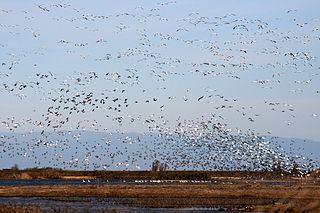
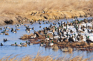
The Sacramento National Wildlife Refuge Complex is part of the United States system of National Wildlife Refuges (NWR). It is located in northern California, in the valley of the Sacramento River.

The Niobrara River is a tributary of the Missouri River, approximately 568 miles (914 km) long, running through the U.S. states of Wyoming and Nebraska. The river drains one of the most arid sections of the Great Plains, and has a low flow for a river of its length. The Niobrara's watershed includes the northern tier of Nebraska Sandhills, a small south-central section of South Dakota, as well as a small area of eastern Wyoming.

The Island Park Caldera, in the U.S. states of Idaho and Wyoming, is one of the world's largest calderas, with approximate dimensions of 80 by 65 km. Its ashfall is the source of the Huckleberry Ridge Tuff that is found from southern California to the Mississippi River near St. Louis. This super-eruption of approximately 2,500 km3 (600 cu mi) occurred 2.1 Ma and produced 2,500 times as much ash as the 1980 eruption of Mount St. Helens. Island Park Caldera has the smaller and younger Henry's Fork Caldera nested inside it.

Butte College is a public community college in the Butte-Glenn Community College District in Chico and Orland, California.
Lamesteer National Wildlife Refuge is an 800-acre (320 ha) National Wildlife Refuge in eastern Montana, U.S. All of the acreage is an easement refuge and is on privately owned land but the landowners and U.S. Government work cooperatively to protect the resources. The refuge was set aside to preserve habitat for migratory birds that frequent Lamesteer Reservoir, and the refuge and reservoir are named after Lame Steer Creek. The refuge is unstaffed and is managed from Medicine Lake National Wildlife Refuge.

Tempe Butte is the official name of an andesite butte of volcanic origin, located partially on Arizona State University's Tempe campus in Tempe, Arizona. It is often referred to by locals as A Mountain, after the 60-foot-tall (18 m) gold-painted letter 'A' near the top. Another name for the area, used by the City of Tempe, is Hayden Butte.
Lacreek National Wildlife Refuge is a National Wildlife Refuge of the United States located in South Dakota. It covers 16,410 acres (66.4 km2) and is managed by the United States Fish and Wildlife Service.

The Salmon–Huckleberry Wilderness is a wilderness area located on the southern side of Mount Hood in the northwestern Cascades of Oregon, in the United States. It lies within the Mount Hood National Forest and comprises 62,061 acres (25,115 ha) of land. The United States Congress designated the area Wilderness in 1984.

According to the California Protected Areas Database (CPAD), in the state of California, United States, there are over 14,000 inventoried protected areas administered by public agencies and non-profits. In addition, there are private conservation areas and other easements. They include almost one-third of California's scenic coastline, including coastal wetlands, estuaries, beaches, and dune systems. The California State Parks system alone has 270 units and covers 1.3 million acres (5,300 km2), with over 280 miles (450 km) of coastline, 625 miles (1,006 km) of lake and river frontage, nearly 18,000 campsites, and 3,000 miles (5,000 km) of hiking, biking, and equestrian trails.
The Denman Wildlife Area is a wildlife management area near Eagle Point, Oregon, in the United States. It was named in honor of Kenneth Denman, an attorney from nearby Medford, Oregon, who lobbied for the creation of the area in 1954.
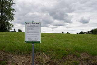
Clatsop Butte is an upland butte lying directly south of Powell Butte in southeast Portland, Oregon, United States. Clatsop Butte City Park, which occupies part of the butte, is at coordinates 45°28′28″N122°30′24″W at an elevation of 577 feet (176 m). Johnson Creek, Southeast Foster Road, and the Springwater Corridor Trail pass between Powell Butte and Clatsop Butte near Southeast 152nd Avenue.

The North Table Mountain Ecological Reserve is a nature reserve of 3,315 acres (13.42 km2) located three miles (5 km) north of Oroville, in Butte County, northern California. The land was acquired by the state in October, 1993.

The Butte Creek Ecological Preserve and Butte Creek Canyon Ecological Reserve consist of 2 distinct management units, the Preserve, aka the "Honey Run Unit" 93 acres (0.38 km2) owned and managed by the Chico State Research Foundation, and the "Virgin Valley" and "Canyon" Units 287 acres (1.16 km2), owned and managed by the California Department of Fish and Wildlife. The units are located east of Chico along Butte Creek in northern California. This stretch of Butte Creek is spawning habitat for the largest population of Central Valley spring-run Chinook salmon, an evolutionarily significant unit that is listed as threatened under the Endangered Species Act. Fall-run Chinook salmon and steelhead trout also spawn in the creek.

Little Butte Creek is a 17-mile-long (27 km) tributary of the Rogue River in the U.S. state of Oregon. Its drainage basin consists of approximately 354 square miles (917 km2) of Jackson County and another 19 square miles (49 km2) of Klamath County. Its two forks, the North Fork and the South Fork, both begin high in the Cascade Range near Mount McLoughlin and Brown Mountain. They both flow generally west until they meet near Lake Creek. The main stem continues west, flowing through the communities of Brownsboro, Eagle Point, and White City, before finally emptying into the Rogue River about 3 miles (5 km) southwest of Eagle Point.
Located within 11 counties in the Sacramento Valley and the Sacramento-San Joaquin Delta of California, North Central Valley Wildlife Management Area consists of conservation easements acquired on privately owned wetlands. The landscape is very flat, bordered by the Sierra and Coast ranges and is surrounded by intensive agriculture.

Butte Sink Wildlife Management Area is located in Colusa, Butte, and Sutter Counties. It is wetlands managed as part of the Sacramento National Wildlife Refuge Complex and is not open to the public.

Hi Vista is an unincorporated community in northeastern Los Angeles County, California, United States.
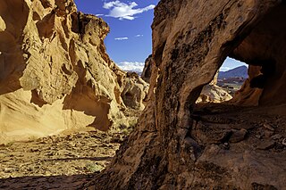
Gold Butte National Monument is a United States national monument located in Clark County, Nevada, northeast of Las Vegas and south of Mesquite and Bunkerville. The monument protects nearly 300,000 acres of desert landscapes featuring a wide array of natural and cultural resources, including rock art, sandstone towers, and important wildlife habitat for species including the Mojave Desert tortoise, bighorn sheep, and mountain lion. The area also protects historic ranching and mining sites such as the ghost town of Gold Butte, although little but mine openings, cement foundations, and a few pieces of rusting equipment remains. The monument is managed by the Bureau of Land Management.
