Related Research Articles
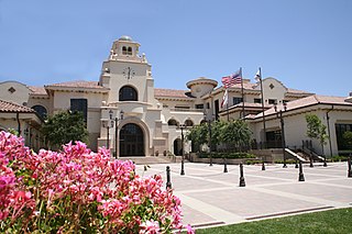
Temecula is a city in southwestern Riverside County, California, United States. The city is a tourist and resort destination, with the Temecula Valley Wine Country, Old Town Temecula, the Temecula Valley Balloon & Wine Festival, the Temecula Valley International Film Festival, championship golf courses, and resort accommodations for tourists which contribute to the city's economic profile. Although Temecula is geographically closer to downtown San Diego than downtown Los Angeles, it is considered part of the Greater Los Angeles area.

The Santa Margarita River which with the addition of what is now Temecula Creek, was formerly known as the Temecula River, is a short intermittent river on the Pacific coast of southern California in the United States, approximately 30.9 miles (49.7 km) long. One of the last free-flowing rivers in southern California, it drains an arid region at the southern end of the Santa Ana Mountains, in the Peninsular Ranges between Los Angeles and San Diego.
Temecula Valley Unified School District is the school district for schools in the city of Temecula, California and in unincorporated parts of nearby Murrieta and Winchester, California. It is the fourth largest school district in Riverside County. The district's Board of Education elections take place in November of even-numbered years and elected members serve a four-year term. The Board of Education is composed of five members, elected by geographical district, called Trustee Areas.

Vail Lake is a large reservoir in western Riverside County, southern California.
Temecula Creek, formerly known as the Temecula River, runs 32.6 miles (52.5 km) through southern Riverside County, California, United States, past the rural communities of Radec and Aguanga, and ending 0.5 miles (0.80 km) southeast of the original city center of Temecula. The creek is filled with boulders and is typically dry and sandy. It is a relatively undeveloped coastal-draining watershed. Until the 1920s, water flowed in Temecula Creek year-round.
Warner Springs is set of springs and a small unincorporated community in northern San Diego County, California.
The Soboba Band of Luiseño Indians is a federally recognized tribe of Luiseño people, headquartered in Riverside County, California. On June 18, 1883, the Soboba Reservation was established by the United States government in San Jacinto. There are five other federally recognized tribes of Luiseño people in southern California.
Rancho Little Temecula was a 2,233-acre (9.04 km2) Mexican land grant in present-day Riverside County, California given in 1845 by Governor Pío Pico to Pablo Apis. The grant was one of the few held by indigenous people. The grant is south of present-day Temecula and is bordered on the north by Temecula Creek. At the time of the US patent, Rancho Little Temecula was a part of San Diego County. Riverside County was created by the California Legislature in 1893 by taking land from both San Bernardino and San Diego Counties.
Rancho Temecula was a 26,609-acre (107.68 km2) Mexican land grant in present-day Riverside County, California given on December 14, 1844 by Governor Manuel Micheltorena to Feliz Valdez. The grant extended south along the east bank Murrieta Creek to Temecula Creek and encompassed present-day Temecula, Murrieta and Murrieta Hot Springs. At the time of the US patent, Rancho Temecula was a part of San Diego County. Riverside County was created by the California Legislature in 1893 by taking land from both San Bernardino and San Diego Counties.
Rancho Pauba was a 26,598-acre (107.64 km2) Mexican land grant in present-day Riverside County, California given in 1844 by Governor Manuel Micheltorena to Vicente Moraga and Luis Arenas. The grant was just east of present-day Temecula. At the time of the US patent, Rancho Pauba was a part of San Diego County. Riverside County was created by the California Legislature in 1893 by taking land from both San Bernardino and San Diego Counties.
The Butterfield Overland Mail in California was created by the United States Congress on March 3, 1857, and operated until June 30, 1861. Subsequently, other stage lines operated along the route until the Southern Pacific Railroad arrived in Yuma, Arizona in 1877.
Earthquake Valley is a desert valley east of Julian, California, which contains parts of the Anza-Borrego Desert State Park. It is the location of the Shelter Valley Ranchos subdivision, which is also known as the unincorporated community of Shelter Valley. The official USGS place name for the geologic feature in which Shelter Valley is situated is "Earthquake Valley", and the 1959 USGS Topographic map makes no reference to Shelter Valley. The name of the unincorporated community Shelter Valley is typically used both locally and by the media to refer generally to the geological feature of Earthquake Valley, and it is common for both names to be referenced in publications after the 1962 establishment of the subdivision. Author, poet, artist and primitivist Marshal South lived in and wrote about the general area, in a series of articles for Desert Magazine between 1941 and 1948. A number of notable trails pass through the valley, including the Pacific Crest Trail, the California Riding and Hiking Trail, and the Southern Emigrant Trail.

San Felipe Valley is an inland valley of the Peninsular Ranges, located in eastern San Diego County, California. Most of the valley is protected within the San Felipe Valley Wildlife Area.
The Perris Block is the central block of three major fault-bounded blocks of the northern part of the Peninsular Ranges. The Perris Block lies between the Santa Ana Block to the west and the San Jacinto Block to the east. The Perris Block, was named by Walter A. English in 1925 for the city of Perris, located near the center of the block.
Oriflamme Canyon is a steep mountain canyon, in San Diego County, California that descends from its head in the Laguna Mountains, at 32°56′41″N116°29′45″W, in an arc northwestward then northeastward to join Rodriguez Canyon at the northwest end of Mason Valley, where Vallecito Wash has its source.
Radec is a small unincorporated community in Riverside County, California, United States. Located roughly 15 miles east by southeast of the city of Temecula, the community of Radec is located along Highway 79. Having bought land in the area in 1883, early settler Samuel Tripp set up a post office there. As of 1893–4, a local directory listed the area as growing honey, hay and stock, but also as having "no commercial interest of any kind." A total of 14 people, mainly farmers and beekeepers, plus a laborer and Tripp, are listed in the directory. The County of Riverside owns a small, non-operational cemetery in Radec.
Oak Mountain is a mountain in the northern Peninsular Ranges System, in Riverside County, in southern California.
Hamilton Creek is a tributary stream of Cahuilla Creek,, in Riverside County, California. Its mouth is found in the Anza Valley at an elevation of 3,865 feet (1,178 m). Its source is at 33°32′46″N116°34′36″W at an elevation of 4,800 feet on the southwest facing slope of Lookout Mountain in the Santa Rosa Mountains.
Cahuilla Creek is a tributary stream of Wilson Creek which is in turn a tributary of Temecula Creek, and the Santa Margarita River in Riverside County, California. Its mouth is at its confluence with Wilson Creek at an elevation of 2,106 feet (642 m). Its source is at 33°36′40″N116°40′10″W, at an elevation of 5,800 feet, on the west slope of Thomas Mountain 0.6 miles west-southwest of Tool Box Spring. It flows southwest through the Anza Valley and Cahuilla Valley in the Cahuilla Indian Reservation to Wilson Creek, 7 miles south-southwest of Cahuilla Mountain and 20 miles south-southeast of San Jacinto.
Anza Valley, formerly known as the Hamilton Plains, is a basin in Riverside County, California. Anza Valley trends southwest from Bautista Canyon, west of Thomas Mountain to Terwilliger Valley, 2.8 miles west-southwest of Table Mountain and 12 miles south of Idyllwild. The valley lies at an elevation of 4,157 feet (1,267 m), west of the San Jacinto and Santa Rosa Mountains. It is drained by Cahuilla Creek, a tributary of the Santa Margarita River.
References
- ↑ U.S. Geological Survey Geographic Names Information System: Pauba Valley
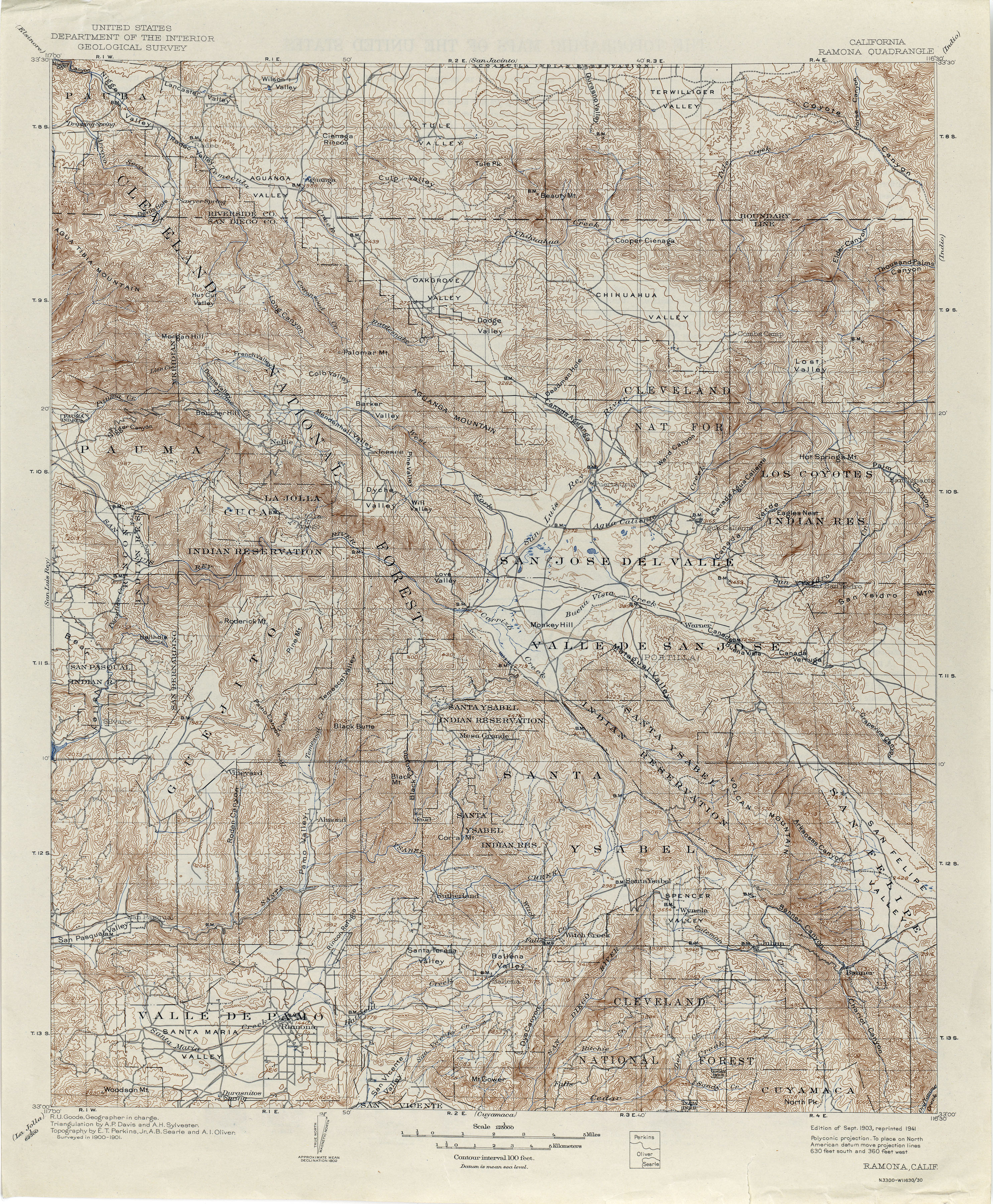
- ↑ California, Ramona Quadrangle, 1903 reprinted 1941
- ↑ Robert L. Carlton, Blacks in San Diego County: A Social Profile, 1850-1880, The Journal of San Diego History, SAN DIEGO HISTORICAL SOCIETY QUARTERLY, Volume 21, Number 4, Fall 1975 [ permanent dead link ]
- ↑ U.S. Geological Survey Geographic Names Information System: Anza Valley
- ↑ Steve Lech, Pioneers of Riverside County: The Spanish, Mexican, and Early American Periods, Arcadia Publishing, Dec 10, 2012, Notes, Chapter 4, note 58.
- ↑ U.S. Geological Survey Geographic Names Information System: Hamilton Creek
- ↑ U.S. Geological Survey Geographic Names Information System: Hamilton School
- ↑ About Us > School History from hamiltonbobcats.net accessed August 23, 2016.
- ↑ Edgar F. Hastings, “An Interview with HARRY P. JONES” (March 10, 1960), Seth Mallios, Sarah Stroud, Lauren Lingley, Jaime Lennox, Hillary Sweeney, Olivia Smith, and David Caterino, Archaeological Excavations at the Nate Harrison Site in San Diego County, California: An Interim Technical Report for the 2005 Field Season, © 2006 by San Diego State University, Department of Anthropology
Coordinates: 33°29′45″N116°58′36″W / 33.49583°N 116.97667°W