Highland Falls, formerly named Buttermilk Falls, is a village in Orange County, New York, United States. The population was 3,900 at the 2010 census. The village was founded in 1906. It is part of the Poughkeepsie–Newburgh–Middletown, NY Metropolitan Statistical Area as well as the larger New York–Newark–Bridgeport, NY-NJ-CT-PA Combined Statistical Area.

Buttermilk is a dairy drink. Originally, buttermilk was the liquid left behind after churning butter out of cultured cream. This type of buttermilk is now specifically referred to as traditional buttermilk.

Buttermilk Channel is a small tidal strait in Upper New York Bay in New York City, approximately 1 mile (1.6 km) long and 0.25 miles (0.40 km) wide, separating Governors Island from Brooklyn. The channel is marked by a number of navigation aids. Tidal currents on the channel are rather strong.

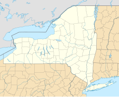
Buttermilk Falls State Park is a 811-acre (3.28 km2) state park located southwest of Ithaca, New York, United States. Like Robert H. Treman State Park, a portion of the land that was to become the state park came from Robert and Laura Treman in 1924.

The Onondaga Limestone is a group of hard limestones and dolostones of Devonian age that form an important geographic feature in some areas in which it outcrops, in others; especially its Southern Ontario portion, the formation can be less prominent as a local surface feature.

Stony Brook State Park is a 568-acre (2.30 km2) state park located in Steuben County, New York. It is located south of Dansville on New York State Route 36.

The Raquette River, sometimes spelled Racquette, originates at Raquette Lake in the Adirondack Mountains in New York. 146 miles (235 km) long, it is the third longest river entirely in the state of New York.

Robert H. Treman State Park is a 1,110-acre (4.5 km2) state park located in Tompkins County, in the Finger Lakes region of New York in the United States. The park is situated in the towns of Ithaca, Enfield and Newfield.
Central Nyack is a hamlet in the Town of Clarkstown Rockland County, New York, United States approximately 20 miles north of New York City located north of Blauvelt; east of West Nyack; south of Valley Cottage, and west of the Village of Nyack. As an unincorporated community, governmental functions default to the town level (Clarkstown). The community is located at latitude 41.094 and longitude -73.95. The elevation is 62 feet. The neighborhood is in a mountain-view area, situated just north of Buttermilk Falls County Park and Stephen Rowe Bradley Town Park.
This is a list of trails in Ithaca, New York.
Cochrane Road is a two-way Lower City collector road in Hamilton, Ontario, Canada. It starts off at the Queenston Traffic Circle and travels South between the Bartonville and Glenview neighbourhoods right through to the Rosedale neighbourhood where it ends at Greenhill Avenue in front of Rosedale Park. From this point onwards the road is now known as Whitehouse Road and weaves its way through King's Forest Golf Course and King's Forest Park.
Limeridge Road is a two-way Upper City (mountain) collector road in Hamilton, Ontario, Canada. It starts off just West of Garth Street/William McCulloch Park as Limeridge Court and cuts across the Hamilton mountain eastward running parallel with the Lincoln M. Alexander Parkway and ends at Mountain Brow Boulevard, South of Mohawk Sports Park in front of Upper King's Forest Park.

Peekamoose Mountain is a mountain located in Ulster County, New York. The mountain is part of the Catskill Mountains. Peekamoose Mountain is flanked to the north by Table Mountain. The name Peekamoose is possibly a corruption of an Algonquin word meaning 'broken off smooth', cf. Poke-O-Moonshine Mountain.

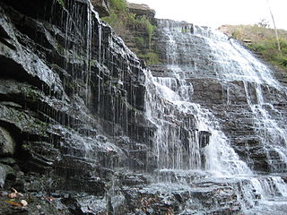
Buttermilk Falls is a 23 metre high plunge waterfall found below Oak Knoll Park in Hamilton, Ontario, Canada.
Buttermilk Falls is a waterfall in Hamilton, Ontario, Canada.
Buttermilk Creek may refer to:
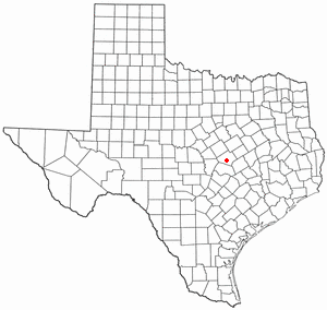
Buttermilk Creek Complex refers to the remains of a paleolithic settlement along the shores of Buttermilk Creek in present-day Salado, Texas dated to approximately 15,500 years old. If confirmed, the site represents evidence of human settlement in the Americas that pre-dates the Clovis culture.

Buttermilk Creek is a tributary of the Susquehanna River in Lackawanna County and Wyoming County, in Pennsylvania, in the United States. It is approximately 6.8 miles (10.9 km) long and flows through Newton Township in Lackawanna County and Falls Township in Wyoming County. The watershed of the creek has an area of 26.1 square miles (68 km2). The creek is a perennial stream and is not designated as an impaired waterbody. Major geographical features in its watershed include the Buttermilk Falls in its lower reaches, as well as Fords Lake and Lake Winola.

Buttermilk Falls is located on Oak Creek northeast of Worcester, New York and just south of Gothicville, New York.
Buttermilk Falls also known as Adriucha or Adriutha is a waterfall located on Yatesville Creek northeast of Currytown, New York.