
Rochdale is a large town in Greater Manchester, England, at the foothills of the South Pennines in the dale on the River Roch, 5.3 miles (8.5 km) northwest of Oldham and 9.8 miles (15.8 km) northeast of Manchester. It is the administrative centre of the Metropolitan Borough of Rochdale, which had a population of 211,699 in 2011.

The Huddersfield Narrow Canal is an inland waterway in northern England. It runs just under 20 miles (32 km) from Lock 1E at the rear of the University of Huddersfield campus, near Aspley Basin in Huddersfield, to the junction with the Ashton Canal at Whitelands Basin in Ashton-under-Lyne. It crosses the Pennines by means of 74 locks and the Standedge Tunnel.

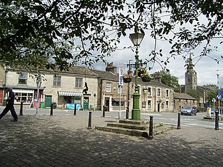
Milnrow is a suburban town within the Metropolitan Borough of Rochdale, in Greater Manchester, England. It lies on the River Beal at the foothills of the South Pennines, and forms a continuous urban area with Rochdale. It is 1.9 miles (3.1 km) east of Rochdale town centre, 10.4 miles (16.7 km) north-northeast of Manchester, and spans urban, suburban and rural locations—from Windy Hill in the east to the Rochdale Canal in the west. Milnrow is adjacent to junction 21 of the M62 motorway, and includes the village of Newhey, and hamlets at Tunshill and Ogden.

The River Roch is a river in Greater Manchester in North West England, a tributary of the River Irwell, that gives Rochdale its name.
Littleborough is a town within the Metropolitan Borough of Rochdale, in Greater Manchester, England. It is located in the upper Roch Valley by the foothills of the South Pennines, 3 miles (4.8 km) northeast of Rochdale and 12.6 miles (20.3 km) north-northeast of Manchester; Milnrow and the M62 motorway are to the south, and the rural uplands of Blackstone Edge are to the east. In 2001, Littleborough and its suburbs of Calderbrook, Shore and Smithy Bridge, had a population of 13,807.

Oldham East and Saddleworth is a constituency in outer Greater Manchester represented in the House of Commons of the UK Parliament since January 2011 by Debbie Abrahams of the Labour Party.

The River Spodden is a watercourse in North West England, one of two major tributaries of the River Roch. It rises in the Lancashire South Pennine hills north of Whitworth and flows south through what is now known as the Whitworth Valley to Rochdale, Greater Manchester, where the river merges with the River Roch. Nestled within the picturesque wooded valley is Healey Dell Nature Reserve.

Newhey is a suburban village in the Milnrow area of the Metropolitan Borough of Rochdale, in Greater Manchester, England. It lies at the foot of the South Pennines, by Junction 21 of the M62 motorway and on the River Beal, 2.7 miles (4.3 km) east-southeast of Rochdale, 10.3 miles (16.6 km) northeast of Manchester.

The Blackburn Brook is a stream in Sheffield, South Yorkshire, England which flows through the Blackburn Valley along the M1 and Ecclesfield Road and joins the River Don near the Meadowhall shopping centre. Downstream from the A61 road at Chapeltown the Blackburn Brook is defined as a main river by the Environment Agency, which requires new building development to be at least 26 feet (8 m) from the bank side as a flood defence measure and to allow access to the watercourse for maintenance.

The Beal is a small river in Greater Manchester, England, and is a tributary of the River Roch. It rises in the Beal Valley in green space between Sholver and Royton, before continuing northwards through Shaw and Crompton, Newhey, Milnrow and Belfield.

John Collier was an English caricaturist and satirical poet known by the pseudonym of Tim Bobbin, or Timothy Bobbin. Collier styled himself as the Lancashire Hogarth.

Butterworth was a township occupying the southeastern part of the parish of Rochdale, in the hundred of Salford, Lancashire, England. It encompassed 12.1 square miles (31 km2) of land in the South Pennines which spanned the settlements of Belfield, Bleaked-gate-cum-Roughbank, Butterworth Hall, Clegg, Haughs, Hollingworth, Kitcliffe, Lowhouse, Milnrow, Newhey, Ogden, Rakewood, Smithy Bridge, Tunshill and Wildhouse. It extended to the borders of Crompton to the south, and to the highest points of Bleakedgate Moor and Clegg Moor, up to the ridge of Blackstone Edge, to the east, where its boundary was the old county boundary between Lancashire and Yorkshire.

Ogden Reservoir is a reservoir in the Piethorne Valley, close to Milnrow and Newhey in the Metropolitan Borough of Rochdale, within Greater Manchester, England.

Piethorne Brook is a watercourse in Greater Manchester. It is a tributary of the River Beal.

Piethorne Reservoir is the largest of several reservoirs in the Piethorne Valley above Newhey, by Milnrow, in the Metropolitan Borough of Rochdale, Greater Manchester, England. It was built between 1858 and 1868.

Stanney Brook is a watercourse in Greater Manchester, England. It originates in the Burnedge area of Shaw and Crompton, and flows through Milnrow into Rochdale before joining the River Roch at Newbold Brow. Alone among the watercourses of Milnrow and Newhey, it does not pass through the centre of either village, and flows directly into the River Roch, rather than first into the River Beal. Its name derives from the Lancashire dialect word "stanner", a ridge of stones. It is also unusual in that the borough in which it rises, changes, depending on the wetness of surrounding moorland. The brook drops 100 metres in a little over 5.5 kilometres, or 330feet in 3.5 miles. It is culverted four times, generally is only 60 cm (2 ft) wide, and rarely exceeds 90 cm (3 ft) in width at any point.

Belfield is a rough area within Rochdale, in Greater Manchester, England. It lies at the confluence of the River Beal and River Roch, 1.3 miles (2.1 km) east-northeast of Rochdale's town centre. Belfield is bound to the east by the Rochdale Canal, which forms Rochdale's common boundary with Firgrove in Milnrow.

Ellenroad Mill was a cotton spinning mill in Newhey, Milnrow, Rochdale, Greater Manchester, England. It was built as a mule spinning mill in 1890 by Stott and Sons and extended in 1899. It was destroyed by fire on 19 January 1916. When it was rebuilt, it was designed and equipped as a ring spinning mill.


