Bzebdine بزبدين | |
|---|---|
 | |
| Coordinates: 33°52′18″N35°43′52″E / 33.8716°N 35.7310°E | |
| Country | |
| Governorate | Mount Lebanon |
| District | Baabda District |
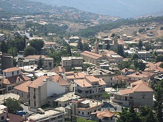
Bzebdine (Arabic : بزبدين) is a municipality in Baabda District, Mount Lebanon Governorate, Lebanon. [1]
Bzebdine بزبدين | |
|---|---|
| | |
| Coordinates: 33°52′18″N35°43′52″E / 33.8716°N 35.7310°E | |
| Country | |
| Governorate | Mount Lebanon |
| District | Baabda District |
Bzebdine (Arabic : بزبدين) is a municipality in Baabda District, Mount Lebanon Governorate, Lebanon. [1]
The nine governorates of Lebanon are subdivided into 25 districts. Beirut Governorate is not subdivided into districts, and Akkar Governorate comprises a single district.

Mount Lebanon Governorate is one of the nine governorates of Lebanon. Its capital is Baabda. Other notable towns and cities include Aley, Bikfaya, and Beit Mery.

Baabda is the capital city of Baabda District and Mount Lebanon Governorate, in western Lebanon. Baabda was also the capital city of the autonomous Ottoman Mount Lebanon that existed from 1861 to 1918.

Baabda District, sometimes spelled B'abda, is a district (qadaa) of Mount Lebanon Governorate, Lebanon, to the south and east of the Lebanon's capital Beirut. The region is also popularly known as "Southern Matn District", as distinct from Northern Matn District,. The capital of Baabda District is the city of Baabda.

Haret Hreik is a mixed Shia and Maronite Christian municipality, in the Dahieh suburbs, south of Beirut, Lebanon. It is part of the Baabda District. Once an agricultural village, Haret Hreik lost its rural identity due to the wave of refugees from Southern Lebanon who settled in the town and made it another urban neighborhood of Dahieh.
Chiyah is situated in the west region of the Lebanese capital of Beirut and is part of Greater Beirut.
Hammana is a town in Lebanon, about 26 km east of Beirut. At an altitude of 1200 m above sea level, Hammana is in the Mount Lebanon Governorate in the district of Baabda. Hammana is bordered by the towns of Falougha, Shbaniye, Khraybe, Bmariam, Khalwet and Mdeirej.
Souk El Gharb, also spelled Suk, Sug al, ul, Suq), is a town located in the Aley District, Mount Lebanon Governorate, in Lebanon and its name translates to "Western Market".
Daychounieh is a village in the Matn District of the Mount Lebanon Governorate, Lebanon. Daychounieh is administered by Mansourieh municipality.
Falougha - Khalwat Falougha is a municipality in the Baabda District of Mount Lebanon Governorate, Lebanon. The municipality consists of the villages of Falougha and Khalwat Falougha. It is 35 kilometers east of Beirut. Falougha - Khalwat Falougha has an average elevation of 1,250 meters above sea level and a total land area of 1,563 hectares. In 2016, Falougha had 3,400 registered voters while Khalwat Falougha had 600. There is a public school in the village with 150 students as of 2016 and a local hospital with thirty beds. There are seven companies that each employ over five employees operating in Falougha. Falougha has a mixed population of Druze and Christians from the Maronite, Melkite and Greek Orthodox denominations, while Khalouat Falougha's inhabitants are entirely Druze.
Bsalim is a town in the Matn District in Mount Lebanon Governorate in Lebanon. The population is almost exclusively Christian.
Bsaba, also written as Bessaba, Bisaba, Bisābā, Bseba El Chouf, is a village in Chouf District, Lebanon. Bsaba is a member of Federation of South Iqlim El Kharroub Municipalities.
Salima is a municipality in the Baabda District of Mount Lebanon Governorate, Lebanon. There is one public school in the village with 130 students as of 2006.
Btekhnay is a municipality in the Baabda District of Mount Lebanon Governorate, Lebanon. It is located 42 kilometers east of Beirut. There is one public school in the village with 400 students as of 2016. Ten companies with over fifteen employees operate in the village.
Daraya, also known as Dheira, is a Lebanese village located in Chouf District in Mount Lebanon Governorate. The name is derived from "Dar" which means house or home.
Kfar Silwan is a municipality in the Baabda District of Mount Lebanon Governorate, Lebanon. It is 49 kilometres (30 mi) north of Beirut. Kfar Silwan has an average elevation of 1,380 metres (4,530 ft) above sea level and a total land area of 1,471 hectares. It had 2,736 registered voters in 2010. Its inhabitants are predominantly Maronites and Druze.

Chbaniyeh is a municipality in the Baabda District of Mount Lebanon Governorate, Lebanon. It is 29 kilometres (18 mi) north of Beirut. Chbaniyeh has an average elevation of 860 metres (2,820 ft) above sea level and a total land area of 485 hectares. It has a religiously-mixed population Maronites, Melkites and Druze.

Ain El Remmaneh is a Christian neighborhood, in the Baabda district of Mount Lebanon, Lebanon, a suburb of Beirut and part of Greater Beirut.
Jouar el Haouz is a municipality in the Baabda District of the Mount Lebanon Governorate of Lebanon. It is located 36 kilometers east of Beirut. Its average elevation is 1,250 m (4,100 ft) above sea level, and its total land area is 377 hectares. The municipality is member of Federation of Matn El Aala Municipalities.
Bmaryam, also spelled Bmariam, is a village in Baabda District, Mount Lebanon Governorate, Lebanon.
Capital: Baabda | ||
| Towns and villages | 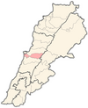 | |
| | This Lebanon location article is a stub. You can help Wikipedia by expanding it. |