Related Research Articles

Stonehenge is a prehistoric megalithic structure on Salisbury Plain in Wiltshire, England, two miles (3 km) west of Amesbury. It consists of an outer ring of vertical sarsen standing stones, each around 13 feet (4.0 m) high, seven feet (2.1 m) wide, and weighing around 25 tons, topped by connecting horizontal lintel stones. Inside is a ring of smaller bluestones. Inside these are free-standing trilithons, two bulkier vertical sarsens joined by one lintel. The whole monument, now ruinous, is aligned towards the sunrise on the summer solstice and sunset on the winter solstice. The stones are set within earthworks in the middle of the densest complex of Neolithic and Bronze Age monuments in England, including several hundred tumuli.

A megalith is a large stone that has been used to construct a prehistoric structure or monument, either alone or together with other stones. There are over 35,000 in Europe alone, located widely from Sweden to the Mediterranean sea.

A causewayed enclosure is a type of large prehistoric earthwork common to the early Neolithic in Europe. It is an enclosure marked out by ditches and banks, with a number of causeways crossing the ditches. More than 100 examples are recorded in France and 70 in Southern England and Wales, while further sites are known in Scandinavia, Belgium, Germany, Italy, Ireland and Slovakia.
Carrowmore is a large group of megalithic monuments on the Coolera Peninsula to the west of Sligo, Ireland. They were built in the 4th millennium BC, during the Neolithic. There are thirty surviving tombs, making Carrowmore one of the largest clusters of megalithic tombs in Ireland, and one of the 'big four' along with Carrowkeel, Loughcrew and Brú na Bóinne. Carrowmore is the heart of an ancient ritual landscape which is dominated by the mountain of Knocknarea to the west. It is a protected National Monument.
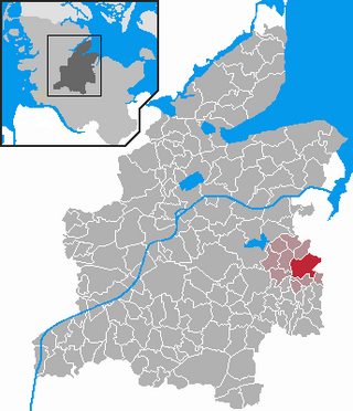
Flintbek is a municipality in the district of Rendsburg-Eckernförde, in Schleswig-Holstein, Germany. It is on the River Eider, c. 10 km southwest of Kiel. The meaning of the name is controversial but one possibility is the combination of flint(stone) with the word bek.

Brú na Bóinne, also called the Boyne Valley tombs, is an ancient monument complex and ritual landscape in County Meath, Ireland, located in a bend of the River Boyne. It is one of the world's most important Neolithic landscapes, comprising at least ninety monuments including passage tombs, burial mounds, standing stones and enclosures. The site is dominated by the passage tombs of Newgrange, Knowth and Dowth, built during the 32nd century BC. Together these have the largest assemblage of megalithic art in Europe. The associated archaeological culture is called the "Boyne culture".
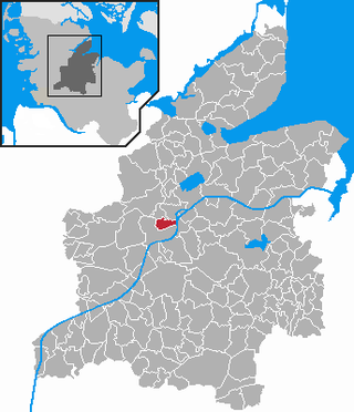
Büdelsdorf is a town in the district of Rendsburg-Eckernförde, in Schleswig-Holstein, Germany. It is situated on the river Eider and the Kiel Canal, approx. 2 kilometres north of Rendsburg, and 30 km (19 mi) west of Kiel, just 5 mi (8 km) off the motorway.

Schülp bei Rendsburg is a municipality in the district of Rendsburg-Eckernförde, in Schleswig-Holstein, Germany.
The Wartberg culture, sometimes: Wartberg group (Wartberggruppe) or Collared bottle culture (Kragenflaschenkultur) is a prehistoric culture from 3,600 -2,800 BC of the later Central European Neolithic. It is named after its type site, the Wartberg, a hill near Niedenstein-Kirchberg in northern Hesse, Germany.
C. Joshua Pollard is a British archaeologist who is a professor of archaeology at the University of Southampton. He gained his BA and PhD in archaeology from the Cardiff University, and is a specialist in the archaeology of the Neolithic period in the UK and north-west Europe, especially in relation to the study of depositional practices, monumentality, and landscape. He is a Fellow of the Society of Antiquaries of London

Nordic megalith architecture is an ancient architectural style found in Northern Europe, especially Scandinavia and North Germany, that involves large slabs of stone arranged to form a structure. It emerged in northern Europe, predominantly between 3500 and 2800 BC. It was primarily a product of the Funnelbeaker culture. Between 1964 and 1974, Ewald Schuldt in Mecklenburg-Western Pomerania excavated over 100 sites of different types: simple dolmens, extended dolmens, passage graves, great dolmens, unchambered long barrows, and stone cists. In addition, there are polygonal dolmens and types that emerged later, for example, the Grabkiste and Röse. This nomenclature, which specifically derives from the German, is not used in Scandinavia where these sites are categorised by other, more general, terms, as dolmens, passage graves and stone cists.

The simple dolmen or primeval dolmen is an early form of dolmen or megalithic tomb that occurs especially in Northern Europe. The term was defined by archaeologist, Ernst Sprockhoff, and utilised by Ewald Schuldt in publicising his excavation of 106 megalithic sites in the north German state of Mecklenburg-Vorpommern. The simple dolmen emerged in the early days of the development of megalithic monuments of the Funnelbeaker culture (TBK) and around 3,500 BC they appeared across almost the entire region covered by the stone cult structures of Nordic megalith architecture, but not in the Netherlands, in Lower Saxony west of the River Weser nor east of the River Oder and only once in Sweden.

A rectangular dolmen, extended dolmen or enlarged dolmen is a specific type of megalith, rectangular in shape, with upright sidestones and, usually, two capstones. The term rectangular dolmen was coined by Ekkehard Aner and is used especially in the German state of Schleswig-Holstein, where dolmens with this type of ground plan primarily occur. A more precise term, however, is extended dolmen, used by Ewald Schuldt and Ernst Sprockhoff, because these types of dolmen also occur with trapezoidal ground plans.
A polygonal dolmen is a megalithic architectural structure and often depicted as the archetypal dolmen.

The unchambered long barrowearthen long barrow, non-megalithic long barrow or non-megalithic mound, is a type of long barrow found across the British Isles, in a belt of land in Brittany, and in northern Europe as far east as the River Vistula. The term "unchambered" means that there is no stone chamber within the stone enclosure. In Great Britain they are often known as non-megalithic long barrows or unchambered long cairns.

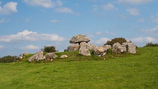
The Harhoog is a dolmen, a rectangular megalithic tomb from the Funnelbeaker culture, located near Keitum on the island of Sylt in Schleswig-Holstein, Germany. Discovered in 1925, it was moved to the present site in 1954 when a new airport was developed.

The Hütten Hills are an area of upland, up to 105.8 m above sea level (NHN), roughly west of the town of Eckernförde in the county of Rendsburg-Eckernförde in the North German state of Schleswig-Holstein. They lie within the Hütten Hills Nature Park.

The Eider Canal was an artificial waterway in southern Denmark which connected the North Sea with the Baltic Sea by way of the rivers Eider and Levensau. Constructed between 1777 and 1784, the Eider Canal was built to create a path for ships entering and exiting the Baltic that was shorter and less storm-prone than navigating around the Jutland peninsula. In the 1880s the canal was replaced by the enlarged Kiel Canal, which includes some of the Eider Canal's watercourse.
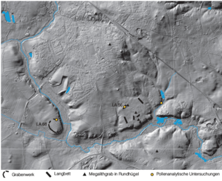
The site Albersdorf-Dieksknöll LA 68 is a causewayed enclosure of the fourth millennium BC in Albersdorf, district Dithmarschen, northern Germany. It is one of the three or four known enclosure sites in Schleswig-Holstein and of the 47 known causewayed enclosure of the Funnel Beaker Culture.
Magheraboy causewayed enclosure is an early Neolithic enclosure located near Sligo town in northwest Ireland.
References
- 1 2 3 4 5 Hage, Franziska (2015). Büdelsdorf/Borgstedt. Eine trichterbecherzeitliche Kleinregio (in German). Bonn: Verlag Dr. Rudolf Habelt GmbH. ISBN 978-3-7749-4043-7.
- ↑ Schwerpunktprogramm 1400, D. F. G. (2010-11-02). "Monumental enclosures, non-megalithic and megalithic tombs of the early and middle Neolithic in Schleswig-Holstein: Studies on the construction history, age determination, function and landscape relations within the micro regions Büdelsdorf and Albersdorf". www.monument.ufg.uni-kiel.de. Retrieved 2022-01-18.
{{cite web}}: CS1 maint: numeric names: authors list (link) - ↑ Müller 2019: J. Müller, Boom and bust, hierarchy and balance: From landscape to social meaning – Megaliths and societies in Northern Central Europe. In: J. Müller/M. Hinz/M. Wunderlich (Hrsg.), Megaliths – Societies – Landscapes. Early monumentality and social differentiation in Neolithic Europe. Verlag Rudolf Habelt GmbH (Bonn 2019) 29–74.
- ↑ "Why were themegalitictombs built?". National Museum of Denmark. Retrieved 2022-01-18.
- ↑ Müller 2018: J. Müller, Social memories and site biographies: construction and perception in non-literate societies. In: C.C. Bakels/ Q.P.J. Bourgeois/ D.R. Fontijn/R. Jansen (Hrsg.), Local communities in the Big Words of prehistoric Northwest Europe. Sidestone Press, (Leiden 2018) 9–17.
The main publication of the settlement and enclosure Büdelsdorf is available for free. Interested people can download many publications (monographs and collections, also in English language) from DFG the Priority Program 1400 "Early Monumentality and Social Differentiation" here.